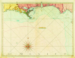
The Coast Of West Florida and Louisiana
This reproduction is of an engraving with watercolor map created on May 12, 1794, by Thomas Jefferys for the British Navy during the American Revolution.

Courtesy of The Historic New Orleans Collection
The Coast Of West Florida and Louisiana. Jefferys, Thomas (Cartographer)
Additional Data
| Courtesy of | The Historic New Orleans Collection |
| Date | 1794 |
| Copyright | Copyrighted |
| Disclaimer |
Physical rights are retained by the Historic New Orleans Collection. The Louisiana Endowment has included this work in 64parishes.org for the purposes of criticism, comment, teaching, scholarship, educational research, all other nonprofit educational usages under Section 107 of the U.S. Copyright Act. |