Magazine
Against the Flow
The lessons of the West Bay Sediment Diversion.
Published: March 1, 2018
Last Updated: April 21, 2021
William Widmer
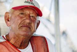
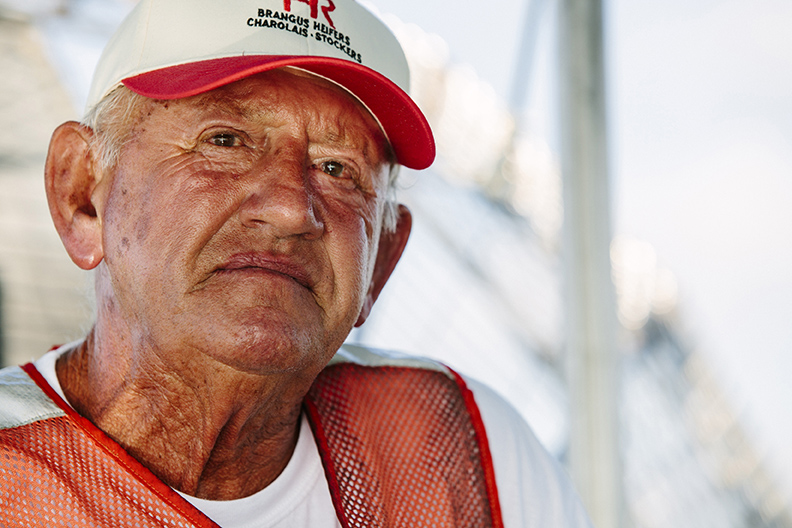
Earl Armstrong aboard his airboat in the shallow waters near the mouth of the Mississippi River in lower Plaquemines Parish.
Earl O. Armstrong’s airboat chugged out of Venice, Louisiana, and skated over winding bayous until finally, the boat went quiet near West Bay. Armstrong leaned over and said, “Look at those bubbles coming up! Yeah, plenty of times when we got new land, you see that.”The new land Armstrong pointed to is in West Bay, a large basin in Plaquemines Parish that flows into the Gulf of Mexico. Plaquemines extends off the very southernmost tip of Louisiana like an arm, its fingers grasping the Gulf of Mexico. But those fingers are slowly diminishing. Louisiana’s coast lost more than 1,800 square miles since 1932, and more of the coastline diminishes each year. Plaquemines, along with other southernmost points of Louisiana, are the first line of defense against rising seas and subsiding land. And Armstrong has had a front row seat watching his home turn into water.
But in this particular place, land is growing because of the West Bay Sediment Diversion, a project authorized in 1991 by the Coastal Wetlands Planning, Protection, and Restoration Act, otherwise known as the Breaux Act. The CWPPRA Task Force designed and built the diversion in 2003 with the goal to rebuild the Louisiana coast.
The West Bay Diversion was the first uncontrolled sediment diversion for restoration purposes built in Louisiana. Sediment diversions are one of the strategies used to rebuild land in the Louisiana Master Plan—the largest strategic land-building effort in the history of the United States. West Bay was an unprecedented project that allowed coastal restoration scientists to examine whether river diversions can successfully build land. But in many ways, without Armstrong, West Bay Diversion would not be creating new land today.
Paul Kemp, an oceanographer and head of the Audubon Institute’s Gulf Coast Initiative, an adjunct professor at Louisiana State University, and a commissioner on the Southeast Louisiana Flood Protection Authority, said, “[CWPPRA] would have closed that diversion off. It would have gone down in history as a failed project if Earl hadn’t got involved.”
That morning at the Venice boat launch, Armstrong wore a wide-brimmed white cowboy hat that shaded his crinkled, wide smile from the bright sun. He walked with a hitch in his gait but still moved quickly. Armstrong is seventy-three years old and has made his living off of the land, though he concedes it’s changed a lot over the course of his life. He is a cattle rancher in a place where the water keeps rising, leaving less and less room for his cattle to graze.
Armstrong quickly navigated through the bay toward the mouth of the Mississippi River, where his cattle wander from island to island, their boundaries limited only by deep waters. About one thousand of his cattle are spread over fourteen islets along Southwest Pass.
The remains of Pilottown, an old fishing village at the mouth of the Mississippi River in lower Plaquemines Parish, 2015. Photo by William Widmer
When Armstrong was a child, massive logs would float down the river, jamming up the waterway. Armstrong learned this was one of the ways the river built land. “It’s nothing you got to be a rocket scientist about,” he said. “Some of those logs would be eighty or ninety feet long and would run aground on the riverbank. When you get a high river, the water would run over the edges of the logs and start to build up a big sand bar behind it. My uncle taught me that if the log wasn’t there, the water wouldn’t go and make the silt flow out over the bank.”
When CWPPRA began building the West Bay Sediment Diversion, Armstrong understood exactly what they were doing—building land by letting sediment and water flow out of the river.The Mississippi River, a thick, coursing vein that gushes out into the sea, has been delivering life-giving sediment to this delta for more than seven thousand years. Beginning near the northern border of the United States, the river meanders through the heartland, passing farms and cities, glittering its way to the Gulf of Mexico. Running 2,320 miles from its headwaters to its mouth, and draining 41% of the contiguous U.S., the Mississippi River carries enormous amounts of sediment that has built the 11,500 square mile Delta plain we know today. Sediment delivered by the river accumulates over time, creating the lush ecosystem of the delta, sewn with water hyacinth, towering cypress trees, roseau cane, and goose grass. The plants’ roots dig deep and hold the earth together in life, and as the vegetation decomposes in death, it contributes to the accretion of decomposed material in the marsh.
Mead Allison, Director of Physical Processes and Sediment Systems at The Water Institute of the Gulf and Chair of the Department of River-Coastal Science and Engineering at Tulane University, explained the land-building process: “The whole idea of a diversion is mimicking a natural process in the delta by what is called a crevasse splay. In the historical period (and pre-historical period) before we built artificial levees, the river, during floods, would break a hole [or crevasse] in the natural levees and spill out laterally, and begin building a splay deposit. The reduction in water energy meant that all that sediment swept out of the river to be deposited in the near range.”
When the West Bay Diversion was first opened in 2003, engineers cut a two-hundred-yard crevasse on the right bank of the Mississippi River, at river mile 4.7 above Head of Passes. CWPPRA implemented a method called an uncontrolled sediment diversion, where a large, open gap in the riverbank would allow sediment and water to pass through. The higher the river, the greater the flow would be into the basin. Because this was not a controlled diversion, no large (and expensive) gate was put in place that could open and close, which allowed a base flow to continuously move through the new opening in the river.
West Bay was one of the most ambitious restoration projects in Louisiana at that point in time. CWPPRA hoped that it would lead to a better understanding of how to rebuild the coast. A 2001 CWPPRA Environmental Impact Statement noted, “The West Bay Sediment Diversion Project is the only constructed large-scale sediment diversion in the lower Mississippi River. It represents an important coastal restoration effort for the CWPPRA program and the state of Louisiana because it will help to demonstrate the long-term feasibility of other proposed and authorized large-scale diversions based on the cost associated with adverse and beneficial impacts.”
From the start, there were serious challenges for the West Bay Diversion. From 2003 until almost 2010, it seemed that little to no land grew. The first issue was that the diversion only came into play when the river was high, and the river is an unpredictable system. Some years there is high river, some low. John Troutman, New Orleans Region Operations Manager for the Coastal Protection and Restoration Authority, explained, “If you have a series of five or six years with low river, you’re not going to get a lot of sediment. When you get a big river like [we did in] 2010 and 2011, that’s when you really see change, and land starts popping up.”
“They would have closed that diversion off. It would have gone down in history as a failed project if Earl hadn’t got involved.”
Another issue was that West Bay is a large, wide, open basin. Because there was nothing to slow down the energy from the river, the current from the opening in the diversion shot the water out past West Bay with such speed that the sediment would not settle. Instead, sediment was flowing out into the Gulf of Mexico. Armstrong, who made a point of visiting West Bay on the way to check on his cattle, knew that to grow land they needed to slow down the river as it burst through the diversion. “I think it’s kind of like putting your thumb on the end of a hose,” Armstrong said. “They needed to put some islands in there to stop the flow from going back, and to let the sand settle.”
Indeed, some small land growth was significantly established when in January 2010, CWPPRA used the sand collected from dredging the navigation channel to build an island behind the diversion. The first of four artificial islands were created right behind the cut in the river, so that sediment could settle behind the islands. And it did. The land quickly popped up right out of the water. The original sand islands that were built by CWPPRA grew quickly in size. As these islands grow, the depth of the water in the bay diminished.
Southwest Pass, one of the main entry points to the Mississippi, was the final and greatest challenge because of the maritime industry’s concern that the new diversion would create shoaling, or shallow waters, in the Pilottown Anchorage Area, a safe harbor outside the Pass. As the flow in the river slows due to the current expending its energy in two directions, sediment settles on the bottom of the river. If an excess of sediment settled just past the crevasse, it would fill in the area where ships navigate upstream to the Port of New Orleans and beyond. More than eleven thousand vessels use the lower Mississippi each year, and the Port of New Orleans has a $37 billion economic impact on the state.
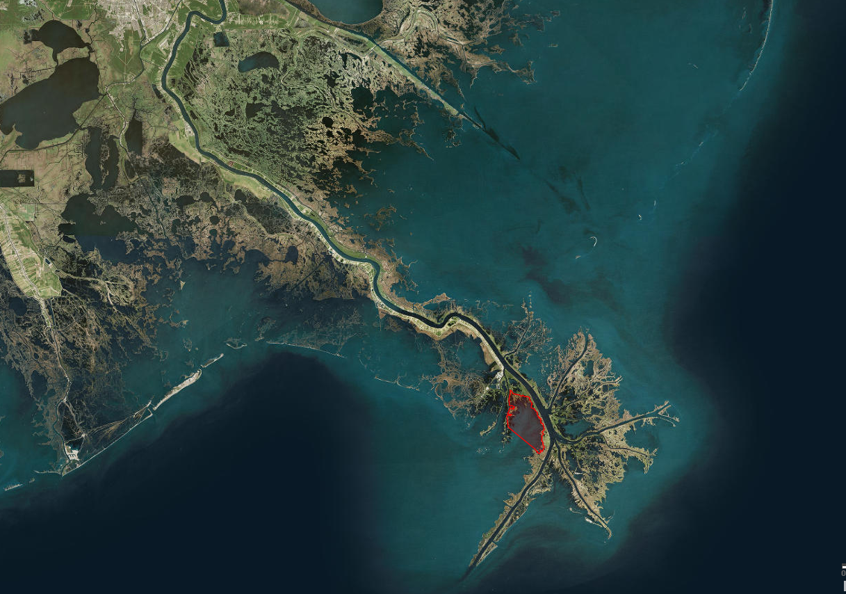
The West Bay diversion area is highlighted in red. Courtesy of the Coastal Protection and Restoration Authority.
In order to appease the maritime industry, CWPPRA signed a contract before the diversion was built that, if needed, they would pay to dredge the anchorage area. “And it did happen, three times,” Troutman said. “For construction [of West Bay], we only spent $4.8 million, I think. Some of those additional rounds of dredging were $8 to 12 million.” By 2008, engineers estimated the cost of dredging could exceed $140 million over ten years, the largest projected financial outlay for dredging that CWPPRA had ever considered.
The financial burden did not bode well for the project; nor did the data, which showed little or no land growth in West Bay. In 2008, CWPPRA voted to “close the West Bay Sediment Diversion project due to increases in cost associated with dredging the Pilottown Anchorage Area, which became too substantial for the scope of the CWPPRA program.” It looked like the first large-scale uncontrolled sediment diversion would go down in history as a failure.
Since the diversion opened in 2003, Armstrong was on the ground observing West Bay week in and week out. He knew that land was growing, though it was happening slowly. And he knew that West Bay was important to the survival of his home. “That’s when I went to Baton Rouge,” Armstrong said. “I just kept on them about it, because if they block [West Bay] off and call it a failure, we would never, ever, get nothing down here again.” Armstrong decided he needed to speak in front of the CWPPRA Task Force.On December 10, 2010, Armstrong walked into the Louisiana Department of Wildlife and Fisheries offices. Representatives from the US Army Corps of Engineers, the Environmental Protection Agency, Louisiana Coastal Protection and Restoration Agency, and other member agencies were gathered in the room. An Army Corps representative presented a plan to close West Bay. He reported that, after discussions with the State of Louisiana, no final data would be collected from West Bay because of the additional costs this would incur. The diversion would be closed in March 2011 at a cost of $10 to 20 million, which was around the same amount it cost to open it. At the end of this report, the floor was open to public comment.
It’s the people who live near these massive earth-changing projects who can provide insight into the daily fluctuations of natural systems.
Armstrong stood up and took the podium. He told the group that he grew up in Plaquemines and that the West Bay Diversion was “one of the best projects I have ever seen.” Armstrong explained that sand bars were accumulating only eleven months after the islands had been constructed from dredge material behind the cut. West Bay would fill in if more islands would be constructed. Armstrong added that, as sediment was increasingly trapped in the basin, it would reduce the amount of dredging required downstream. He concluded, “It would be a huge mistake to close the diversion.”
The task force responded that the reason for closure was not, ultimately, the project performance, but rather the legal obligation to pay for dredging. Rick Hartman from National Marine Fisheries Services explained, “The CWPPRA Program cannot afford to spend $20 million every three years for this dredging. In a few years there will be no money left to build new projects.”
Armstrong stood quietly for a few seconds as he considered his response. He told the task force, “The anchorage area is hardly being used. You all need to investigate this and ask more questions of the people claiming that the diversion is ruining the Pilottown Anchorage Area.” He added, “If this diversion is closed, no other diversion will be constructed in this area again. The well-being of the people of Plaquemines Parish should be considered.” As a final entreaty, Armstrong offered to take the CWPRRA Committee to the site in airboats free of charge.
Paul Kemp was at the meeting that day and was impressed with Armstrong’s eloquent advocacy in favor of the West Bay Diversion.
He remembered going into the meeting thinking, “Oh my God, we just got coastal restoration going here, and now we’re going to shut down our most ambitious project at great cost.” So he introduced himself to Armstrong afterwards, and said, “I want to go with you.”
Armstrong and Kemp went out to West Bay soon after, speeding to the new sandbars that had emerged behind the newly dredged islands. Kemp said that, with Armstrong’s airboat, he was easily able to get out to West Bay and see the changes for himself. “That’s when we started putting a scientific effort into reinterpreting the data that [CPRA] already had, and mapping some of the other features that weren’t really displayed very well in that data.” Kemp realized, through this work, that most of the sediment build-up downriver in the anchorage area was not a result of the diversion.
Kemp took his new data interpretation back to the next CWPPRA meeting, where the task force approved a work plan to study if sediment settling in the channel was in fact from the West Bay Diversion. Finally, in 2012, a crucial study by the Army Corps’ Engineering Research and Development Center indicated that West Bay contributed only 15 percent to the sedimentation of the navigation channel. The report found that the location of the anchorage area made it inevitable that silting would occur, and that even if the diversion were shut down, the area would continue to receive sediment. With this information, the CWPPRA project was no longer held responsible for the cost of dredging the area. Shortly thereafter, CWPPRA approved a vote to keep West Bay open and to monitor its land growth.

Cows graze in the shallow waters near the mouth of the Mississippi River in Lower Plaquemines Parish, 2015. Photo by William Widmer.
“I think that [West Bay taught] an important lesson,” Troutman said. “You’re not going to see land popping up on year two, or year four. It might be year ten before land really starts to pop up. It is not a linear process.”
Another vital aspect of West Bay’s success is that it has become an important model for future river diversions, providing knowledge and science for more complex projects, such as the $821.4 million construction of the Mid-Barataria Sediment Diversion, the largest of its kind in Louisiana, and soon to become the largest man-made controlled sediment diversion in the history of the world.
And Paul Kemp points out another lesson from West Bay: the impact of Armstrong’s efforts. It’s the people who live near these massive, earth-changing projects who can provide insight into the daily fluctuations of natural systems. For this reason, Kemp says, “It is important for people who care about particular areas, and who know a lot about them, to get very involved in these restoration initiatives.”
Towards the end of the day in Armstrong’s airboat, we saw a large, tan bull walking alone across the water, his hooves breaking the shallow waves. Armstrong recognized the bull and, using the airboat, herded him back towards the other cattle. Armstrong is a cowboy, but with little land. Though earth is growing in West Bay, Armstrong knows he will have to adapt to the encroaching seas still reaching towards his home in Plaquemines.
He smiled as he said, “You lose land, you lose land, you lose land. Well, we gaining land now!”