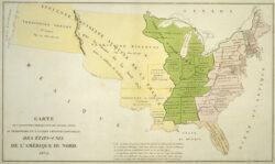
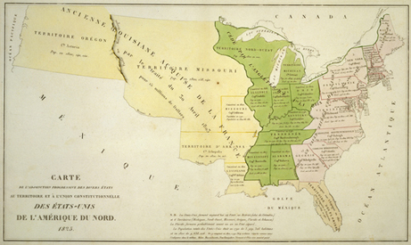
Carte de l'adjonction progressive des divers etats au territoire et a l'union constitutionelle des Etats Unis de l'Amerique Du Nord
1825 hand-colored French engraving of the North American map, showing United States expansion, including an area identified as "former Louisiana acquired from France by the treaty of 30 April, 1803, for 15 million dollars.”
Courtesy of The Historic New Orleans Collection
Carte de l'adjonction progressive des divers etats au territoire et a l'union constitutionelle des Etats Unis de l'Amerique Du Nord. Unidentified
Additional Data
| Courtesy of | The Historic New Orleans Collection |
| Date | 1825 |
| Copyright | Copyrighted |
| Disclaimer | The Louisiana Endowment has included this work in 64parishes.org for the purposes of criticism, comment, teaching, scholarship, educational research, all other nonprofit educational usages under Section 107 of the U.S. Copyright Act. Physical rights are retained by the Historic New Orleans Collection. Rights are held in accordance with the U.S. copyright laws. |