Los Adaes Archaeological Map 1767
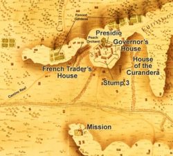
In 1767 cartographer Joseph de Urrutia produced this map of Los Adaes and its surroundings for the Spanish colonial government during an inspection of Texas presidios. Archeologists excavating the Los Adaes site near Natchitoches have found it to be an accurate guide to the settlement's layout.

Courtesy of Wikimedia Commons
Los Adaes Archaeological Map 1767. Joseph de Urrutia (illustrator)
Additional Data
| Courtesy of | Wikimedia Commons |
| Date | 1767 |
| Copyright | Public Domain |
| Disclaimer |
The Louisiana Endowment has included this work in 64parishes.org for the purposes of criticism, comment, teaching, scholarship, educational research, all other nonprofit educational usages under Section 107 of the U.S. Copyright Act. |