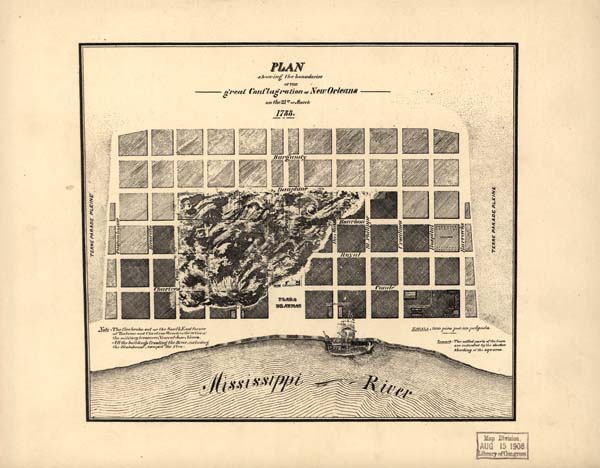
Plan showing the boundaries of the great conflagration of New Orleans on the 21st of March 1788
An illustrated map showing the boundaries of the great conflagration of New Orleans on the 21st of March 1788. Settled parts of the town are illustrated with darker shading. This map also indicates where fire started and which buildings escaped the fire.
Courtesy of Library of Congress, Geography and Map Division
Plan showing the boundaries of the great conflagration of New Orleans on the 21st of March 1788. Unidentified
Additional Data
| Courtesy of | Library of Congress, Geography and Map Division |
| Date | Unidentified |
| Copyright | Copyrighted |
| Disclaimer | The Louisiana Endowment has included this work in 64parishes.org for the purposes of criticism, comment, teaching, scholarship, educational research, all other nonprofit educational usages under Section 107 of the U.S. Copyright Act. Fair Use Rational: It is believed that the use of this image in the English-language 64parishes.org website to illustrate a section of the article on the person(s) depicted falls under the "Non-profit educational" clause of the Fair Use doctrine currently upheld by United States law. Owing to the limited web-resolution of the image, only a small portion of a copyrighted work is used. For the same reasons, the portion of the copyrighted work used is of inherently lower quality than the original, reducing the risk of competitiveness and therefore the effects of this copy on the market for or value of versions held by the owner of the copyright. |