Satellite View of Hurricane Rita
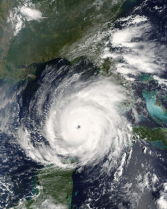
Rita was building into an extremely dangerous hurricane when NASA’s Terra satellite captured this image at 12 pm US Eastern time on September 21, 2005. The storm is compact and circular, with an open eye through which the deep blue waters of the Gulf of Mexico are visible. Within a few hours, the storm intensified to a Category 5 hurricane with sustained winds of 165 mph.

Courtesy of Wikimedia Commons
Satellite View of Hurricane Rita. Jacques Descloitres
Additional Data
| Courtesy of | Wikimedia Commons |
| Date | 2005 |
| Copyright | Public Domain |
| Disclaimer | The Louisiana Endowment for the Humanities has included this work on 64parishes.org for the purposes of criticism, comment, teaching, scholarship, educational research, and all other nonprofit educational usages under Section 107 of the U.S. Copyright Act. All rights reserved by Wikimedia Commons. |