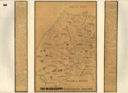
The Mississippi
A color reproduction of a hand drawn map of the Mississippi River. Created by Jean Baptiste Louis Franquelin, ca. 1682, it is one of the earliest—if not the first—French map ever created of the Mississippi.

Courtesy of Library of Congress, Geography and Map Division
The Mississippi. Franquelin, Jean Baptiste Louis (mapmaker)
Additional Data
| Courtesy of | Library of Congress, Geography and Map Division |
| Date | 1682 |
| Copyright | Public Domain |
| Disclaimer |
The Louisiana Endowment has included this work in 64parishes.org for the purposes of criticism, comment, teaching, scholarship, educational research, all other nonprofit educational usages under Section 107 of the U.S. Copyright Act. |