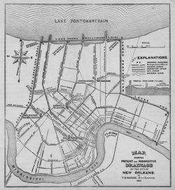
The Topography and Drainage of New Orleans
In 1875, city surveyor T. S. Hardee made this map showing present and prospective drainage of the city of New Orleans, related to the slaughterhouse property in the city's Lower Ninth Ward.

Courtesy of The Historic New Orleans Collection
The Topography and Drainage of New Orleans. Hardee, T. S. (Mapmaker)
Additional Data
| Courtesy of | The Historic New Orleans Collection |
| Date | 1875 |
| Copyright | Copyrighted |
| Disclaimer |
Physical rights are retained by the Historic New Orleans Collection. The Louisiana Endowment has included this work in 64parishes.org for the purposes of criticism, comment, teaching, scholarship, educational research, all other nonprofit educational usages under Section 107 of the U.S. Copyright Act. |