La Salle Expeditions
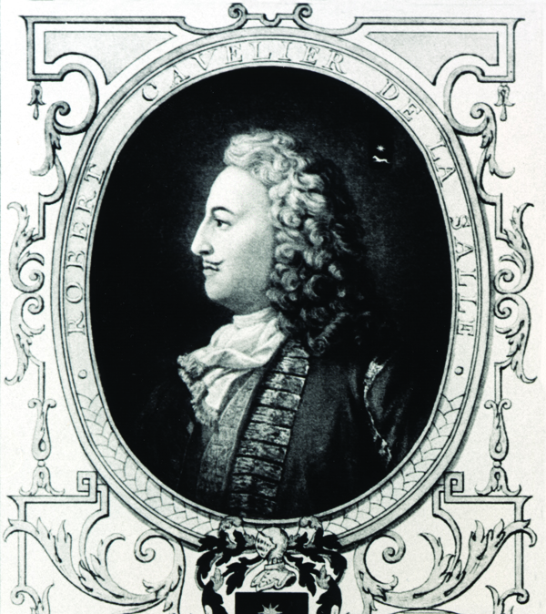
René-Robert Cavelier, sieur de La Salle, led two expeditions in search of the Mississippi Rivers outlet to the Gulf of Mexico for France under King Louis XIV.

Courtesy of The Historic New Orleans Collection
Rene-Robert Cavelier, sieur de La Salle. Goupil and Company (Publisher)
During the 1680s, René-Robert Cavelier, sieur de La Salle, led two expeditions in search of the Mississippi River’s outlet to the Gulf of Mexico. Jacques Marquette and Louis Joliet preceded La Salle by a decade, though they only went as far as the Arkansas River before returning to Canada. In 1682 La Salle’s first expedition traveled down the Mississippi River and reached its mouth. His second expedition, begun in 1684, was a disaster, ultimately resulting in the deaths of La Salle and most of the settlers. Despite setbacks, the La Salle expeditions provided the French government with information about the geography and native population of the Mississippi Valley and Gulf Coast that would prove essential to the future settlement of lower Louisiana in 1699.
First Expedition
Prior to his expeditions, La Salle, along with Louis de Buade, comte de Frontenac et de Palluau, received a fur trade monopoly in the Illinois Country. Though the trading scheme produced little profit, La Salle managed to identify the falls of the Ohio River near present-day Louisville, navigate Lake Michigan, and expand upon the knowledge of the land and peoples in the vicinity of the Illinois River during the late 1660s and early 1670s. Afterwards, La Salle shifted his attention to the development of colonies further south, along the great river that would later be named the Mississippi. Joined by his lieutenant Henri de Tonti and a party of approximately forty Frenchmen and Native Americans, La Salle finally entered the waters of the great river in February of 1682. They built temporary stockades at Fort Prudhomme (near present-day Memphis) and on the Arkansas River. On April 9, 1682, at the junction of the bird-foot delta near the Gulf of Mexico, La Salle claimed the river and its drainage basin for King Louis XIV, hence the name “Louisiana.” In addition, he named the river Colbert in recognition of his patron and French finance minister Jean-Baptiste Colbert. He then calculated what he thought was the mouth’s latitude, returned northward to Canada, and started planning for the establishment of a colony on the Colbert River.
Second Expedition
On their return trip to Canada, La Salle left Tonti in charge of a fur-trading post on the Illinois River. While waiting for La Salle to return from a fundraising trip in France, Tonti established another trading post on the Arkansas River. There Tonti developed a relationship with the Quapaw Indians and provided French and Canadian travelers with a midway station between the Illinois Country and the anticipated colony to be founded by La Salle’s second expedition.
Tonti wrote an account of the first La Salle expedition for a French minister in 1693, which was later expanded, plagiarized, and made into a book entitled Dernieres decouvertes dans l’Amerique Septentrionale de m. de La Sale mises au jour par m. le chevalier Tonti, gouverneur du Fort Saint Louis, aux Islinois (1697). Tonti denied authorship. Like the accounts of the Recollect missionary Zénobe Membré and other writers, much of the information in Tonti’s book is unreliable, though it does provide insight into how the French viewed life on the Mississippi during the late seventeenth century.
La Salle secured a contract for the colonization of lower Louisiana from Louis XIV in 1683. The plan was to reach the Mississippi by sea and secure a permanent settlement upriver that would provide the French with a strategic advantage over Spanish interests throughout the Gulf of Mexico. Two years later, La Salle’s small fleet left the French port of La Rochelle, carrying roughly one hundred soldiers, as well as 280 men, women, and children, and a year’s worth of supplies. They stopped at the French island Saint Domingue before making landfall somewhere between Grand Isle and the Atchafalaya Bay in December 1684. By this point, the expedition had lost the ketch Saint François to Spanish privateers.
Due to a latitudinal miscalculation and severe dissension among the crew, the second La Salle expedition continued west until reaching the entrance of Matagorda Bay in present-day Texas. La Salle sent one ship back to France with news of the colony’s uncertain future. He then led three overland expeditions in search of the missing Colbert River. Most of his companions either died or deserted during the first two trips. In 1687, on the third attempt, several men murdered La Salle and continued moving east until they reached the Arkansas River and then traveled onward to Canada and France. A Spanish search party found the abandoned Matagorda colony in 1689 and surmised that local natives had killed or captured all of the French colonists.
Historians continue to debate how La Salle could have missed the Mississippi River and mistakenly landed in Texas. Still more mysterious is the actual fate of those who joined La Salle on his second expedition and remained at Matagorda Bay. Regardless, the La Salle expeditions represented the first penetration of European explorers into the Gulf Coast of Louisiana and Texas since the sixteenth-century expeditions of Pánfilo de Narváez and Hernando de Soto. In 1995, the story of La Salle’s ill-fated voyage made headlines when archaeologists of the Texas Historical Commission discovered what remained of La Belle, shipwrecked in 1686 and excavated more than three hundred years later.
