Coastal
Fishing for Answers
Charter captains debate the impacts of the Master Plan and the future of Louisiana's coast.
Published: August 27, 2018
Last Updated: March 22, 2023
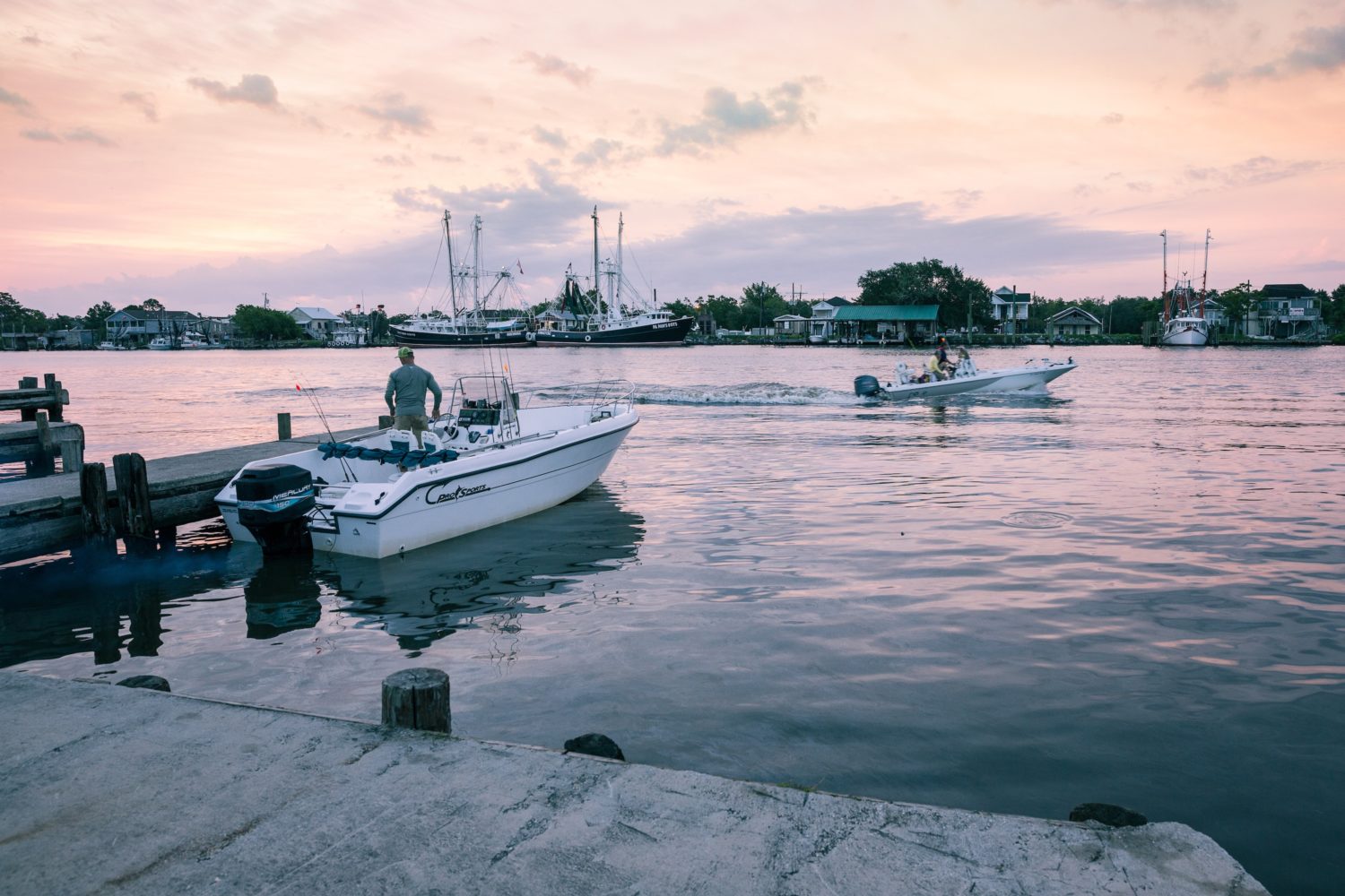
Photo by Rick Olivier
Morning at Joe's Landing in Lafitte.
But the state’s roughly 1,000 registered charter-fishing captains (up from 644 just eight years ago) represent a large, and growing, economy—especially when lumped into the bigger category of recreational fishing, or the behemoth, tourism—and they face as many struggles as anyone else whose livelihood depends upon Louisiana’s coastline.
Charter captains are currently still deciphering the newest Coastal Master Plan introduced by Coastal Protection and Restoration Authority (CPRA) in 2017. The Master Plan details 124 projects (79 restoration, 13 structural protection, and 32 nonstructural risk-reduction projects) that will hopefully build and protect more than eight hundred square miles of new land over the next fifty years. “In Louisiana, no two places are the same—there’s a lot of difference just within one or two miles,” Bren Haase of the CPRA pointed out, “which is why we expend so much effort in planning: there is no one answer or solution for our entire coast.”
Depending on whom you speak with in which coastal Louisiana town, the Master Plan’s projects will either ease fishermen’s woes, or deepen them.
Charter captains are split regarding the Master Plan’s five billion dollars’ worth of diversion projects, which fall under the restoration category. Sediment diversions, in this case, mean channels cut into levees and along the Mississippi River. These cuts allow river silt to flow into brackish and saltwater bayous and ponds where, for decades, the land has been sinking and the marshes disappearing. These Mississippi diversions do build the marshland up, but the accompanying fresh river water dilutes the salt water, which greatly effects ecosystems—for good and for bad, depending on your occupation.
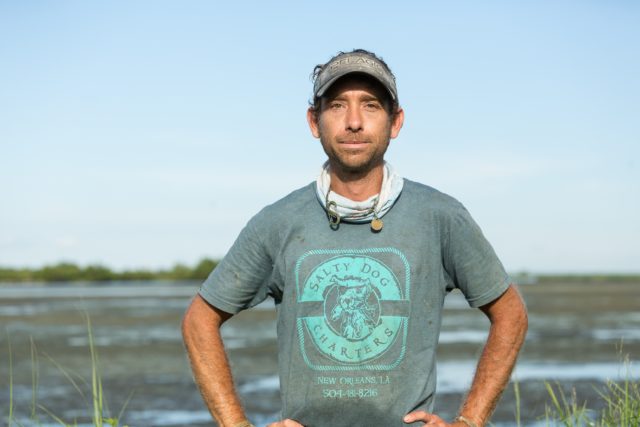
Captain Markham Dickinson of Salty Dog Charters, Shell Beach. Photo by Rick Olivier
“I started fishing Shell Beach when it was salty,” Dickson said. “Then [in 2009] they dammed the MRGO, which lowered the salinity.” Still one of the saltier areas within driving distance of New Orleans, Shell Beach now sits in the projected potential impact area of the Master Plan’s scheduled Central Wetlands Diversion and Mid-Breton Diversion, which will allow hundreds of thousands of gallons of fresh water into the Shell Beach area each second.
“While the fresher water does create more hydrilla plants, which keeps the waters nice and clean,” said Dickson, “on the banklines where you would catch redfish, you are now catching largemouth bass and a lot of brim instead.”
Captain Ron “Ahab” Broadus, who has explored the massive, complex Delacroix marsh system east of the Mississippi for almost thirty years, prefers to put his clients on speckled trout. “You can always catch redfish all year around in Delacroix,” he claimed, explaining that trout are much pickier hunters, who follow the salty water for breeding reasons, and also because salt clarifies the water, making prey more easily visible. Freshwater and silt diversions, of course, muddy the waters for the sake of building land.In 1991, Louisiana built the Caernarvon Diversion fifteen miles south of New Orleans with support of Breton Sound oyster fisherman who were convinced that the salt influx would eventually kill off their industry. From 1992–1994, research by the Louisiana Department of Natural Resources Coastal Restoration Division showed a net increase in marshland of 406 acres, but the structure—a freshwater diversion, not a sediment diversion—successfully freshened the water.
Then in 2012, the Mississippi broke through the natural levee on its own, creating the Mardi Gras Pass, which still pushes river water into Breton Sound. “The river over time has started eating away at Mardi Gras Pass, where now it’s like a hundred feet wide, and something like thirty feet deep,” said Broadus of the pass. “So much freshwater is being pushed straight from the Mississippi, and there are no controls.”
The oyster industry recently spent two hundred thousand dollars creating a study, hoping to gain approval from the Louisiana Department of Natural Resources and the US Army Corps of Engineers to close up Mardi Gras Pass. That may be a tough sell, since Mardi Gras Pass has already been proven to be building land, and is substantially benefitting several upcoming Master Plan projects in the area, including the Breton Sediment Diversion and the Breton Marsh Creation project, which is expected to create twelve thousand acres of marsh in Uhlan Bay.
Like many fishermen who prize the saltwater, Broadus would rather see sand dredged from the river to rebuild land in the marsh—a much more expensive procedure. Either way, he understands that something must be done. “If I get a guy I took out last year, and helped him and a friend bring home seventy-five trout and fifteen reds, and now this year the only thing you can offer him today is redfish, they’ll say, ‘We’ll wait.’ So the freshwater is having an economic impact.”
Captain Maurice d’Aquin on his boat near Lafitte. Photo by Rick Olivier
And so, d’Aquin also welcomes the scheduled Mid-Breton and Mid-Barataria diversions, recently fast-tracked for permitting, with two more diversions (Lower Breton and Lower Barataria) still in the planning processes for the area. “Wetland loss has the biggest impact on the charter captains’ way of living,” said d’Aquin. “Out here you see it directly. After one storm, you can see that we’ve lost forty or fifty yards of coastline. Fishing camps on the edges that I stayed at back when I was a kid are already gone. We are soon gonna be fishing open bays, and it’s just not gonna be the same.”
D’Aquin is happy to focus on Lafitte’s abundant redfish, which don’t seem to mind the fresh water—whereas trout already generally avoid Lafitte’s abundant fresh water most of the year, especially in the warmer months. “The trout will still move in to some of these fresh water ponds though,” d’Aquin said with confidence. “Lake Salvador is pretty fresh, and trout will move in there when it’s winter and they’re looking for warmer, deeper water.”
Down the coast to the east of the Mississippi, residents of Buras, Louisiana, don’t worry as much about losing the marsh.
“The marsh is gone,” declared Captain Ryan Lambert, head of Cajun Fishing Adventures. When Lambert began his business thirty-nine years ago, the Buras marshes stretched along the southwest of the Mississippi near Venice. Today it is open water. “From the seventies to the nineties, we fished almost 100 percent on the west side of the river. But we lost that fishery. With no more land marsh, juvenile fish don’t have vegetation to hide in, and the whole system has collapsed, because we cut off the river from the estuary by building all the levees. So now we fish mostly the east side of the river.
“Buras is gone,” he repeated, “and Sulphur is coming right behind it.”
Having suffered the loss of thousands of acres of marshland firsthand, Lambert does not prioritize saltwater over marshland, and like d’Aquin in Lafitte, welcomes the planned Mid-Barataria Diversion, which would send a maximum of seventy-five thousand cubic feet per second of sediment and river water into Barataria Bay, with the hopes of building and maintaining about thirty thousand acres of coastal wetlands. “You want the river flowing in to keep building land, keep the marshes from sinking, and also to keep that salt at bay. If you don’t have that freshwater pushing against it, the saltwater all creeps inland—it’s a hundred miles inland now. As a result, we lose like sixteen square miles of land a year.”
Fishermen operating out of Grand Isle, Louisiana’s “Gateway to the Gulf,” say they’ve benefitted from the Master Plan’s biggest success so far, the $216 million dollars in repairs to the nearby Caminada Headland. “We lost a massive beachhead there in a storm a few years back,” said Captain Daryl Carpenter. “But the CPRA did a gorgeous job restoring it with dredged sand.”
Still, with saltwater eating away at Grand Isle’s already sparse vegetation, the area remains especially vulnerable to even mild Louisiana storms. Whereas most fishermen might consider ten-mile-per-hour winds a slight inconvenience, Carpenter said, “Grand Isle is all open bays now, and if we get a ten-mile-per-hour wind it’s rough as hell, and I don’t want to take customers out.”
Along with the planned $882 million Ama Sediment Diversion, which will bring fresh river water into Louisiana’s saltiest fishing spots, the CPRA is also planning an ambitious barrier-island project that will span from Venice to Cocodrie, protecting both Jefferson and Plaquemines Parishes.
Most of the Master Plan’s projects are expected to be completed within the next eleven to thirty years. Until then, said Carpenter, “the storms are moving our estuaries north, and the fishermen are following them. We have plenty of places to hide if we go north of here. But then when you finally find a safe place to fish, some jackleg comes along and says, ‘Hey you’re trespassing in my private water!’”
This year, Louisiana Representative Kevin Pearson (R-Slidell) filed HB 391 for consideration by the House Committee on Civil Law and Procedure, hoping to end any and all private ownership over any of Louisiana’s waters, or the wild aquatic life beneath them. HB 391 died in the legislature, but the issue isn’t dead. It helps make Carpenter skeptical regarding the Ama Diversion. “They’re gonna spend billions of public dollars to do all these diversions, and then when that new land gets built, who owns it?” he wondered. “There have been cases where they’ve spent hundreds of millions in public money, rebuilding [land in Louisiana], and then as soon as they finished, they turned around and handed the keys to private owners who said to us charter captains, ‘Y’all can’t come in no more, this is private.’”
Photo by Rick Olivier
The CPRA’s Atchafalaya River Diversion will affect the Dulac area and benefit the Penchant Basin and the Southwest Terrebonne marshes, as well as supporting the South Terrebonne Marsh Creation Project and the Central Terrebonne Hydraulic Restoration Project. The fresh water from the river pushes back against encroaching salt water, keeping it a safe distance from delicate marshland.
Over in Cocodrie, the CPRA decided to begin with a major study first: the $90 million Terrebonne Bay Rim Marsh Creation Study of the northern halves of Lake Barre, Lake Felicity, and Lake Chien. But until something concrete is done to protect the Cocodrie marshes, Carpenter puts faith in his fishing skills: “The fish have gotta go somewhere, and we will find them,” he said. “We charter fishermen aren’t going to completely disappear, we’re just definitely gonna lose places where we used to fish at.”
In southwestern Louisiana, the port in Cameron is situated thirty-five miles inshore, technically in the city of St. Charles. “So, the big thing here in Cameron is the dredging of that ship channel that connects the lake to the open water. And that canal’s where we’re experiencing land loss,” said Captain Erik Rue of Calcasieu Charter Service, who helped start the Louisiana Charter Boat Association. He said the mud being drawn out of the marshes from the dredged ship channel is covering and killing oyster reefs and reducing fish habitat. It also brings saltwater and storm surges inland, which degrades marshland.The Army Corps of Engineers was given another $103 million to upkeep and continue dredging the canal. “Thing is, though, the bigger they dredge the channel, the more ships and the more business they can get through there,” Rue said. “So, it’s tough to say how that affects my industry. When it comes to eroding areas and reducing habitat, of course it reduces the quality of your fishery, but then the increase in the business probably puts more money in the local economy, and you’d think there’d be more customers for us charter captains.”
With no diversions keeping saltwater at bay, Cameron has lost acres of interior wetlands over the last several decades. As such, a $450 million project from the Master Plan is set to begin in 2022, with the aim of lowering salinity levels in the marshes. The Calcasieu Ship Channel Salinity Control Measures will construct sill and wall structures to keep saltwater in the channel and prevent intrusion in the surrounding wetlands. Several marsh creation projects around the banks of Calcasieu Lake will ostensibly create tens of thousands of acres of new land.
Rue said he’s more worried about “a different kind of land loss,” alluding to the private waters issue. Despite all the projects in the works, it is easy for Rue and other charter captains who are out on the water every day, watching land and fish habitats disappear and shift, to feel as though their options are shrinking in the distance. “The industry has grown, and there are a lot of people out fishing, so we’re all out here looking for new water, always,” said Rue. “The pie is getting sliced smaller and smaller over time—and that’s everywhere down the coast.”
Musician and journalist Michael Patrick Welch has covered New Orleans for coming on twenty years. He has authored several books, and his writing has appeared on the front page of every local paper, as well as in The Guardian, Vice, Vox, Columbia Journalism Review, McSweeney’s, and many other fine national publications.