Looking Down on Creation
Ben Depp is the Documentary Photographer of the Year
Published: May 31, 2024
Last Updated: September 1, 2024
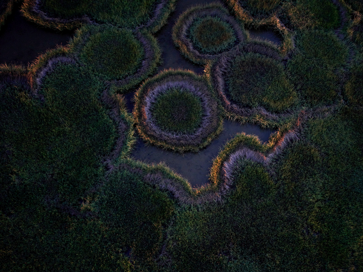
Photo by Ben Depp
Colorful grass circles in the morning light on Pelican Island, a barrier island that was restored in 2007. Almost 3.4 million cubic yards of sand and silt were mined from a borrow pit in the Gulf of Mexico to restore 230 acres of beach, dunes, and berm.
Southern Louisiana, once formed by sediment deposited by the Mississippi River, is now rapidly eroding. Over the past eighty years, Louisiana has lost two thousand square miles of wetlands, accounting for 90 percent of the coastal marsh loss in the United States.
Louisiana’s wetlands provide a natural barrier from hurricanes and storm surges that protects 70 percent of the state’s population. The wetlands are a biodiverse landscape containing interconnected habitats, from freshwater cypress forests to salt marsh to sand beaches, supporting millions of fish and birds and other wildlife. It is the winter home of many migratory birds, and a rest stop for others before and after they cross the Gulf of Mexico. The Mississippi River supports billions of dollars of economic activity, driven by hundreds of refineries and chemical plants along the river, and by the international shipping industry, which relies on channels that cut through South Louisiana.
Because much of South Louisiana is remote and difficult to access, little visual documentation of the area exists beyond maps and satellite images. Few people see this landscape other than from boats or from commercial airliners twenty-five thousand feet overhead. When I first saw from a commercial airline flight how surreal and beautiful South Louisiana is from above, it occurred to me to try to tell the story of coastal erosion in a new way with aerial photographs. I learned to fly a powered paraglider and built a wooden sailboat to access Louisiana’s barrier islands.
A powered paraglider may be the world’s smallest aircraft. I wear a motor with a propeller on my back with a paraglider wing overhead. I usually launch half an hour before sunrise or two hours before sunset. With the paraglider, I can fly between fifteen feet to ten thousand feet in the air. I rarely go out with a plan to photograph a specific place or thing. I spend hours in the air, camera in hand, waiting for the brief moments when the first rays of sunlight mix with cool predawn light and illuminate forms in the grass, or when evening light sculpts fragments of marsh and the geometric scars of human enterprise—canals, pipelines, and roads.
Even after hundreds of flights, each flight is still simultaneously exhilarating and a little terrifying. I love to be a few hundred feet up over the wetlands and watch the colors change in the marsh as the sun rises. In my photographs, one can make out varieties of plants; see weather and seasonal changes from the shifting high-water line, color temperature, and softness of light; distinguish living cypress trees from those that have been killed by saltwater intrusion; and see the patterns made by wave energy on barrier island beaches.
Although I have been a photographer for almost twenty years, I’ve found my photographic voice through this project, which I started in 2014. By slowing down, spending days at a time camping, traveling slowly by sailboat and powered paraglider, I am seeing the natural world around me more clearly. The photographs I now make reflect my increased connection and sensitivity to this place. Through my photographs, I hope that people who have not experienced South Louisiana can begin to see the beauty and value of this landscape and better understand what we are losing.
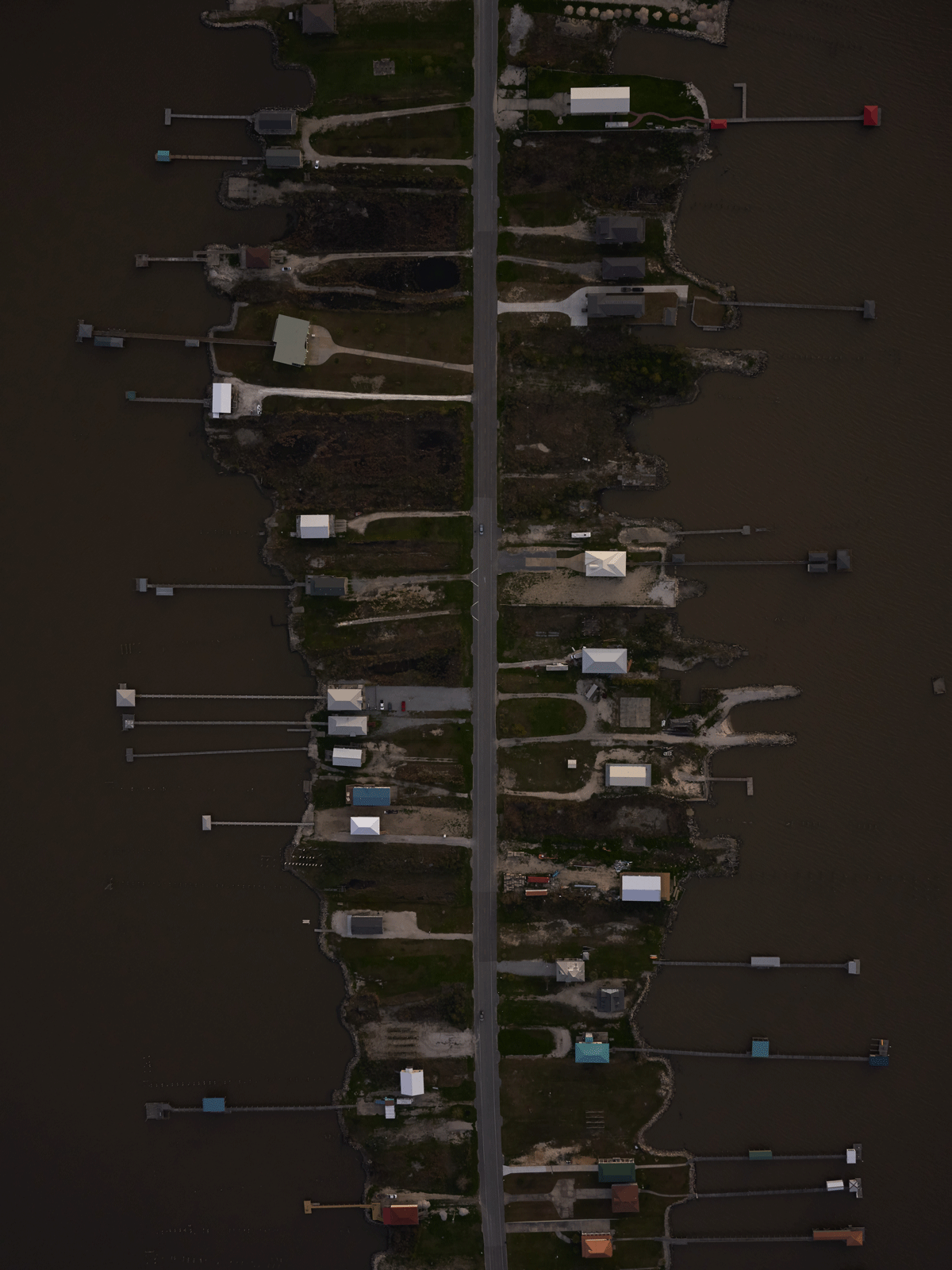
Highway 90, Orleans Parish. Photo by Ben Depp.
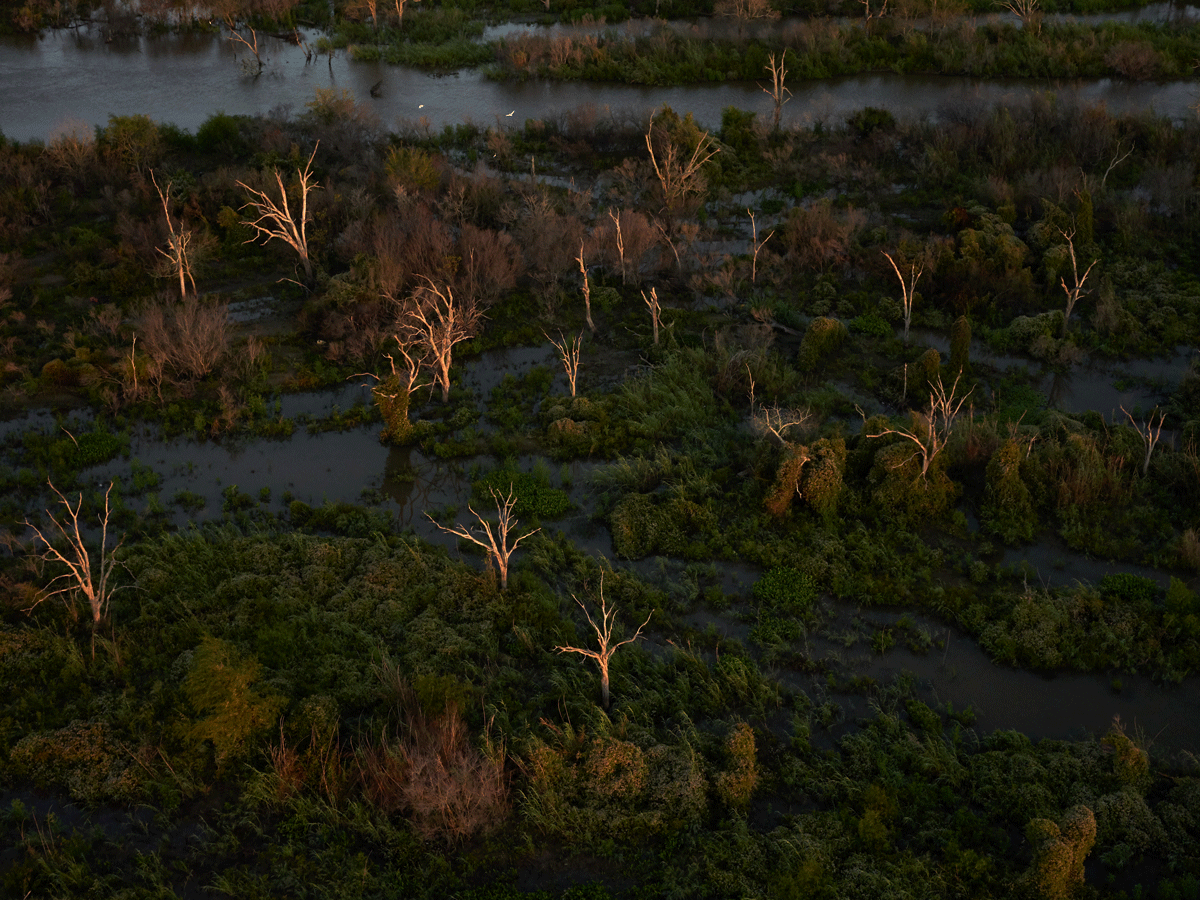
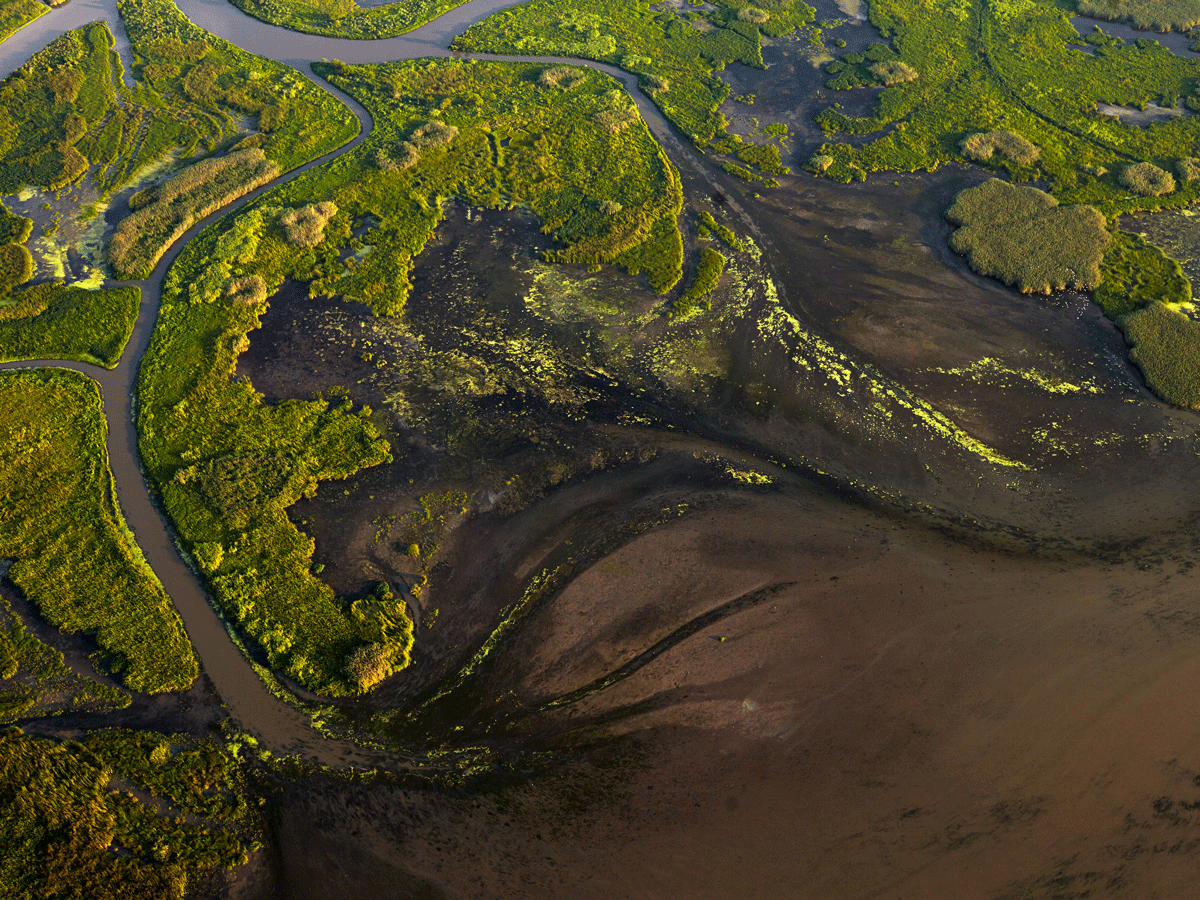
Wetlands near Mardi Gras Pass, Plaquemines Parish. Photo by Ben Depp.
A view of the beach in Cameron Parish. Photo by Ben Depp.
In the last century Bayou Dupont in Plaquemines Parish was healthy wetlands. Now it is open water except for where dirt was piled on the edges of canals dug by the oil industry. Photo by Ben Depp.
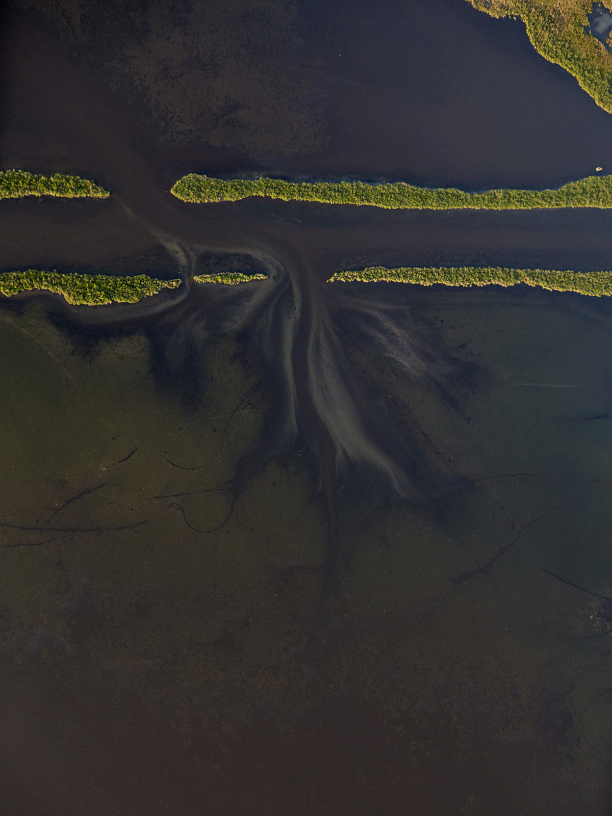
Sediment from the the Mississippi River is deposited into the wetlands at Fort St. Philip, Plaquemines Parish. Photo by Ben Depp.
Ben Depp is an artist based in New Orleans. Depp’s work is in the permanent collections of the Ogden Museum of Southern Art and The Historic New Orleans Collection. It has been shown at the Walter Anderson Museum, Louisiana State Museum, Ogden Museum of Southern Art, and more. Photographs from this project have been published by National Geographic, Smithsonian, Audubon, Scientific American, and Photography Forum, among others. To see more of Depp’s photographs, visit Ann Connelly Fine Art in Baton Rouge or Claire Elizabeth Gallery in New Orleans.
![]() Restore the Mississippi River Delta is a coalition of Environmental Defense Fund, National Audubon Society, the National Wildlife Federation, Coalition to Restore Coastal Louisiana, and Pontchartrain Conservancy. Together, we are working to rebuild coastal Louisiana’s nationally-significant landscape to protect people, wildlife and jobs.
Restore the Mississippi River Delta is a coalition of Environmental Defense Fund, National Audubon Society, the National Wildlife Federation, Coalition to Restore Coastal Louisiana, and Pontchartrain Conservancy. Together, we are working to rebuild coastal Louisiana’s nationally-significant landscape to protect people, wildlife and jobs.
