Fall 2024
Louisiana’s Place in the Below-Sea-Level World
Notes on a topographic peculiarity
Published: September 1, 2024
Last Updated: December 1, 2024
Richard Campanella
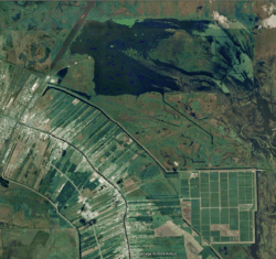
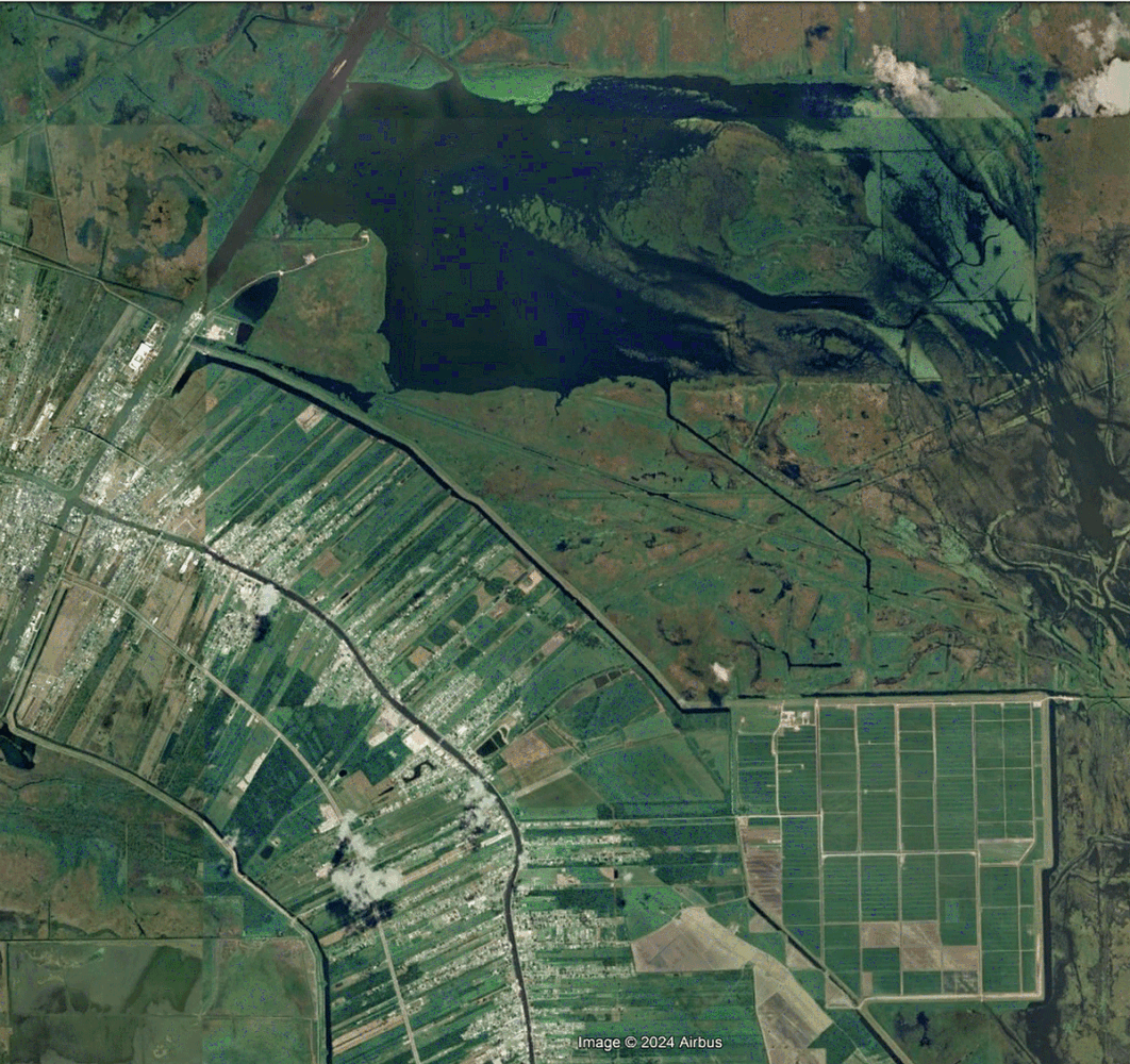
This recent satellite image shows how Delta Farms (at top) has filled with water, the consequence of its levee having failed, and its terrain having subsided below sea level. Clovelly Farms, at lower right, which remains in operation, sits at 4.5 to 6.5 feet below sea level.
Below sea level” is a peculiarity of Earth’s lithosphere. The very notion of “land” implies a preponderance of soil over water, and one might presume, of soil being above water. But under two circumstances, the apparent absurdity becomes possible. One is natural—that is, geological in origin—and the other is anthropogenic, the product of human tinkering.
Troughs in the Earth’s surface tend to form where tectonic plates converge or diverge. If the clash occurs in coastal areas, the resulting depression usually fills with seawater, becoming an embayment; if it occurs in a wet region, it would likely collect runoff and form a lake. In either case, we would consider the spot to be a waterbody—not terrestrial, and thus not below sea level (i.e., the mean level of the world’s oceans). But if the tectonic plates clash in an arid interior region, the resulting trough will likely remain dry, even as it may dip hundreds of feet below sea level.
Only a few such spots exist around the planet, and they tend to be sparsely populated. The premier example in the United States is California’s Death Valley, which bottoms out at 282 feet below sea level, and whose basin extends some four thousand square miles into Mexico’s Salton Trough. Five times deeper is the Jordan Rift Valley (Syro-African Depression) along the Israel–Jordan border, a desert trough some two hundred miles in length and lying as deep as fourteen hundred feet below sea level. The little water that accumulates within this landlocked concavity has no outlet, so its evaporation leaves behind intensely concentrated salt—Earth’s deepest hypersaline waterbody, the Dead Sea, which is surrounded by its lowest land.
Louisiana has no below-sea-level areas traceable to natural geological processes. Though we do have sedimentary faults, we have no tectonic faults, and our hydrology, rainfall, and coastal position all ensure that any natural depression would immediately fill with water.
What Louisiana does have is that other type of below-sea-level land, that which is caused by human engineering. Compared to geological low spots, our anthropogenic bowls tend to be smaller in spatial extent and shallower in depth, typically spanning a few dozen or hundred square miles, and lying three to fifteen feet below sea level. But they pose greater risk, because they tend to be inhabited by humans and abutted by tidewater—that is, coastal marshes, lakes, bays, or other waterbodies adjoining the Gulf of Mexico.
Our anthropogenic bowls are relatively new. Prior to the late 1800s, all of Louisiana lay above the level of the sea, albeit barely in its marshy fringes. The Mississippi River, over seven millennia of avulsions and overtopping, deposited alluvium at a pace faster than gulf tides and longshore currents could sweep it away, creating deltaic lands a few feet above sea level. If the river channel shifted away, the abandoned deltaic lobe would gradually fray and subside back into the sea. But so long as new dosages of sediment-laden water arrived, existing marshes would trap incoming sediment particles and rise slightly higher in elevation. Under no conceivable natural condition could Louisiana’s coastal lands drop below sea level and still remain dry land.
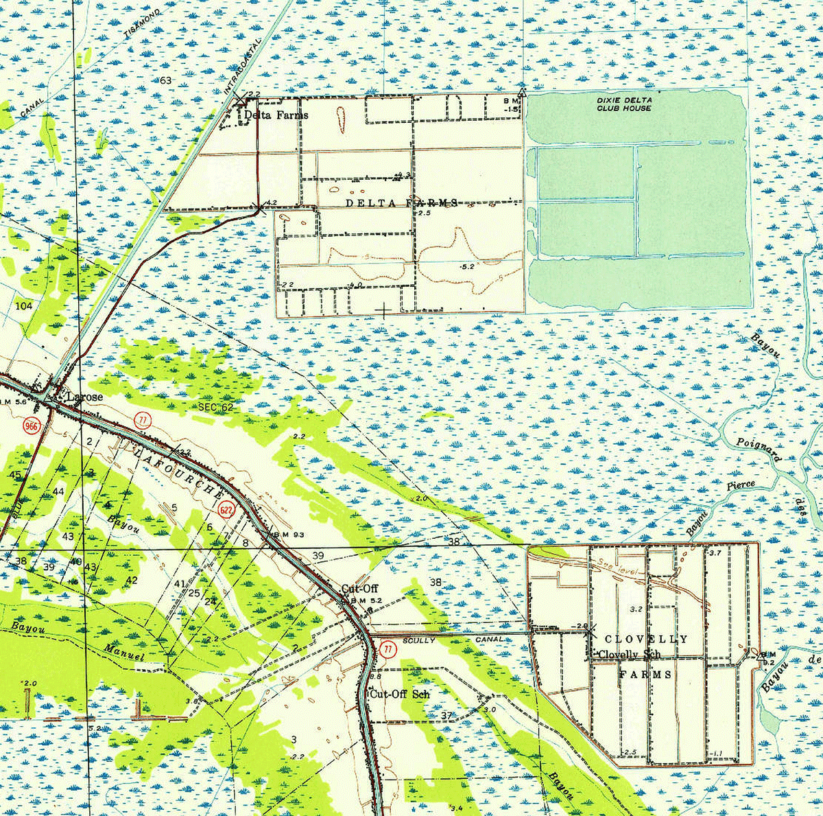
This subset of a 1941 US Geological Survey map shows Delta and Clovelly Farms reclaimed out of the marshes east of Larose in Lafourche Parish. Richard Campanella
So what happened in the late 1800s to change that? Two things: back levees and mechanized drainage.
A back levee is an embankment built along the rear of a low-lying basin, typically through swamplands or marsh. As opposed to a front levee, which is an embankment built along a river or bayou to prevent overtopping, a back levee aims to circumscribe an expanse of lowlands and turn it into a discrete hydrological bowl with a finite amount of impounded water. Whereas front levees in Louisiana date as far back as 1719, back levees are mostly a product of the mid-1800s through early 1900s.
Once a swamp is encircled with back levees, then some sort of mechanized device—steam paddles in the early years, later vertical-displacement pumps—may be installed at a low spot in the rear of the bowl, such that standing water as well as stormwater runoff and soil water may be amassed, raised, and ejected into an outfall, meaning a waterbody beyond the back levee, usually a swamp, lake, bayou, or canal.
Areas inside the artificial bowl thus dry out and become useful for human activity—logging, farming, ranching, industry, infrastructure, or residential development. As if to laud the conversion of “useless” wetlands to productive land, we termed this process “reclamation,” implying that the space had been there all along for us to claim; we just had to endeavor to re-claim it.
But reclamation in a place like coastal Louisiana comes at a cost. Once the water is removed, cavities open up in the desiccated soil body, and the pockets of air act to oxidize the organic matter, causing it to shrink and open up additional cavities. Sand, silt, and clay particles settle into those air pockets, and the soil body begins to consolidate and subside, to the point of dropping below sea level.
That’s what New Orleans had unknowingly “achieved” in the late 1800s, by which time some combination of back levees, canal-side guide levees, and/or natural ridges had rimmed the backswamp, and primitive pumps had managed to draw down some standing water. In 1895 surveyors working for the municipal Advisory Board on Drainage mapped city elevations at one-foot contours, including in soggy bottomlands, creating a beautiful topographic map that would be used for years to come. The contours were referenced not to sea level but to the Cairo Datum, an imaginary plane benchmarked at the confluence of the Ohio and Mississippi Rivers in Cairo, Illinois. That vertical datum had been used since 1879 to reference most Mississippi Valley elevation-mapping projects, during an era when the best geodetic control emanated from the continental interior rather than the coastal periphery.
Using the Cairo Datum had the often-misunderstood effect of “jacking up” elevations—to the seemingly lofty levels of, for example, 37 feet at the French Quarter riverfront, and 20 feet for two backswamps. In fact, to convert Cairo Datum readings to mean sea level, you had to subtract 21.26 feet. That puts the French Quarter riverfront at the more reasonable height of 16 feet above sea level. It also puts those two 20-foot-high backswamps in a depressing place: below sea level— by -1.26 feet, to be precise. One spot was in today’s Broadmoor and Mid-City area, and the other was in the rear of the Seventh, Eighth, and Ninth Wards.
So far as I know, this 1895 map is the first documented scientific evidence of Louisiana land subsiding below sea level. It took that combination of back levees and mechanized drainage pumps to do it, and it only became worse in the early 1900s, as one of the world’s greatest urban drainage systems did its job almost too well. Intricate networks of storm drains, pipes, underground culverts, pumping stations, and outfall canals have since drawn down formerly above-sea-level backswamps in Lakeview, Gentilly, and Metairie such that they now sit at 6 feet to 8 feet below sea level, while certain subdivisions in eastern New Orleans lie at 12 to 14 feet below sea level. (Those formerly -1.26 feet spots in Broadmoor/Mid-City and the Seventh, Eighth, and Ninth Wards have since sunk to -5 to -7 feet.) Roughly 50 percent of greater New Orleans south of Lake Pontchartrain has dropped below sea level, the largest such spots in Louisiana and throughout the Gulf Coast.
It was all an anthropogenic accident, a by-product of municipal drainage, and while it created valuable real estate and made space for hundreds of thousands of people, it also laid the groundwork for disaster. For once you drain wetlands and build value on that (sinking) land, you must assure that your levees will forever hold, and that your pumps will always work. And time after time since we’ve tinkered with Louisiana topography, we have been unable to keep that assurance, most catastrophically during Hurricane Katrina in 2005, when federal levees failed in multiple locations.
Greater New Orleans is not the only part of Louisiana that has sunk below sea level. The rear flanks of Bayou Lafourche’s natural levee, from Raceland through Lockport and down to Galliano, have sunk a few feet below adjacent tidewater marshes, as have a few spots from Houma down to Montegut along the rear flanks of Bayou Terrebonne. The backs of Morgan City and Berwick have also subsided slightly below sea level, as well as a few small spots farther to the west. The risk of anthropogenic subsidence abates in the region just to the north, where the terrain rises up upon older prairie terraces, which are less prone to natural flooding, and therefore less likely to be ringed by levees and drained.
Some of Louisiana’s anthropogenic bowls are traceable not to urban development or flood protection but to early-1900s truck farming, when fruits and vegetables raised on delta soils were shipped nationally. For investors eager to get in on the action, the question became: how does one create new rich farmland in Louisiana, with its subtropical climate and long growing season? The answer: buy up cheap wetlands, build a ring levee, install a pump, drain the water, and till the soils therein—or better yet, lease them out for a profit, and let locals do the work.
One such experiment transpired in Larose starting in 1905, when Cincinnati investors acquired 3,200 acres of marsh and drained the land to create Delta Farms, complete with its own residential community. Along with nearby Clovelly Farms and thirty other reclamation projects in the region, the effort was like “Lifting Farms out of Water,” as Country Gentleman Magazine put it in a 1919 article. By that year, fully seven thousand acres had been drained throughout coastal Louisiana, of which four thousand acres had been sold to “actual settlers . . . about 150 families living on the land.”
Another such levee-drain-and-farm project was attempted in Lafitte in Jefferson Parish, while the largest transpired in St. Charles Parish east of Des Allemands, where farms known as Green Acres were reclaimed out of the Barataria Basin, and where the community of Bayou Gauche was created.
Clovelly Farms and Bayou Gauche are both active today, the former still yielding farm produce, the latter now an isolated residential subdivision. But both have sunk below sea level, as have all the others. Bayou Gauche today ranks as the state’s largest below-sea-level population outside of greater New Orleans, home to 2,100 people living two feet below sea level.
Alas, the reclamation projects at Delta Farms and in Lafitte are no longer part of the Louisiana landscape. Why? Because their stewards failed to keep outside water from pouring in, and once it did, the levee-ringed bowls became waterbodies. In the case of Delta Farms, its levees breached in 1961 and again in 1971, after which it filled with water; in the case of Lafitte, high waters in 1927 swamped the project, and it’s been called The Pen ever since, a favorite spot for fishermen.
Below-sea-level lands are rare throughout the world, and most such spots tend to be of natural origin, generally remote, arid, and sparely populated. Those that are anthropogenic tend to be much smaller and shallower, but also of greater potential risk to humans—and those in lower Louisiana are among the most striking examples in the world. As our coast continues to erode and subside in the face of changing climatic conditions and rising seas, the risk incurred by our below-sea-level bowls will only increase.
Richard Campanella, a geographer with the Tulane School of Architecture, is the author of Draining New Orleans, The West Bank of Greater New Orleans, Bienville’s Dilemma, and other books. He may be reached through richcampanella.com, [email protected], or @nolacampanella on X.