Magazine
What Do Opelousas, Marksville, and Monroe Have in Common?
… and for that matter, Vidalia and New Roads?
Published: June 1, 2026
Last Updated: June 1, 2026

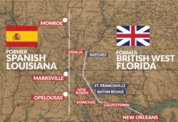
Map and information courtesy of Richard Campanella, designed by Erin Theriot
An 1864 map with contemporary city names added, indicating how the featured settlements formed bulwarks/”barreras” between the Spanish and British empires in the late 1700s.
It’s not boudin, roux, or zydeco, nor is it anything Cajun or Creole. Rather, the answer comes into relief with a simple mapping exercise.
Draw a line connecting Monroe in Ouachita Parish with Marksville in Avoyelles and Opelousas in St. Landry. Separately, connect Vidalia in Concordia Parish with New Roads in Pointe Coupée.
What you’ll see is two parallel north–south lines, one tracing the topographic crest west of the lower Mississippi Valley and the other running along the west bank of the river itself. A third line may be added to connect the now-gone settlements of Bayou Manchac and Galveztown with New Orleans.
Now go back two and a half centuries and picture two rivalrous empires eyeing each other across those lines. To the west were the Spanish, whose colonies extended through present-day Texas and Mexico down to Argentina; to the east were the British, ranging from Baton Rouge up to eastern Canada.
Opelousas, Marksville, Monroe, New Roads, and Vidalia. . . . all reinvented themselves as crossroads, river landings, trade centers, and/or parish seats.
Monroe, Marksville, Opelousas, Vidalia, and New Roads all trace their origins to Spanish military outposts positioned strategically to defend against British attack. It was a settlement impetus that lasted for only two decades, but in the annals of human geography, that’s all it takes for a community to germinate.
Let’s back up a bit. Prehistorically, Indigenous nations occupied this entire region, on lands varying from alluvial bottomlands to piney terraces and grassy prairies. By the mid-1600s, their numbers had been greatly reduced by European diseases, namely smallpox, first introduced in the 1540s. By the mid-1700s, France claimed this region, even as it battled British troops over conflicting claims to the north and east.
Foreseeing defeat in what we now call the French and Indian War, King Louis XV in 1762 secretly offered Louisiana west of the Mississippi (plus New Orleans) to his Spanish cousin, King Carlos III. Such a move would keep the vast territory in the Bourbon family, prevent it from falling under the Union Jack, and reward Spain for its support in what Europeans would call the Seven Years’ War.
Having his hands full with an unwieldly global empire, Carlos initially balked at the offer. But he soon accepted Louisiana on the notion that it would serve as a barrera (barrier, or bulwark) protecting Spain’s true prize, the Spanish Main to the west, from an enemy that would now advance into British West Florida, just across the Mississippi.
Between 1763 and 1769, Spain incrementally gained control of Luisiana and launched a policy described by historian Gilbert Din as poblando la barrera—“peopling the barrier.” It entailed recruiting Spanish subjects from Málaga, Granada, and the Canary Islands to immigrate, while offering land grants to other (preferably Catholic) migrants and refugees, including the Acadians. Spain also reopened the transatlantic slave trade.
At the same time, Spanish leaders in New Orleans perused maps for opportunities to guardar (guard) la barrera, up on topographic crests as well as down on key riverbanks. One possible military position lay in the Attakapas region to the west. In 1765, Spanish soldiers explored the prairie terrace rising beyond the Atchafalaya Basin and found a salient hillock once occupied by the Opelousa and later by French colonizers. Offering a perch over the lowlands to the east, the site became a Spanish military garrison named Los Opeluzás and a node for adjacent settlement via a number of intersecting roads. Officials granted nearby parcels to Acadian and Spanish settlers, which brought about the construction of houses, stores, and a Catholic church, as well as the establishment of farms and enslaved plantations. With this sort of “peopling,” Spanish officials sought to defend against the British threat—all the better if it yielded economic benefits for the Crown.
That threat diminished after American patriots rebelled in the Thirteen Colonies, drawing British military attention away from the southwestern frontier. Following the Americans’ victory in 1783 and their gifting of British West Florida to the Spanish, Los Opeluzás had lost its original siting rationale, but garnered enough momentum to grow on economic grounds. “Later when the fort was dismantled,” writes William J. Sandoz in a 1925 article for The Louisiana Historical Quarterly, “many of the soldiers preferred remaining and took up their permanent residence here, so that the nucleus of what is now the City of Opelousas was formed.”
Forty miles north of Opelousas rises what geographer Milton Newton describes, in Louisiana: A Geographical Portrait (1987), as “an island-like plug of terrace-like land” forty feet above surrounding lowlands. Known as the Avoyelles Prairie, this upland attracted Indigenous settlement as far back as two thousand years ago, leaving behind what archaeologist Chip McGimsey describes in a 2003 article for Southeastern Archaeology as “the largest and most complex Middle Woodland site in the lower Mississippi Valley.” French colonials arrived around 1700 and scribed the name of its people as Avoyel, meaning “flint people.” By 1780, trading activity with the Avoyel and Tunica tribes became sufficiently valuable for Spanish authorities to dispatch four Frenchmen in service of Spain—Noel Soileau (Soilleaux), Jacques Gagnard, Domingo de Apereto, and Estevan de la Morandier—to establish the Poste des Avoyelles upon the ancient earthworks, giving it a similar topographic perch as at Opelousas.
The garrison was later moved to a site closer to a road intersection, which is where, in 1796, Lieutenant Governor Don Carlos de Grandpre secured a land grant. Around that time, a Venetian-born peddler of Jewish descent named Marcos Litche (Marc Eliché or Mark Elishe) happened along one of those roads when, the story goes, his wagon broke a wheel. The delay gave Litche time to assess the Avoyelles Prairie, and finding it to his liking, he obtained a land grant next to that of Grandpre. He soon married a Creole woman, built a home, and opened a trading post at what came to be known as Marc’s Ville, Marc’s Store, Marc’s Village—and eventually Marksville.
While Spanish troops manned their garrisons at Opelousas and Avoyelles, Governor ad interim Esteban Miró commissioned Juan (Jean Baptiste) Filhiol to establish another defensive post a hundred miles north of Marksville. In 1782, Filhiol ventured up the Ouachita River as far as present-day Camden, Arkansas, before returning down to a confluence with Bayou deSiard called Prairie des Canots (Prairie of the Canoes), where French coureurs des bois traded among the Caddo, Osage, Tunica, and Choctaw. On an east-bank bluff downstream from the confluence, Filhiol established the Poste de Ouachita and in 1790 began building Fuerte Miró.
By this time, defeated British colonials had departed the region and American officials moved into what is now the State of Mississippi. While the United States and Spain maintained cordial relations in the aftermath of the Revolution, Spanish officials in Louisiana grew suspicious of the incoming Americans, who themselves were mostly English-speaking Protestants of British extraction with their own westward inclinations.
The Spanish continued to man Fuerte Miró even as it became clear it would serve more as a magnet for settlement than a bastion against invasion. “The fort accomplished what Filhiol could not do himself,” writes historian Gordon E. Harvey in Historic Ouachita Parish: An Illustrated History (2007), in that it “create[d] a center of activity, commercial and otherwise, for the area. . . . Court, commerce, and communication were all hosted at the fort, forcing the local residents to gather there and creating a sense of community.” As at Opelousas and Marksville, Spanish land grants brought settlers to the area, and Fuerte Miró became the nerve center of the Ouachita District.
After Louisiana returned to French dominion in 1800 and transferred to the United States in 1803, the former Spanish fort became an American garrison, and two years later, surveyors laid out an adjacent street grid. The community of Fort Miró became the seat of Ouachita Parish in 1807, and in 1819, the steamboat Monroe navigated up the Ouachita to the Bayou deSiard confluence, inspiring residents to rechristen their community as Monroe, Louisiana.
Now let’s consider British West Florida’s two main western population centers. One was the area from Baton Rouge up to St. Francisville; the other was Natchez in present-day Mississippi, situated high on a loess bluff overlooking Luisiana.
How best for the Spanish to guard against these British footholds? In the case of Baton Rouge and St. Francisville, it was to fortify the extant French settlement at Pointe Coupée (“cut point”), where Fausse Rivière (False River) had broken off from the Mississippi in 1722, and where French authorities had established Le Poste de la Pointe Coupée. After the 1760s regime change, the Spanish sent their own troops to the poste at what they called Punta Cortada, and began poblando (peopling) the area through land grants for enslaved agriculture. By the late 1770s, workers blazed a road southward from the riverside Spanish garrison to the plantations along False River, which Francophones had named the chemin neuf (new road) and Hispanophones called camino nuevo, to distinguish it from the older Royal Road, or Camino Real. Years later, when Anglophones came into the region, Camino Nuevo became New Roads, Louisiana.
Similarly, the best way for the Spanish to guard against Anglo interests at Natchez, be they British or American, was to establish a militarized presence directly across the Mississippi. In 1798, Don José Vidal, a Spanish navy captain who fought the British during the Revolution, founded Fuerte Concordia on a strategically positioned promontory (point bar). After subsequent changes of dominion, Vidal donated land for the fort-side settlement of New Concordia to host the new Concordia Parish courthouse. In 1811 Vidal won a seat in the State Legislature, and it was that body that renamed New Concordia in honor of José Vidal, giving us today’s Vidalia, Louisiana.
Not all late-colonial garrison towns endured into the American era; those at Bayou Manchac and Galveztown, for example, failed to regain momentum and have since disappeared. Opelousas, Marksville, Monroe, New Roads, and Vidalia, on the other hand, all reinvented themselves as crossroads, river landings, trade centers, and/or parish seats. Born as by-products of imperial intrigue, these five incorporated cities are now home to 75,000 Louisianans.
Richard Campanella, a geographer with the Tulane School of Architecture and Built Environment, is the author of Crossroads, Cutoffs, and Confluences: Origins of Louisiana Cities, Towns, and Villages, Draining New Orleans, Bienville’s Dilemma, and other books. He may be reached through richcampanella.com, [email protected], or @nolacampanella on X.