An Ominous Effervescence
The Bayou Corne sinkhole
Published: February 29, 2024
Last Updated: June 1, 2024
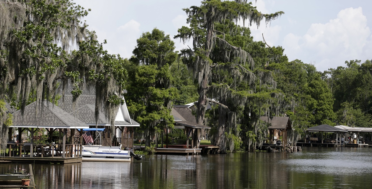
Photo by Gerald Herbert, AP Photos
A 2013 photo shows evacuated houses along Bayou Corne.
In mid-2012 local anglers began to notice an effervescence in Bayou Corne. At first residents wondered if the bubbles, which collected in clusters on top of the water, were symptoms of a leaky gas pipeline at the bottom of the bayou. Concerned calls were made to the local gas company, and they sent out an inspector, who found everything in working order.
Then the earth started to shake.
“Since earthquakes had never before occurred in this part of Louisiana, one woman imagined a ‘garbage truck had dropped a dumpster,’” Arlie Russell Hochschild wrote in her 2016 book, Strangers in Their Own Land. One resident, Mike Schaff, later found a crack across his living room floor.
The neighborhood periodically filled with foul chemical and gas odors, and the ground continued to shake. Earthquake monitors were installed in the area, which initially registered up to twelve daily tremors. The tremors and odors continued and ramped up in frequency into late July.
Less than a mile southeast stood Texas Brine: a mining operation that had extracted brine from a well thousands of feet deep from 1982 to 2011. Brine has several industrial applications and plays a part in chlorine manufacturing and fracking operations—both local enterprises in South Louisiana. The well had been bored into a leased “cavern” of the Napoleonville salt dome—a massive underground deposit of salt formed from the evaporation of ancient oceans. Locals and officials questioned Texas Brine about the tremors and bubbling, and toward the end of July, in response to all the seismic activity in the area, the company officially denied the likelihood of one particular outcome: a sinkhole.
If you were to put a boat in at Bayou Corne and Louisiana Highway 70 and paddle three quarters of a mile south, you would almost see the Texas Brine complex straight ahead of you. At that point, you’d also be within eyeshot of the massive Bayou Corne sinkhole to your left, through an ever-thinning cypress grove.
When the Earth Opened Up
In the early-morning hours of August 3, 2012, two acres between Bayou Corne and Texas Brine disappeared into a watery hole hundreds of feet deep. Nearby residents woke up to the gasoline smell of sweet crude oil wafting through the streets.The earth was unstable. The gas that had previously effervesced the bayou now appeared ashore, bubbling up from puddles and through people’s lawns. Governor Bobby Jindal ordered an evacuation on the same day, which affected about 350 people residing along Highway 70 between Bayou Corne and Highway 69.
Texas Brine drilled a relief well to investigate soon after the sinkhole opened up. A few months later, it was determined that the northwestern outer wall of the Napoleonville salt dome had collapsed. Salt dome caverns typically fail from the top, so the tops of caverns are coated in diesel to prevent erosion and collapse. The walls of the cavern don’t commonly collapse. Never before had earthquakes heralded the formation of a sinkhole, either. There was no precedent for how to handle the situation at Bayou Corne, nor what to expect.
The Napoleonville salt dome is the largest in Louisiana and contains more than fifty “caverns” operated by different companies—including Texas Brine and the collapsed cavern, called Oxy 3. These caverns are created by brine mining operations that inject water into the salt dome in a specified area, which dissolves the salt, making it transportable as brine. When the brine solution is removed, the resulting hollows are often leased as storage space and used to store various materials, such as natural gas, butane, and petroleum. These caverns are encased in a solid layer of rock salt within the larger salt dome. On the outside edges of salt domes, pockets of crude oil and gas are common and naturally occurring.
In Texas Brine’s official survey of the Oxy 3 cavern, done when the well was first drilled in 1982, the Oxy 3 cavern’s proximity to the outer wall of the Napoleonville salt dome was not accurate. In reality, the well was less than one hundred feet from the outer wall of the dome, as another survey showed a few years before the sinkhole opened up. At the time, Louisiana regulations did not prohibit drilling so close to the wall, though many other states do. (Louisiana adopted stricter salt dome drilling regulations in the years following the sinkhole event at Bayou Corne.)
When Texas Brine applied for a permit to expand the cavern in 2010, the cavern could not hold pressure, failing the state-mandated integrity test. A Texas Brine executive said that a breach appeared possible in the Oxy 3 cavern, so instead of expanding the cavern as planned, the decision was made to plug and abandon the well in 2011.
For three years, the sinkhole grew, taking down hundred-foot-tall trees and acres of swamp as it went. Burnoff stations were installed in the ground to burn as much of the escaping hydrocarbons as possible. Despite the evacuation order, most residents were slow to leave—either because they weren’t ready to give up on their slice of paradise, or they didn’t believe the area was unsafe.
The earth was unstable. The gas that had previously effervesced the bayou now appeared ashore, bubbling up from puddles and through people’s lawns.
Those who stayed got to know some new faces, such as a cohort from the Louisiana Department of Environmental Quality, as well as environmental scientist Wilma Subra, technical advisor to the Louisiana Environmental Action Network. Subra, a 1999 MacArthur “genius grant” Fellow and Morgan City native, taught the remaining residents how to keep records of odors and their health symptoms with their phones. Combining that data with information from the earthquake monitors, Subra was able to establish a link: people reported getting headaches and other physical symptoms, coinciding with reports of chemical odors, every time an earthquake happened.
“What they were having as negative health impacts, it always related back to the time that they were having earthquakes,” Subra explained. “And when there was an earthquake, it released a lot of methane from the caverns, and a lot of brine with crude oil.”
Within a year, the sinkhole had grown to twenty-five acres. Natural gas in high levels is toxic to humans, and high concentrations were found in several homes. Natural gas and methane are, of course, explosive. Hochschild wrote that resident Mike Schaff installed a gas monitor in his garage so that he’d be alerted if methane and natural gas concentrations got too high. His wife moved to Alexandria, and Schaff would visit her on weekends, but he stayed behind at Bayou Corne to keep an eye on his property, along with his neighbors’ properties. The uncertainty of the situation kept Schaff on his toes, and he warned family and friends to stay away because he could not guarantee their safety.
“With the methane gas emissions all around us, it’s not safe,” Schaff explained in Hochschild’s book. “The grandkids don’t come either, because what if someone lit a match?”
Fault, Litigation, Compensation
Texas Brine deflected blame for the sinkhole in all directions. Initially, the company claimed the earthquakes and the sinkhole were natural phenomena, and that earthquakes occurred naturally in the area. When that approach didn’t work, the company sued Occidental Chemical Company, which leased the cavern to Texas Brine. Meanwhile, Texas Brine filed a claim to their insurer, who determined Texas Brine to be at fault and therefore refused to pay out any loss claims for the policy. Texas Brine then sued the insurance company. The state of Louisiana also filed a lawsuit against Texas Brine and Occidental for damages, and in 2018, a judge found three guilty parties: Texas Brine, Vulcan Materials (which rented mineral rights to the Oxy 3 site until 2005), and Occidental Chemical, with the latter ruled to have the biggest share of responsibility. Texas Brine also sued Occidental Chemical’s parent company, Occidental Petroleum, for hundreds of millions of dollars in damages.Past the Corner of Gumbo and Jambalaya
Today, the sinkhole spans nearly thirty-seven acres and appears as a lake, bordered by Bayou Corne on its southwest side, with a margin of land between them. The subterranean guts of the sinkhole appear to be at peace after years of shifting and settling. An earthen berm has protected the bayou itself, thus far.From the start of the evacuation, Texas Brine paid residents $875 per week as compensation. Nine months after the sinkhole appeared, Governor Jindal threatened to shut down the company if they didn’t offer to buy out homes, so they obliged. Eventually, many residents took them up on the offer. Texas Brine now owns much of the former retirement and fishing camp enclave. A small cabin rental business still operates on the bayou, and posts to Facebook when the fish are biting, but there aren’t many people left on this stretch of Bayou Corne. Mike Schaff also moved out of his home.
“Still today, after a rain, you can walk out there and see [methane] bubbling out of the ground,” Subra said.
Outside of concrete foundations, not much remains as you turn onto Gumbo Street from Highway 70. At the intersection of Gumbo and Jambalaya Street, two signs placed on either side of the road tell the public to keep out, and that security cameras are in use. Beyond the signs, the land appears reclaimed by nature.
But on Google Street View, as of this writing, Gumbo Street past these signs is frozen in time, as Google has not updated the footage since 2008. Once you glide past the present-day “Keep Out” signs, you can see what the community looked like in 2008: humble and well-kept yards, proud homes, cars and boats in driveways. The residences and camps on Sauce Piquante Lane and Crawfish Stew Street are remarkably close to each other. It’s easy to see how these neighbors would become a tight-knit community, and why so many of them lingered as long as they could, even after their homes became part of an industrial disaster.
By February 2014, about 80 percent of the residents affected by the sinkhole had moved out of their homes. Texas Brine pushed to wrap up its property buyouts in the area in early 2015, around the time the sinkhole began to stabilize. When the mandatory evacuation—which some residents had not heeded—was lifted in October 2016, there were only about a dozen families left in the area. The 2020 US Census recorded a population of 32 in the Bayou Corne area, down from about 350 before the sinkhole opened up.
Subra understood why some could not bring themselves to leave while the disaster unfolded. “[Texas Brine] didn’t give enough for them to relocate out of the area,” said Subra. “I mean, you can’t relocate out of the area. There’s no other place in the world like that place.”
Christie Matherne Hall writes about foodways, culture, travel, and natural disasters for 64 Parishes and Country Roads. She is also a podcast producer for the Western Colorado Writers’ Forum and an editor for wallethub.com, and enjoys helping people write their memoirs through the Story Terrace platform.
