Geographer's Space
Arpents, Ligas, and Acres
The cadastral system left cultural fingerprints on Louisiana's landscape
Published: March 1, 2016
Last Updated: October 30, 2018
In the years following the Louisiana Purchase, nobody needed to evidence that argument; distinctions were pervasive and profound. Creoles and Americans did just about everything differently, from language and religion to law, architecture, servitude, urban design, and even cemeteries.
Another difference that affects the Louisiana landscape to this day involves the seemingly arcane concept of a cadastral system.
The term comes from the Latin capitastrum, meaning a register or ledger. A cadastral system is a method of surveying land into parcels (cadasters) and recording their locations, dimensions, and ownership in an official record.
They sound quotidian, but cadastral systems are important in ways that cannot be overstated. In a free-market economy such as ours, in which agency is availed to the individual, privately owned land is the provenance of wealth, undergirding all subsequent financial commitments and constituting the original valuation to which all future value is added. (Marxism, on the other hand, views labor as the source of wealth and, bent on holding land collectively, looks askance at cadastral systems.)
Cadastral systems, and the gravitas with which they are maintained, thus become critical to the chain of financial agreements and investments that follow. In a system where wealth begets wealth, the begetting begins with land—and all subsequent begetting needs to see the capitastrum confirming the particulars.
When Western powers claimed the Americas, they understood that land conceded to private entities would quite literally lay the groundwork for wealth production. They proceeded to survey cadasters over lands previously occupied by indigenous societies with no such concept. What followed ranks as the largest land transfer the world has ever known, and it would create tragic injustices for some while imparting key advantages to others.
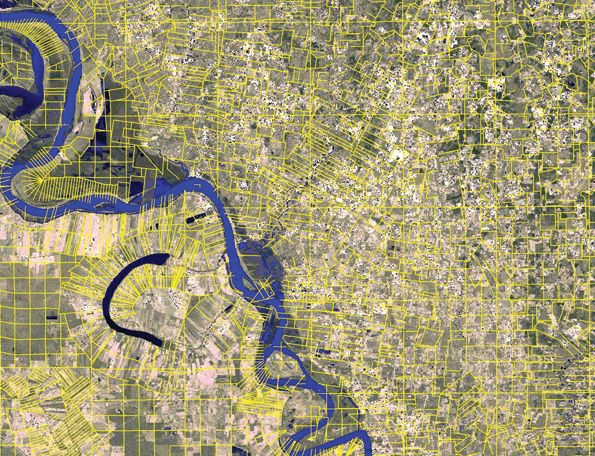
Survey lines showing French long lots and American township-and-range at lower left, and English metes-and-bounds at upper right. Courtesy of Richard Campanella
The Four Systems
Just as English, French, Spanish, and American societies practiced different philosophies of law and government, each also “did” cadastral systems their own way. English settlers brought over their metes-and-bounds method, which documented parcels by the streams, ridges, boulders, trees, or roads which met (“mete”) to form the property’s boundaries (“bounds”). Metes-and-bounds worked fine until, rather inexorably, streams migrated, boulders rolled, and trees died. The result: feuds, lawsuits, and an obstacle in the land-ownership/wealth-creation cycle.
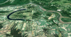
The French, who mostly colonized riverine environments, subdivided land into “long lots” with narrow frontages along the waterway and an elongated slice of the fertile land behind it. This arrangement aided transportation and irrigation as well as animal-drawn field work, minimizing the number of turns.
Spanish authorities, with their focus on ranching over cropping, had little need for elongated riparian lots or irregular family farms, so they created expansive sitios or ranchos (estates) instead.
The Americans, namely Thomas Jefferson, developed something entirely different, and it would be revolutionary. Known today as the Public Land Survey (PLS) or “township-and-range,” their system was based not on curvaceous or ephemeral landscape features but on a theoretical grid of cells with unique labels set within a baseline and principal meridian (X and Y axis). Township-and-range’s spatial rigidity, in addition to its tedency to precede rather than follow initial settlement, turned land into a rock-solid foundation for wealth production—at least for those who could lay their hands on it.
Cadastral Fingerprints on the Louisiana Landscape
It took a while for the French to establish a stable cadastral system in Louisiana, given the colony’s weak and distant authority. Instead, vast concessions were made liberally, and too often they were used merely for timber extraction rather than agricultural development.
Displeased, the Crown issued an edict in 1716 which provided for land redistribution “in the proportion of two to four arpents front by 40 to 60 in depth.” An arpent was the equivalent of an English acre, measuring 192 feet, and the surveyor who laid them out was the arpenteur.
Viewed cartographically, the French long-lot (or arpent) system traced a splendid serpentine effect, with parcels converging in concave river bends and diverging on convex sides. Viewed economically, the system made hydrological and geophysical sense and benefited from careful administration. By the 1750s, riparian lands throughout lower Louisiana had the French cadastral imprint.
But by this time, war raged between England and France. Sensing impending defeat, the French ceded all its territories west of the Mississippi plus New Orleans to the Spanish, to keep them out of the hands of the hated English—who got everything else.
Louisiana is distinct among the 50 states because it retains the cadastral imprints of all four powers of the North American stage.
Now Spain and England would inscribe their cadasters into the Louisiana landscape.
Spanish authorities, not wanting to rile disgruntled French Creoles and realizing this environment was better suited for agriculture than livestock, respected extant cadasters and allowed French long lots to continue. However, in the Mexican territory near the prairies of southwestern Louisiana, livestock took priority, and Spanish officials laid out cattle-friendly sitios measured by units such as varas (rods) and ligas (leagues). To this day, southwestern Louisiana is cowboy country, and it exudes a Texan air.
As for the English, their slice of Louisiana was called British West Florida, and to its lands Anglo settlers brought the same metes-and-bounds system of the Eastern Seaboard. With Britain’s defeat in the American Revolution, this area became Spanish West Florida—but once again, the Spanish decided to recognize extant English cadasters.
The new century brought stunning new developments for Louisiana. The English by this time were long gone, though their metes-and-bounds remained in the Feliciana parishes. The Spanish retroceded their part of Louisiana to the French in 1800, but left behind their sitios in the southwest. The French then sold the colony to the United States, but left their arpents along Louisiana’s rivers and bayous.
That left millions of other arpents—or rather, acres—for the Americans’ township-and-range. They began in 1807, when surveyors extended the 31st parallel westward (the northern boundary of old Spanish and British West Florida and the “top” of the Florida panhandle today) to form the baseline. For the principle meridian, 92o 24’ 55” West longitude was selected because it ran through the middle of the Territory of Orleans. Thus forming the X-Y axis for the townships, ranges, and sections needed to parcel out Louisiana lands west of the Mississippi River. For lands to the east, the circa-1803 Washington Meridian was extended southward (in 1819) along longitude 91o 09’ 36” to form a secondary Y-axis, called the St. Helena Meridian. The stage was now set to superimpose American order over colonial chaos.
Alas, the Creoles would hear none of it, and the Americans, like the Spanish, wisely did not press the issue. Why make unnecessary trouble? Cadastral systems, after all, have deep cultural resonance, and because of their foundational capacity to generate wealth, it takes little short of a radical revolution to eradicate them.
So instead, Congress passed an act in 1807 confirming most colonial-era land holdings, and a second act in 1811 authorizing surveyors to continue laying out long lots in areas of colonial settlement. Township-and-range would fill in everywhere else.
What resulted was a cadastral map that looks a bit like water spilled on graph paper, with the old French system splaying out along finger-like rivers and bayous and the rigid American grid filling in between. And if you peer closer, you can still see old English metes-and-bounds in West Feliciana Parish and relics of old Spanish sitios by Texas.
Louisiana is distinct among the 50 states because it retains the cadastral imprints of all four powers of the North American stage: French (including French Canadian), Spanish, English, and American. Just as we have a uniquely mixed legal jurisdiction of Roman civil law and English common law, we also have a one-of-a-kind cadastral amalgamation, and it influences literally every space we traverse daily.
So next time you debate Louisiana’s distinctiveness, set aside the standard food-and-music arguments and explain instead the state’s cadastral story. Better yet, invite people to get a window seat on their next flight and gaze at the landscape below. They’ll see patterns in Louisiana unlike any other in the United States.
—–
Richard Campanella, a geographer with the Tulane School of Architecture, is the author of “Bourbon Street: A History,” “Bienville’s Dilemma,” “Geographies of New Orleans,” and other books. He may be reached through richcampanella.com, [email protected], or @nolacampanella.