Winter 2007
End of the Line
Plaquemines Parish architecture
Published: October 3, 2022
Last Updated: October 3, 2022
U.S. Army Corps of Engineers Digital Visual Library
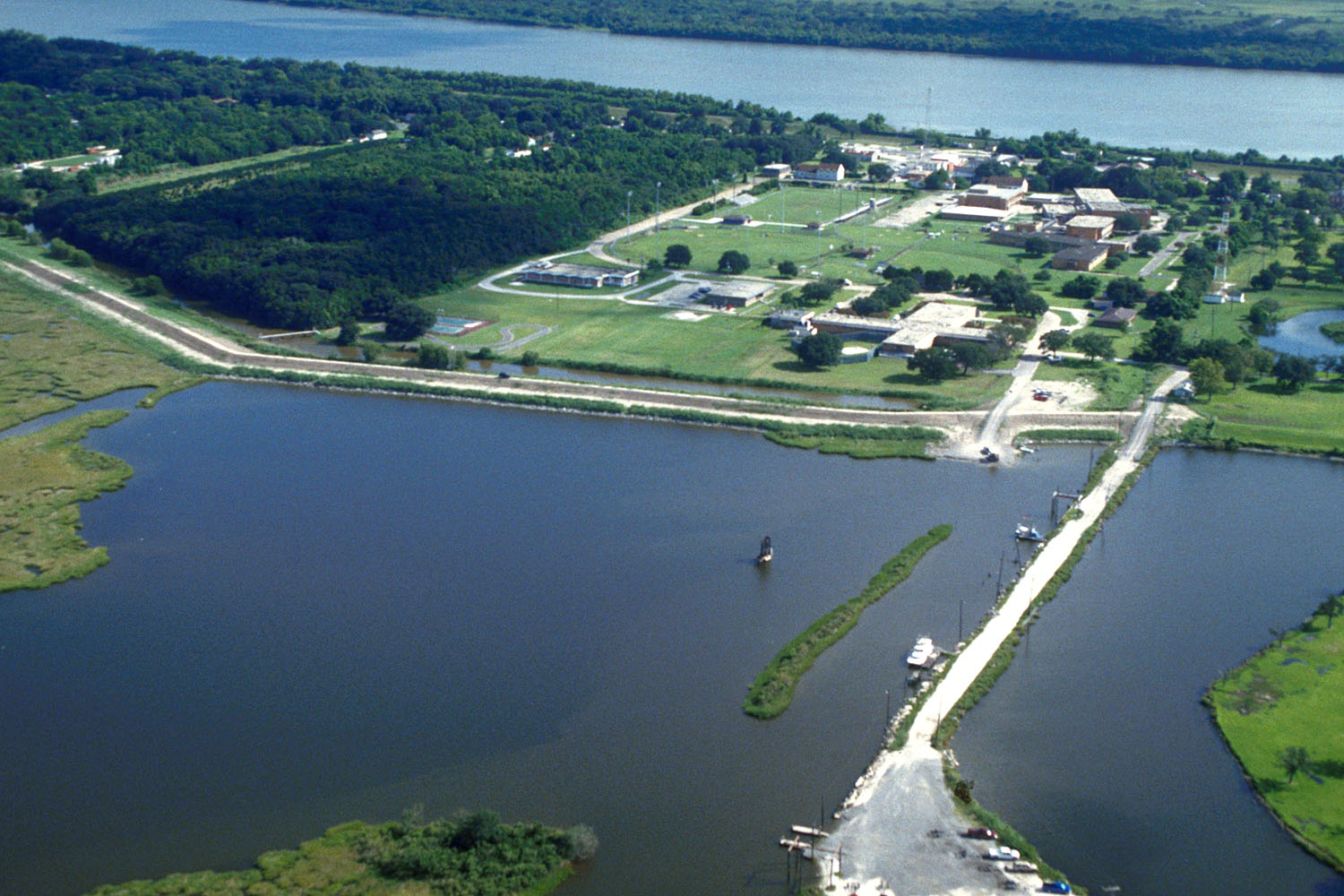
Aerial view of Port Sulphur in 1999.
Although its landscape is quite the opposite of these mountainous vistas, Plaquemines Parish can evoke similar emotions. As one gets closer to the mouth of the Mississippi River where the distinction between land and water disintegrates, the sheer physical presence of the landscape is astonishing. It is so flat, so wet, and so fragile that it achieves qualities of the sublime. To build on this is a challenge and what has been built has come and gone with greater rapidity than in many places.
Hurricane Katrina covered Plaquemines with more than 20 feet of water, but many individual buildings and communities had disappeared long before Katrina. The Balize, a small fort built in the 1720s on a little island at the mouth of the Mississippi, is long submerged. Manila Village, a Filipino fishing settlement that became a hub of the shrimp drying industry in the 1890s, was destroyed by Hurricane Betsy in 1965.
As a gateway to New Orleans and control of the lower Mississippi River, Plaquemines was shaped architecturally by its strategic location. Fort Jackson, named in honor of Andrew Jackson, was built to safeguard the river approaches to New Orleans from the Gulf of Mexico. It went up on the site of an earlier ca. 1792 Spanish redoubt that was destroyed by a hurricane in 1795. The star-shaped fort has brick walls that are 20 feet thick and rise 25 feet above a surrounding moat. It looks impenetrably solid and strong, and is the only one of several forts in the parish that has survived. Nevertheless, Fort Jackson was bombarded in 1862 and failed to prevent the Union fleet under the command of Admiral David Farragut from proceeding upriver to New Orleans in April 1862. Fort Jackson functioned more successfully for another war. Several units were housed there during their training for World War I. Then in 1926, the fort was declared surplus property and, later, designated a national historic monument and opened to the public in 1962.
Plaquemines Parish was formed from alluvial and delta plain deposits when the Mississippi River changed its original exit into the Gulf and chose this route as recently as a few hundred years ago. The parish borders both sides of the river for approximately 70 miles, and the river has always been central to Plaquemines’s culture and architecture. After engineer James B. Eads constructed jetties at the river’s South Pass in 1879 to force the river to scour a deep-water channel as a route for ocean-going ships, the land that flanked it inevitably developed to service his industry.
The parish’s linear shape also has determined the nature of its built landscape. A journey from
New Orleans towards the river’s mouth on the west bank includes Belle Chasse, home of the Naval Air Station, oil wells, chemical plants, new subdivisions at Jesuit Bend, orange groves, the Bayhi cemetery, herds of cows, marine terminals, and grain elevators. There is no simple progression of buildings from agriculture to industry or the reverse. Rather, they jostle each other for position. What is reinforced is the linear nature of it all. Trees, telephone and electricity poles, and houses set up a rhythm against the contour of the levee and beyond it, the river. Boats and ships, of which only the tops are visible, punctuate the levee’s silhouette; hurricane damaged broken trees make the ships more visible now.
Plaquemines Parish derives its name from “piakimin,” the Muskogean or Mobilian word for persimmon, which once grew abundantly here. The parish’s rich and fertile soil made it important agriculturally, with sugar and rice the principal crops in the nineteenth century and, more recently, the citrus industry — oranges and satsumas. In 1860, there were said to be thirty-one large slaveholdings in Plaquemines. The buildings that composed these are almost entirely gone.
Woodland survives. The former plantation house, built perhaps in the 1830s or in the 1850s, operated as a sugar and a rice plantation in the following decades. In 1850 Woodland was home to 181 enslaved people who worked the property. Now, the house is a bed-and-breakfast inn. The wide one-and-one-half-story wooden house is raised on brick piers and has galleries at both the front and the rear, as well as five dormer windows front and rear. When built, the house was oriented to the river, which was then the principal transportation route, and so that side of the house is its proper front. But the duplication of galleries front and rear gives the house a formal appearance when approached from the rear, road side. Despite the Greek Revival influences in the building’s door and window surrounds, the house does not have the central entrance and hall typical of that style. Instead, it follows older patterns with an off-centered entrance. In 1998, St. Patrick’s Catholic Church, a wooden Gothic Revival structure built in 1918, was moved from Port Sulphur to Woodland and renovated as a restaurant. Both buildings stand out, are monumentalized, on the surrounding flat terrain.
Industry came to the parish in the twentieth century. Most interesting was the creation of Port Sulphur in 1933, a townsite and the processing and shipping point for the Freeport Sulphur Company’s sulphur mine at Lake Grand Ecaille. Sulphur, also known as brimstone, is used for all kinds of consumer products and is an important component of agricultural fertilizers. The sulphur was brought to the company’s dock west of the town. Production facilities for the sulphur and the first group of employee houses were completed rapidly, within the space of twelve months. Approximately 200 houses were ultimately built in a grid plan on filled-in land to raise the town above the storm tide. Churches, a hospital, boarding house, and school were included. At its peak, more than 800 people lived there.
In the 1950s, Freeport built an administration building with a four-columned portico in a Colonial Revival style. After the company ceased operations at Grand Ecaille in 1978, the building was acquired by the parish and, in 1984, adapted for use by Plaquemines Parish government. The building’s sturdy red brick walls and pedimented portico give the building an air of importance and weightiness it would not have if built of wood. The town of Port Sulphur survived the closing of the mine, but the town, nestled amid trees, was badly hit by Katrina; trailers long stood in for many of the homes. And the town’s relationship to the river is made more evident by the enormous metal wall heightening and reinforcing the levee.
Further downriver, the town of Buras, founded by seven brothers from France of the same name, reflects its riverside location. It is a linear town laid out with its three principal streets parallel to the river. It too suffered terribly from Katrina, but the brick school and its huge auditorium anchored the town’s core and its rebuilding.
Proceeding toward the Gulf, pausing momentarily for the passage of historic time at Fort Jackson, the last stop is Venice. Untidily holding onto land, its architecture is support buildings for docks and fishing boats and the helicopters for oil rigs in the Gulf. Around, water threads through everything, and Plaquemines’s marshes dissolve into a sublime and sweeping landscape of water and sky.
Karen Kingsley, PhD, is professor emerita of architecture at Tulane University, author of Buildings of Louisiana (2003, Oxford University Press), and a free-lance writer.
