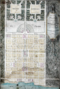
Plano de la villa de Baton Rouge
The plan shows the layout of the area of the city know as Beauregard Town. This is a certified copy made in 1809 of the original plan drawn in 1806.

Courtesy of Louisiana State University Libraries, Special Collections
Plano de la villa de Baton Rouge. Latour, Arsène Lacarrière (cartagrapher)
Additional Data
| Courtesy of | Louisiana State University Libraries, Special Collections |
| Date | 1809 |
| Copyright | Copyrighted |
| Disclaimer |
Physical rights are retained by the LSU Libraries. The Louisiana Endowment has included this work in 64parishes.org for the purposes of criticism, comment, teaching, scholarship, educational research, all other nonprofit educational usages under Section 107 of the U.S. Copyright Act. |