Beauregard Town
Baton Rouges' Beauregard Town, planned in 1806 by Capt. Elias Beauregard, is now a predominantly residential district.
Courtesy of Louisiana State University Libraries, Special Collections
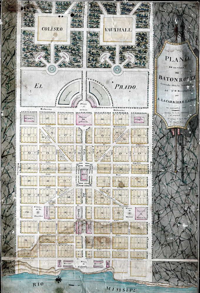
Plano de la villa de Baton Rouge. Latour, Arsène Lacarrière (cartagrapher)
The second-oldest neighborhood in Baton Rouge, Beauregard Town was designed during the period of Spanish rule in the city (1779–1810). With a unique street configuration, tree-lined boulevards at its borders, and open plazas throughout, it was envisioned as a new administrative center for the growing city as well as its elite new residential area. Measuring seven blocks north to south and nine blocks east to west, it contains the Old State Capitol, the Old Governor’s Mansion, and significant city and parish government buildings.
Today, Beauregard Town is predominantly a residential district. Its origins date back to 1806, when Capt. Elias Beauregard sought to realize an ambitious baroque-inspired plan for a new center for Baton Rouge, at that time the seat of government for the Spanish province of Florida (annexed by the United States in 1810). He hired French engineer Arsène Lacarrière Latour to draw up his proposal in the “Grand European Manner.” The general layout of Beauregard’s ambitious scheme can still be discerned today in this neighborhood’s street pattern.
The plan centered on a cathedral square, from which four diagonally radiating streets led to open spaces and public buildings, including a hospital and a college. In a bilingual (French and English) advertisement circulated in 1806 to announce the auction of residential lots, Beauregard described his plan: “The Public Buildings will stand at a distance from private property and are to be so situated in different parts of the town as to afford a more uniform value to all the Lots, and to contribute at the same time to general convenience and ornament.” A tree-lined boulevard named the Calle del Gobierno (now Government Street) bisected the area from west to east, crossing the cathedral square to the governor’s residence and, beyond that, to the troop barracks and then the formal gardens, which were to contain a coliseum and a vauxhall (pleasure garden). Markets, a customhouse, and the Plaza de Colomb were planned for the Mississippi River’s edge.
Many lots remained empty until the late nineteenth century, when a building boom swallowed the open spaces set aside for public plazas. Warehouses for the railroad and port sprang up in areas close to the river. The four radiating streets (Somerulos, Grandpré, Beauregard, and Penalvert) are still recognizable and retain their original names. In the 1960s Government Street was redeveloped as a major traffic route and essentially split Beauregard Town in two.
Three houses illustrate the variety of residential types in the district. Among the oldest is the one-and-a-half-story Gesell House (ca. 1866), galleried and five bays wide, located at 356 St. Charles Street, within the angle it forms with the diagonal Somerulos Street. The house is now occupied by lawyers’ offices. The former Fuqua House at 301 Napoleon Street, built in 1870, is five bays wide and one and a half stories tall, with prominent gables on three sides. J. K. Roumain, whose Roumain Building is a landmark in the city’s business district, built a two-story, galleried cypress house, perhaps designed by Baton Rouge architect Ben Goodman, at 201 St. Charles Street. A recent addition that echoes the pediments, gables, and columns of the neighborhood is an office building built in 1985 by Barron and Toups (320 Somerulos Street), a visually complicated structure with intersecting volumes, stairs, courtyards, and bays.
Adapted from Karen Kingsley’s Buildings of Louisiana, part of the Buildings of the United States series commissioned by the Society of Architectural Historians (www.sah.org) and published by Oxford University Press.
