Coastal Restoration
For a state experiencing land loss at an alarming rate, coastal restoration has become an urgent need.
National Oceanic and Atmospheric Administration
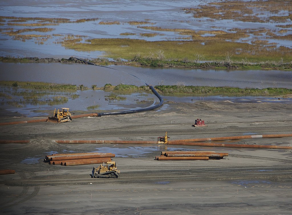
Coastal Wetlands Restoration After Hurricane Katrina, 2006
Louisiana’s Coastal Protection and Restoration Authority (CPRA) has declared coastal land loss a state crisis. Louisiana has lost more than eighteen hundred square miles of coastal wetlands since the 1930s. This loss results from multiple interacting processes including subsidence, erosion, faulting, mineral extraction, and sediment deprivation. The CPRA is actively pursuing an ambitious plan to restore portions of what has been lost and protect existing coastal wetlands.
Acknowledging Land Loss
Coastal land loss was commented on in the late nineteenth century, reported on in the scientific literature in the 1930s, and systematically measured for the first time in the 1950s. Recognition of the threat is nothing new, but deploying resources to restore the coast is more recent. In the last three decades, Louisiana and federal partners have endeavored to rebuild some of the coast’s wetlands and barrier islands. This effort reflects determination among many scientists and state officials that rebuilding some of the coastal wetlands can reduce some of the most severe impacts of land loss.
The Coalition to Restore Coastal Louisiana published the first substantive proposal for arresting coastal land loss in 1989. The organization included a mixture of environmental activists, academic researchers, civic and faith groups, and businesses. Its plan identified achievable projects that would draw on natural processes to redirect sediment to disappearing wetlands. At the plan’s core were three diversions designed to deliver sediment-laden river water into wetlands rather than emptying into the Gulf of Mexico through the leveed river channel. The idea was to mimic natural flooding and reroute a portion of the Mississippi River’s flow back into marshlands, where sediments would settle out and build land. The plan also called for utilizing dredged sediment from the river’s navigation channel to restore nearby wetlands.
The coalition proposed diversions through the Bonnet Carré Spillway into Lake Pontchartrain and the Mississippi Sound, at Caernarvon downstream from New Orleans into Breton Sound, and at Davis Pond into Barataria Bay. These diversions would add sediment to areas of rapid land loss and fortify the land buffer around New Orleans. No action was taken on the Bonnet Carré diversion; however the Caernarvon and Davis Pond projects had already been approved for federal funding, but not for the purpose of land building. They were intended to deliver freshwater to their respective destinations and modify salinity to benefit oyster and other marine fisheries. Nonetheless, they provided a basis to gauge the viability of diversions as tools for restoring the coast.
Federal Legislation and Early Planning Attempts
While the 1989 proposal did not come with state dollars for restoration, advocates convinced Louisiana’s congressional delegation to support federal legislation to secure funding for initial projects. The Breaux Act, legislation that informally bears the name of Louisiana Senator John Breaux, secured congressional approval in 1990. It provided a dedicated revenue stream that tapped a portion of taxes on fishing equipment and motorboat fuels. The act elevated the coastal crisis to a national priority and required Louisiana and federal partners to develop a comprehensive plan to arrest and reverse the loss of the Mississippi River’s delta wetlands. In 1993 a task force released the plan, which presented a coast-wide approach that stretched from Mississippi to Texas and did not focus solely on the bays surrounding New Orleans. It depicted several small diversions along the lower Mississippi River along with others into the Atchafalaya Bay, a set of barrier island restoration projects, shoreline protection efforts, and hydrologic restoration projects to offset saltwater intrusion.
A subsequent 1998 report, Coast 2050, peered fifty years into the future. Despite nearly a decade of funding and ongoing projects, the authors expressed frustration with what they considered inadequate progress. They touted a new approach that blended efforts from previous plans and integrated suggestions from citizens, academic scientists, and local, state, and federal authorities. Their approach broke the coast into several regions with specialized plans for each segment and individual timelines for their completion. A follow-up study in 2004 prioritized projects along with recommending demonstration projects. It also directed attention to particular types of basic research: studies of biophysical baseline conditions, engineering works, ecological processes, and social/political conditions. With each iteration of the restoration plan, specialists insisted on finer-grained approaches and ongoing progress monitoring. The primary focus was on restoring the ecology, geology, and hydrology of the coastal region.
Rethinking Restoration
In August 2005 Hurricanes Katrina and Rita wreaked havoc across coastal Louisiana and exposed the tragic consequences of storm-driven flooding. This dramatic revelation forced a re-emphasis on flood mitigation as a primary purpose of restoration and prompted a consolidation of state coastal specialists within one agency. This adjustment gave birth to the CPRA, which has primary responsibility for issuing a regularly updated Comprehensive Master Plan for a Sustainable Coast and the authority to carry out the projects. The CPRA issued detailed reports on planning and project completion in 2007, 2012, and 2017. The next is due out in 2023. As of 2017 the agency reported completing or funding 135 individual projects that benefitted 3,600 acres of land, improved 282 miles of levees, and aided some 60 miles of barrier islands or berms. Work on these and other projects continues.
The 2017 plan proposes $25 billion dollars in various restoration initiatives including marsh creation, sediment diversions, and other projects. The CPRA estimates that these projects can create or maintain some eight hundred square miles of coastal land. The plan also earmarks an additional $19 billion for structural protections like levees and associated infrastructure. A combination of restoration and protection efforts, the agency’s projects are estimated to reduce annual damages by $8.3 billion. Beyond direct damage mitigation, the planners tout benefits to the coastal ecosystem habitats that will benefit commercially valuable fisheries such as shrimp, crabs, oysters, and menhaden. Enhancing those marine species’ habitats will offer economic benefits to fishing families and related industries.
Facing Climate Change
In an era when sea level rise is accelerating and compounding the loss of coastal land due to subsidence and erosion, Louisiana’s efforts have been hailed as a forward-thinking approach to the threats of climate change. The state has arguably established itself as a leader in developing relevant science and engineering expertise and assembling the infrastructure to address its climate-related challenges. As a result, its specialists will be in high demand in other coastal locations.
Yet despite all the state’s efforts, coastal residents face huge challenges in the coming years. The state has lost more than eighteen hundred square miles since the 1930s, and its ambitious plan offers to restore or benefit only eight hundred square miles. There is no plan to fully restore the coast to its outline of 1930. In addition, the $50 billion price tag of recent plans will be difficult to sustain. Increasing costs will more than double the funds necessary to complete the plan in fifty years. The largest share of funds currently dedicated to the plan comes from penalties following the 2010 Deepwater Horizon oil spill, penalties that will be used up well before 2050. There will be repair bills when hurricanes damage completed restoration projects as has happened in recent years. As a result, finding adequate financing remains a massive concern.
The current plan focuses on building marshes and barriers islands through sediment diversion as well as providing protection for urban areas with levees and other structures. The CRPA is dedicated to restoring the biophysical environment and is not assigned the responsibility of restoring and protecting coastal cultures. However, the agency has expanded its efforts to engage with communities and to incorporate their concerns in the plan, though the state has not matched the focus on the biophysical environment with attention to coastal cultural restoration. Considerable attention has been directed towards studying ecological changes in the coastal region and how wildlife and marine communities might respond to restoration projects. To date, the state has not dedicated comparable research dollars to studying the impacts of coastal land loss on the social and cultural aspects of communities.
There is a small portion of the budget allocated to helping people on the coast elevate their houses so that they can remain in place. Yet little attention or funding is directed to assisting high-risk communities relocate to safety. Indeed the notion of retreat has not found favor among most coastal residents, but there is a place for this option in planning the coast’s future. The coastal community of Isle de Jean Charles sought a means to move to safety for decades. A federal grant to the Louisiana Office of Community Development has enabled residents to move to a newly built community near Houma. The project, while oriented towards community restoration, was not part of coastal restoration planning.