Coastal Land Loss
The gradual loss of Louisiana’s coastal wetlands is a slow-moving disaster largely set in motion by a series of human interventions in natural processes.
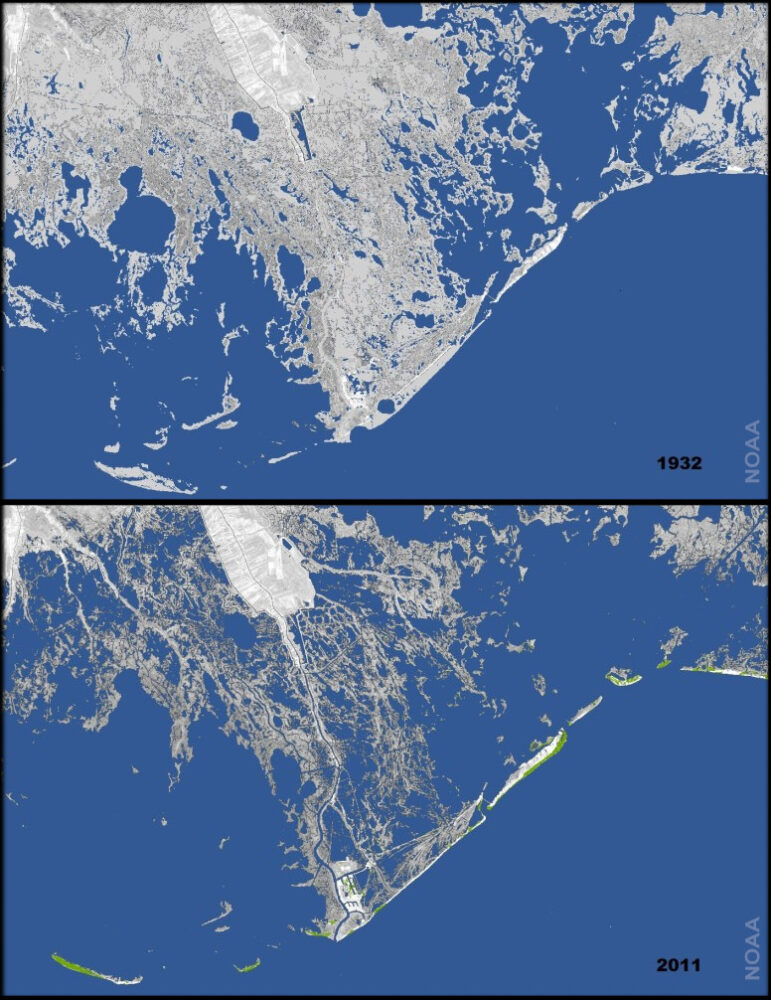
National Oceanic and Atmospheric Administration
Land loss in coastal Louisiana since 1932, ca. 2011.
Louisiana is susceptible to multiple types of disasters. Many result from natural hazards such as floods, hurricanes, and tornados. Some are rapid-onset events like hurricanes while others move much more slowly. A prominent slow-onset disaster in Louisiana is coastal land loss, which involves the disappearance of coastal wetlands due to a complex set of processes. The state has been monitoring this loss for decades and working to offset it for years.
A Land-Loss Crisis
So-called “natural disasters” that cause damage to human lives and infrastructure are due to the combination of natural forces and human decisions and actions, not just violent weather. In other words, they are not “natural” disasters. Geographer Gilbert White made the case in the 1940s that “floods are acts of god, flood losses are acts of man.” Louisiana’s coastal crisis is the result of interconnected human decisions about managing natural resources.
Louisiana refers to its chronic disaster as its “land-loss crisis.” Between 1932 and 2020, the state lost some eighteen hundred square miles of coastal land. The gradual loss of coastal wetlands, due to a variety of processes, is a slow-moving disaster largely set in motion by a series of human interventions in natural processes. River levees, built since the colonial era and reinforced during the twentieth century, prevent flooding and consequently eliminate the regular delivery of sediments to the river’s floodplain. The existing coastal land sinks under its own weight while the river, confined between levees, transports the sediment eroded from the agricultural lands of the Midwest and Great Plains out into the Gulf of Mexico. Exploration for oil and natural gas and their extraction in the coastal marshes involved the construction of some ten thousand miles of canals, which have contributed to saltwater intrusion and wetland erosion. The hydrologic modification, mineral removal, and natural faults have accelerated subsidence of wetlands. The degradation of oyster reefs and mangrove trees compound the problem by allowing waves and storm surge to erode coastal lands. The human introduction of destructive nutrias into wetlands in the 1930s has also contributed to the crisis. Finally, in Louisiana and globally fossil fuel consumption has accelerated climate change and rising sea levels. Thus, the state’s land-loss crisis is clearly not a simple consequence of natural processes.
Consequences
Early explorers largely avoided the state’s coastal wetlands, and colonial-era maps only depicted vague boundaries of the state’s shoreline. More detailed navigation maps in the early twentieth century offered a more accurate cartography of the coasts. With these improved maps, and aerial photographs since the 1930s, geographers began noticing the gradual disappearance of coastal land. Early observations in the 1930s were followed by attempts to map the rate of the retreating coast in the 1950s. At the time, Louisiana challenged the federal government over the extent of the state’s offshore territorial waters. If land was moving northward due to land loss, so too were territorial waters, which are defined as the distance from the coast where the state could claim submarine oil reserves. Consequently the state stood to lose significant revenue from minerals extracted from offshore oil and gas deposits. Some of the earliest maps of land loss presented the rate of retreat in the number of feet lost per year. The highest rate was about sixty-two feet per year near the mouth of Bayou Lafourche. From St. Bernard Parish westward to the Atchafalaya River, only the modern Mississippi River delta was not losing land according to this early map. Recognition of this wide-spread situation sharpened attention on a little-studied, slow-motion disaster that was a threat to resources valued by society.
Land loss poses potential impacts beyond the retreat of the state’s territorial waters and mineral revenues. As scientists focused greater attention on this problem in the 1970s and 1980s, concerns with damage to the extensive coastal wetland ecology came to the fore. Intensified scrutiny took place during a period of increasing national interest and study of environmental processes along with the passage of environmental protection legislation. Scientists from multiple disciplines conducted studies and reported that the coastal marshes and estuaries are a critical habitat for shrimp, crabs, oysters, and other marine species that are key in Louisiana’s commercial fisheries. Saltwater intrusion and the deterioration of wetland environments was undermining the region’s ecological health, threatening to diminish the livelihoods of coastal residents. As a result, the intersection of ecological and economic risks amplified interest in the situation.
Public Attention
During the 1980s and 1990s, a series of reports done by university researchers and government agencies elevated the crisis into the public policy arena. These reports calculated land loss differently. With the expanded interest in ecological impacts, the metric of choice became acres or square miles rather than feet of retreat. This measure emphasized the impacts to broader coastal wetlands loss rather than the retreat of territorial waters and the loss of mineral resources. Using historical maps and aerial photographs, scientists observed that there was considerable land loss in the active Mississippi Delta and in the wetlands of southwest Louisiana. The geographic scope of the crisis had expanded, although the areas previously identified as having the highest rate of loss remained leaders in this undesirable process.
With heightened public interest, state and federal policymakers began enacting legislation. Chief among the early federal acts was the so-called Breaux Act of 1990, which dedicated some funds to coastal restoration efforts. In the early twenty-first century, numerous organizations sought to elevate the crisis in public discussions and legislation. Public service announcements, called the “Coastal Minute” aired daily on public radio to expose non-specialists to the situation. A US Geological Survey scientist calculated that the average rate of land loss was equivalent to losing a football field every hour. More than any other measure, this phrase captured public attention and galvanized widespread support for programs to offset land loss.
The exceptionally devastating 2005 hurricane season shifted the focus of the coastal crisis to flood protection. Severe flooding around New Orleans and Lake Charles due to storm surge caused by Hurricanes Katrina and Rita prompted this reorientation. There had been an informal rule of thumb among coastal specialists that for each mile of coastal wetlands that storm surge traversed, the height of the surge would be lowered by a foot. Thus concern with wetlands being one of the important “lines of defense” against hurricanes rose in importance in shaping the battle against land loss. In association with wetlands as flood-protection landforms, land-loss calculations shifted from past to projected losses. Although projection maps appeared in the 1990s, by the early 2000s they became the primary tool for presenting the crisis. Broad swaths of red across Louisiana’s southern coastline foretold massive impacts to areas from the Pearl to the Sabine Rivers. These depictions of future loss came to be the most powerful visualization and proved to be a compelling motivation for public action.
Climate Change and Communities
In the wake of the 2005 storms, Louisiana created a new state agency, the Coastal Protection and Restoration Authority, by reassembling existing staff and personnel from multiple scattered agencies into a single organization. The authority produces regular reports on the status of land loss, proposes projects to mitigate land loss, and offers an accounting of ongoing efforts to restore coastal wetlands and construct protective systems for communities.
The 2017 Comprehensive Master Plan for a Sustainable Coast estimates that without undertaking ambitious protection and restoration actions, the state stands to endure $12 billion in annual losses. As a basis for comparison, Hurricane Katrina produced $41 million in insured losses. Estimates for land loss over the next fifty years range from 1,207 square miles to as much as 4,123 square miles. Among the economic losses would be impacts to commercial fisheries, the volume of shipping that passes through the state’s ports, earnings of workers in the oil and gas industry, public infrastructure like roads and bridges, private infrastructure like pipelines, to say nothing of houses and other personal property damaged by flooding and storm surge. As losses hit one economic sector, they tend to ripple through various related businesses, thus hardships would be felt in other industries than mentioned here.
The effects of climate change are intensifying as well. More intense tropical cyclones, more copious rainfall, inland river flooding, and even droughts are becoming more common. In 2020 and 2021 Louisiana endured major hurricanes Laura and Ida among other lesser storms, which reflects the type of weather we can anticipate. Future storms, coupled with land loss, are likely to drive storm surge and cause direct damage further inland.
Despite a vigorous effort to offset the loss of coastal land and the ecological systems that it supports, there is another critical element to this slow-moving disaster: people are migrating away from the risk of coastal flooding. In 2005 New Orleans lost nearly twenty percent of its population after Hurricane Katrina. Lake Charles suffered smaller losses when hit by Hurricanes Laura and Delta in 2020. Since the nineteenth century several coastal communities have been abandoned following devastating storms, such as Cheniere Caminada in Jefferson Parish. In addition, for numerous reasons, there has been a gradual retreat from the coast. Rather than total abandonment, it is common for the movement of families or individuals to move a small distance “up the bayou” toward safety. Over time individual movements shrink the coastal population and transform communities and local cultures.
