Poverty Point
Poverty Point in Louisiana, one of the most significant archaeological sites in in the world, dates to 3,500 years and represents the largest, most complex settlement of its kind in North America.
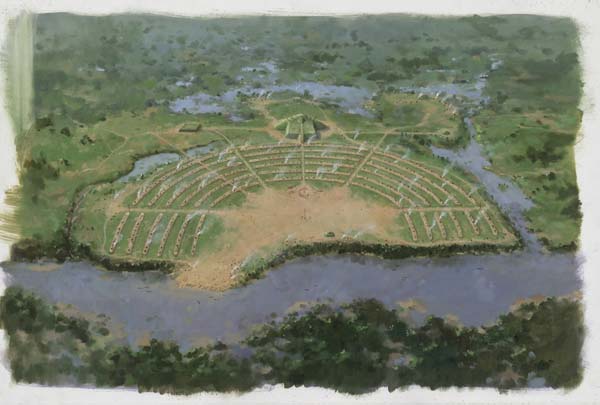
Courtesy of Martin Pate
Painting of Poverty Point. Pate, Martin (artist)
Located near the town of Epps in northeast Louisiana, Poverty Point is one of the most significant archaeological sites in the world. It is Louisiana’s only site to merit inclusion on the World Heritage List by the United Nations Educational, Scientific and Cultural Organization (UNESCO). Dating back to about 1700–1100 BCE, it represents the largest, most complex settlement of the Late Archaic period in North America. At Poverty Point, the American Indian inhabitants moved by hand about 750,000 cubic meters (nearly 981,000 cubic yards) of dirt to construct five earthen mounds as well as a set of six nested, semi-elliptical earthen ridges and a large flat plaza. Archaeologists estimate that an equal amount of earth was moved in preparing the landscape prior to construction and in maintaining the site. A sixth mound was added by another group of people in around 700 CE, about 1,800 years later. Poverty Point’s inhabitants also imported great quantities of raw materials, particularly stone, over great distances; these materials were used to make tools and other objects. It is impressive that such achievements were attained by a people who depended on hunting and gathering, not farming, as a means of survival.
Poverty Point is not the name given to the site by the people who built it and lived there. Archaeologists do not know what this group called its home, nor do they know the name of the tribe responsible for the earthworks. Long after the settlement had been abandoned by the American Indians, a cotton plantation named Poverty Point was established in the early nineteenth century on the property; the archaeological site is named after it.
Earthworks in Louisiana
Earthen mounds dot the landscape of eastern North America, and Louisiana has some of the oldest, best-preserved, and most impressive examples. The oldest mounds in the state, such as those at Watson Brake and on the campus of Louisiana State University in Baton Rouge, are about six thousand years old, but American Indians were still building and using mounds when Spanish explorer Hernando de Soto traveled through the area in 1542 CE. Although Poverty Point’s earthworks are not the oldest, they are among the largest. Mound A at Poverty Point is the second-largest constructed earthen mound in North America; it was built about 2,200 years before the largest mound, Monks Mound, which is located at the Cahokia site in Collinsville, Illinois.
Archaeologists cannot conclusively explain why American Indians constructed mounds. Some later mounds were used as cemeteries, and others were used as foundations or platforms for special buildings. Some archaeologists have suggested that early mounds may have served to demarcate territorial boundaries, to assert how powerful the leaders were, or to build a sense of shared community among participating builders. There is no clear evidence to indicate the functions of the mounds at Poverty Point.
For many years, archaeologists believed that earthen monuments like those at Poverty Point could only have been built by people who relied on farming to survive. It was assumed that people who depended on hunting, gathering, and fishing did not have sufficient resources to support such activities as mound construction. Many mounds were built by farming cultures, but some, such as those at Poverty Point, were not. Indeed, archaeological investigations at Poverty Point forced archaeologists to reconsider their assumptions about what prehistoric hunter-gatherers could accomplish.
Archaeologists first began to investigate Poverty Point in the early twentieth century. Clarence Bloomfield Moore excavated at the site in February 1913. Clarence H. Webb, a physician and avocational archaeologist, began exploring Poverty Point in the 1930s and was pivotal in research there for decades. Webb collaborated with a local enthusiast, Carl Alexander, as well as other avocational and professional archaeologists, including James A. Ford, who conducted research at Poverty Point in 1952–1955. Since then, many archaeologists have worked at the site, accumulating greater knowledge, but raising additional questions in the process. The story of Poverty Point is a continually evolving one.
Poverty Point Earthworks
Although the ages of all the mounds at Poverty Point are not precisely established, five are thought to be associated with the main construction episode from 1700 to 1100 BCE. These mounds are quite different in terms of size, shape, construction material, and construction technique.
The C-shaped ridge system at Poverty Point went unrecognized for many years, mostly because of its magnitude. The ridges are so large and topographically subtle that their true dimensions and spatial configuration could not be perceived easily from the ground. The diameter of the outermost ridge is roughly 1,250 yards (1.14 kilometers). It was not until 1953 that archaeologist James Ford identified the ridges in an aerial photograph. Archaeologists believe that the people of Poverty Point lived on the ridges. Although there is no unequivocal evidence of houses, daub (earth used as a construction material that was fired when the building burned) and postholes have been found on the ridges and abundant materials associated with day-to-day living (hearths, pits, earth ovens, utilitarian artifacts) are concentrated there, showing without question that people used the ridges intensively for hundreds of years. The ridges at Poverty Point are unique; no similar constructions are known anywhere else in the world.
The ridges enclose a 43-acre (17.4 hectares) flat expanse known as the plaza, which was long assumed to be part of the natural landscape. Archaeologists later determined that it was artificially created through filling and leveling. Recent geophysical investigations have revealed traces of rings between 82 and 206 feet (25 and 63 meters) in diameter under the ground, and excavations of these plaza rings have found large, deep postholes. Their significance remains unknown, but nevertheless it appears that there were large rings of posts in the plaza.
Life at Poverty Point
Poverty Point is located on Macon Ridge, overlooking the west side of the Mississippi River floodplain. Before the current man-made levee system, the Mississippi River often overran its banks, flooding the valley and creating a swampy floodplain habitat. The elevated ridge would have stayed dry during flooding and would have supported both hardwood and grassland habitats. This setting would have provided easy access to a variety of upland and bottomland resources (deer, small mammals, nuts, fruits and berries, fish, aquatic roots, and turtles) and to the Mississippi, Ouachita, and Arkansas Rivers, which were important for trade with other groups.
The greatest challenge of living at Poverty Point was probably that there was no nearby source of stone for tool-making or cooking. Indeed, the nearest local stone sources were 24 miles (40 kilometers) or more distant. Tons of raw materials—including steatite (soapstone), galena (lead ore), sandstone, hematite, magnetite, quartz crystal, and a variety of different kinds of cherts (sedimentary rocks such as flint)—were apparently brought in from sources nearly 700 miles away. How these natural resources were acquired, however, is not at all clear. No apparent Poverty Point “trade goods” were found in archaeological sites near the source areas. Were perishable items such as deer hides or dried fish traded for the items, or was some other kind of exchange mechanism in place? Or, did Poverty Point people acquire the materials themselves? Archaeologists do not yet know. These raw materials were used in the tools that performed all of the tasks necessary for survival: hunting, fishing, gathering and preparing food, building shelter, and creating earthworks.
Stone spear points (which are larger than arrowheads and predate the bow and arrow in the southeastern United States) were found in a variety of shapes and sizes at Poverty Point, and they—like other cutting, scraping, and drilling tools—are made of many kinds of chert. Plummets, which are highly polished, teardrop-shaped objects usually made of hematite or magnetite, are thought to have served weights for fishing nets or for looms used to weave textiles or basketry. Steatite and sandstone were gouged and ground to form large bowls for preparing food. Poverty Point is especially known for its polished and drilled stone beads and pendants, most notably its tiny, potbellied jasper owl pendants.
A common cooking technology of the time involved placing hot rocks in an earth oven, which allowed the rocks’ dissipating heat to slowly cook food. Because Poverty Point lacked a local source of stone, people there used the loess soil to make artificial rocks called Poverty Point Objects (PPOs) using the loess soil. These earthen cooking-balls were constructed by taking a small handful of moist soil and rolling it between the palms and fingers. The PPOs were then fired to harden them.
Although Poverty Point was unique with respect to the magnitude and geometric design of its monumental architecture, it was not the only settlement of its age that had earthen mounds or exotic raw materials. More than two hundred archaeological sites with similar kinds of artifacts—some with but most without mounds—have been found throughout the southeastern United States, from Memphis, Tennessee, to the Gulf of Mexico. The people who lived at these other settlements have been classified by archaeologists as having belonged to the Poverty Point culture; they were likely in contact with the people of Poverty Point and shared many of the same ideas and activities.
Visiting Poverty Point
On January 17, 2013, U.S. Secretary of the Interior Ken Salazar nominated Poverty Point for inclusion on UNESCO’s World Heritage List. It was inscribed on June 22, 2014, by UNESCO World Heritage Committee during a meeting in Qatar. The prehistoric earthworks joined the Taj Mahal, the Statue of Liberty, Stonehenge, the Grand Canyon, and the Great Barrier Reef, among others, on the list of 1,007 properties in 161 countries (as of 2014) designated as the most significant cultural and natural sites worldwide.
The State of Louisiana purchased a 400-acre section of the site in 1972 and opened Poverty Point as a public archaeological park. The World Heritage Site is open for visitation from 9 a.m. – 5 p.m. daily, except for Thanksgiving, Christmas and New Year’s days. Offerings include a museum, ranger-guided tram tours, a hiking trail, and frequent opportunities to take part in crafts or other educational events.
