Poverty Point Culture
This entry covers prehistoric Poverty Point culture during the Late Archaic period, 2000–800 BCE.

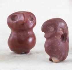
Photo by Jenny Ellerbe; courtesy of the State of Louisiana, Division of Archaeology
"Pot belly" owls recovered from the Poverty Point site.
Late Archaic period cultures continued trends established earlier: populations increased and people stayed longer at base camps. Still, across much of Louisiana, sites of this period are very similar to those of the preceding Middle Archaic period. The fishing-hunting-gathering lifestyle established in the Middle Archaic period was maintained, so stone points and other tools were similar to earlier styles. Mound building by Middle Archaic peoples ceased after 2800 BCE, and many Late Archaic peoples did not build mounds. However, the Poverty Point culture (1700–800 BCE) produced a massive mound-and-plaza site (the Poverty Point site) that would not be equaled in size and complexity until around 1000 CE. The Poverty Point culture is also distinguished from its predecessors by a marked increase in the amount of trade conducted, particularly in stone, and in the extent of its trade networks. While much exotic stone was fashioned into distinctive ornaments, the bulk of it (estimated at seventy-eight tons) was used to make tools. Some archaeologists think that the increased efficiency in fishing and gathering provided by these tools may have been the tipping point that allowed the local peoples to construct the largest and most complex mound site ever created by non-agricultural peoples.
Poverty Point Culture: Definition and Important Sites
At its most basic, Poverty Point culture can be defined as an exceptionally precocious mound-building culture that developed a remarkable and extensive trade in high-quality stone. Presumably, organic materials like feathers, hides, and wooden objects were part of the exchange, but, if so, the evidence has eroded away.
The heartland of the Poverty Point culture was in a limited area in northeast Louisiana. Its center, or core, consisted of the mound site itself, and a vibrant community of support sites extending out about 2.5 miles around the earthworks. Beyond the core, at distances of up to twenty-two miles from Poverty Point, were some sixty sites, mostly field camps, along with a few small residences. The field camps often contain just one or two tool types, suggesting people at the camps were processing specific foods available only in those locations. The ubiquity of exotic stone is demonstrated by the fact that tools at these camps often were made of the same imported, fine-grained rock present at Poverty Point.
Outside of this heartland were clusters of sites that formed other communities. These communities share some of the characteristics that define the Poverty Point culture. A few have mounds, although none approach the scale of the Poverty Point site, and the sites also contain imported stone, although again, not nearly as much as Poverty Point. Types of stone present, and styles of artifacts made from the stone, are used to gauge the degree to which a community was involved in the broader Poverty Point culture trade network. One might think that sites closest to Poverty Point would have the most similar artifact assemblages, with similarity dropping off with distance. However, this was not the case. For example, the community closest to Poverty Point, Bonne Idee–Bartholomew, had diverse stone tools, but ornamental items like beads were very rare.
Perhaps the site most closely related to the Poverty Point site is the Jaketown site, in west-central Mississippi. Jaketown did not have all the types of imported stone that Poverty Point did, but it had plenty. Jaketown was built on a half-moon-shaped point bar (the sand bar that forms at a river bend). Today, the surface features of the Archaic site are not visible, because they have been covered over by flood deposits. Recently, archaeologists took a series of soil cores across the site. The cores clearly showed that when Archaic period peoples occupied the Jaketown site, the people lived on a naturally formed series of ridges and swales (five and four, respectively) that look very much like the culturally constructed rings (six ridges and five swales) at Poverty Point. Because some of the dates from Jaketown are earlier than those from Poverty Point, there are suggestions that Jaketown provided the blueprint for Poverty Point.
Poverty Point Culture Artifacts
The Poverty Point culture is associated with an assemblage of artifacts that is found in its entirety only at the site itself. Some of the most iconic artifacts are Poverty Point Objects (PPOs). These were made from loess (very fine-grained, wind-blown silt)—the sediment underfoot at Poverty Point. PPOs are about the size of modern charcoal briquettes and they may have functioned similarly. When hot PPOs are used in earth ovens, they retain heat and allow for slow, dry cooking of fish, meat, and other foodstuffs. Archaeologists have done “experimental archaeology” to test whether or not this actually works—and it does. Clay objects similar to PPOs are found in many sites across the United States, from California to Florida. However, the collections from Poverty Point are distinguished by their abundance and by the diversity of shapes present.
Other clay artifacts include tubular pipes, Venus-like figurines, and a relatively few pottery fragments. Pottery may have been made locally, but some was imported from as far away as northeast Florida.
As noted, it has been estimated that some seventy-eight tons of exotic stone were imported into Poverty Point. The kinds of chipping debris found at the site indicate that most stone was imported as blanks—that is, the rough outer coating of the stone had been removed, and the stone had been chipped down to the point that it was ready to be shaped into a specific tool. Although there are a few new stone point styles associated with the Poverty Point culture, the vast majority were made in the same styles as the points produced before and after Poverty Point. Some archaeologists argue that the size and complexity of Poverty Point must have come about as a result of influences from outside the lower Mississippi River Valley, for instance from Mesoamerica. However, the continuity of styles of projectile points may be an indication that the Poverty Point site was built by and for local peoples.
Other types of stone tools include soapstone (steatite) and sandstone bowl fragments; iron ore (hematite and magnetite) plummets (possibly net weights); atlatl weights; tiny stone drills for bead-making; and celts, hoes, and adzes for digging and chopping.
Poverty Point is also well known for its ornaments. Stone, notably red jasper, was shaped into tubular beads and into animal forms; the “pot-belly” owl is another iconic Poverty Point artifact. Copper was also shaped into beads. The presence of bead blanks and beads that broke while the hole was being drilled indicate that many beads were made on site.
Daily Lives and Deaths
Analysis of food remains from the sites surrounding Poverty Point indicates a diverse diet. Fishing supplied the bulk of the protein. At one village site, more than 70 percent of the identifiable food bone was from fish. Nuts provided meat, flour, and oil, and local terrestrial and aquatic plants added carbohydrate-rich tubers, starchy seeds, and nutritious leaves to the diet.
It would be nice if archaeologists could confirm the dietary reconstructions with skeletal analysis. However, no burials have ever been found at a Poverty Point culture site. Bone preservation is poor in the loess that covers the main site, so burials may have dissolved away. On the other hand, burials may have been immersed in ponds or interred away from archaeologically visible base camps and mound sites, and so have escaped archaeologists’ notice.
There is little consensus on how and why the Poverty Point culture was able to create such a huge site and extensive exchange network. Through time, ideas have changed as more information became available. The site was once considered to have housed a chiefdom-level society fueled by corn agriculture, but so far, there is no evidence for chiefdom-level inequality or for the domestication of local (e.g., sunflower) or foreign (corn) plants. However, the village model is still one of the major working hypotheses: Poverty Point site was a huge, nucleated village, unlike anything that existed before or after it. It was constructed and maintained by egalitarian hunters and gatherers who were able to live in such a compact settlement because of the efficient way food was obtained in the surrounding specialized villages and field camps.
Another suggestion, based on the abundance of exotic material, was that the site was the location of a huge, region-wide trade fair. However, although tremendous quantities of material came into Poverty Point, very little left the site. Most recently, researchers have suggested that Poverty Point was a pilgrimage site. In this scenario, the abundance of stone was not the result of trading over vast networks; instead, the huge amount of exotic stone was brought to the site by pilgrims, and earthwork construction was an essential part of the pilgrimage experience.
Final Thoughts
The vast earthworks of the Poverty Point site were not surpassed in size until the Mississippian culture built Cahokia near St. Louis more than two thousand years later. Cahokia’s explosive growth may have been detonated by massive immigration. Poverty Point, in contrast, appears to have achieved its greatness with local labor and inspiration from the natural environment (however steeped in cultural connotations). Thankfully, the Poverty Point site will be preserved for future generations to study and appreciate. In 2014, it became the 1001st site on the UNESCO World Heritage List, a program that recognizes the world’s most important cultural and natural properties. Continuing archaeological research at the Poverty Point site and other associated sites will contribute to a better understanding of the Poverty Point culture.