Current Issue
Explaining Morgan City
A place of many raisons
Published: September 1, 2026
Last Updated: September 2, 2026
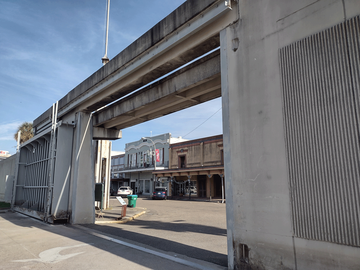
Photo by Richard Campanella
The floodwall in downtown Morgan City.
Most Louisiana cities, towns, and villages may be traced to an original raison d’etre—a reason for being, a rationale for their emergence, a story behind their siting. Alexandria and Natchitoches, for example, both arose at their respective sites on account of navigational impedances, namely the Red River rapids and a logjam further upstream. Relatedly, Lafayette, Mermentau, New Iberia, and Shreveport all mark the heads of navigation on their respective waterways at the time of their founding, while Arnaudville, Covington, Donaldsonville, Jonesboro, and Jonesville formed where rivers and/or bayous converge or diverge. New Roads, Cut Off, and Raceland emerged along shortcuts, and scores of other Louisiana communities materialized around crossroads or train stops.
Some raisons are reflected in town names, among them Lockport, Breaux Bridge, Midway, Abita Springs, Sulphur, and Junction City. Others operated in unison. Colonials sited New Orleans, for instance, at a good-enough harborage with high-enough banks, but only because a backswamp portage made one particular river crescent particularly accessible. Baton Rouge thrived as an administrative center, river port, and industrial site, but only because its location initially proved suitable for military defense.
And then there is Morgan City, which, I would argue, has the most multifarious siting story in all of Louisiana. Phrased another way, Morgan City has the broadest array of geographical reasons justifying its existence—even as a visit to this St. Mary Parish municipality may suggest otherwise, lying beneath dauntingly high floodwalls constraining the Atchafalaya River.
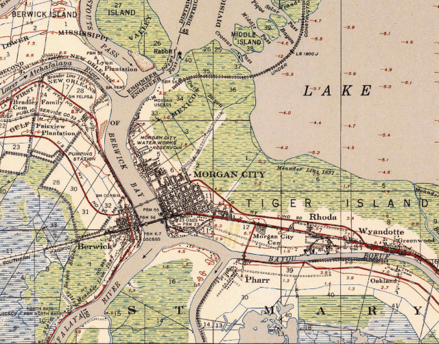
A 1935 USGS map of Morgan City. Courtesy of Richard Campanella
Once home to ancestors of the Chitimacha tribe, today’s Morgan City arose from geopolitical circumstances of the 1780s, by which time Spanish administrators of Louisiana had launched a policy of poblando la barrera—that is, populating the vast colony to form a defensible barrier between the British to the east and Mexico to the west. They did so by surveying parcels of land seized from displaced tribal members and granting them to European settlers—Spaniards if possible (such as those who settled New Iberia), else Catholics such as Acadian exiles from French Canada, or Anglo-Americans who shared Spain’s enmity for the British. As part of their poblando strategy, the Spanish in this era also reopened the transatlantic slave trade into Louisiana.
Among the incoming Anglo-Americans was a Pennsylvania-born surveyor named Thomas Berwick. In the 1780s, Berwick began working with Spanish authorities to lay out land grants in the Opelousas district and eventually settled with his family in the lower Atchafalaya region. In 1797, following his death, Berwick’s widow Eleanor Wallace Berwick and son Joseph received a grant for seventy arpents on a curvaceous natural levee understood at the time as the east bank of Bayou Teche, now the main channel of the Atchafalaya River. Being surrounded by lakes, marshes, and waterways loosely known as Berwick’s Bay, the natural levee (ridge) seemed practically like an island, and because of its population of bobcats, it gained the name Tiger Island. Other settlers secured grants or purchased tracts adjacently along this isthmus-like land bridge separating interior swamplands from estuarine marshes, through which passed the strait-like channel of the Atchafalaya River.
As political dominion of Louisiana shifted from Spain back to France and finally to the United States, settlers and enslaved people established farms and plantations along this strip, the largest of which, on Tiger Island, came into the possession of a Maryland-born doctor of French descent named Walter Brashear. All the while, Acadian settlers on the nearby Attakapas Prairie began raising cattle for shipment down Bayou Teche to the New Orleans market, making Tiger Island and adjacent Berwick’s Bay key transshipment points.
Morgan City has the broadest array of geographical reasons justifying its existence—even as a visit to this St. Mary Parish municipality may suggest otherwise, lying beneath dauntingly high floodwalls constraining the Atchafalaya River.
Seeking to streamline this conduit, Brashear invested in the Barataria & Lafourche Canal Company, which in 1829 began digging a navigation channel from today’s Westwego to Lockport (reached in 1841) and onward to Tiger Island. Enough people settled on or near Tiger Island to justify the opening of a Catholic chapel in 1843, and by 1849, to form a hamlet named St. Mary on the ferry-connected western bank of the Atchafalaya.
Also motivating this micro-urbanization (that is, formation of towns) was the 1830s–1840s removal of logjams up the Red River and at its confluence with the Mississippi, out of which discharged the Atchafalaya distributary. Steam vessels could now navigate throughout southcentral Louisiana, and they did so by passing through Berwick’s Bay—with Tiger Island on the east bank and St. Mary on the west.
By 1850, economic vectors from every direction converged around this key isthmus/strait-like portal. Cattle came from the west; cotton and cane from the north; natural resources from the swamp basin; imports from New Orleans to the east; and finfish and shellfish from the estuary to the south. Railroad investors took note and secured a state charter to build the New Orleans, Opelousas & Great Western Railroad, starting from Algiers and proceeding westward on trestles and ridges through Thibodaux, across Berwick’s Bay to Opelousas and onward to Texas and the western frontier. Work began in October 1852, reached Bayou Lafourche in 1854, and arrived at the Atchafalaya River in spring 1857.
The coming conveyance motivated Brashear family members in 1855 to subdivide lots on Tiger Island. They named the subdivision Brashear City and selected their scion Robert Brashear as its first postmaster. The earlier settlement of St. Mary, meanwhile, morphed into a cross-river community known as Berwick City. Economically invigorated by rail, river, and road traffic, Brashear City and Berwick City became bustling intermodal transshipment ports at the gateway of southcentral Louisiana.
The Civil War and its aftermath left the region with wrecked infrastructure, logjams, deluges, and epidemics, as well as the bankruptcy of the Great Western Railroad. Amid all the setbacks, one man saw in the twin cities a geographical opportunity like few others, as most regional traffic, be it latitudinal or longitudinal, had to pass between them to proceed. That man was Connecticut shipping magnate Charles Morgan, a proponent of intermodal transportation with a growing national reach. Morgan acquired the Great Western, expanded the Algiers railyards, added warehouses and industries, extended the tracks westward, and built ships to create Morgan’s Louisiana and Texas Railroad and Steamship Company.
Cattle, cotton, sugar, timber, Spanish moss, furs, feathers, and seafood could now flow through Brashear and Berwick cities heading east, as did migrants moving west to Texas and the frontier. “In a few years,” predicted an 1869 company petition to local leaders, “Brashear will be placed in competition with the largest cities in the state, if not in the union and the world.” In 1873, Congress designated Brashear an official Port of Entry, home to a federal tax collector and inspector of revenue. Three years later, the community of nearly two thousand residents renamed itself Morgan City in honor of the man who rejuvenated its myriad rationales.
In 1891, travel writer Catherine Cole visited Morgan City and came away impressed with its “tidy and progressive air . . . It is its seaport, and formerly great ships entered here via its Atchafalaya River and Bay. The storm of 1888 and last year’s fire swept the town, [but] since then new and handsome brick buildings have been erected, with many charming homes, [while] the bay shore . . . is lined with catboats, luggers and schooners [trading] pink conch shells, alligator hides; cups of carved coconut, skins of shark and pouches of pelicans. It is here the merchants ship fish to the far West, and white aigrettes and gray-plumaged terns to Paris” for the lucrative hat-feather industry. “The railroad is placed on a high trestle far above the town,” Cole recounted, while on the waterways, “Sicilian fishermen [call] out their wares.”
All the while, the consequences of that circa-1840 clearing of the Red/Mississippi logjams became increasingly vexing, in that augmenting water and alluvium caused flooding and sedimentation in the Atchafalaya Basin. Now finding a steeper path southward to the Gulf rather than southeastwardly past New Orleans, waters of the main channel of the Mississippi River might eventually avulse (jump) into that of the Atchafalaya. The result would be utterly catastrophic for southeastern Louisiana, leaving New Orleans on one long estuary with neither a port nor potable water. In theory, such an avulsion would do the opposite for southcentral Louisiana, making it the main portal of the Mississippi Valley, and turning Morgan City into New Orleans, so to speak.
Predicting the channel jump might occur around 1975, the US Army Corps of Engineers during 1954 to 1962 built the Old River Control Structure to steer 70 percent of the incoming flow down the Mississippi and 30 percent down the Atchafalaya. Nearly every community from Simmesport down to Morgan City and out to Venice directly depends on the engineering marvel at Old River.
By this time, Morgan City had added another raison to its d’être, as a resource-extraction and processing center for the shrimp and petroleum industries. Its population rose from 5,000 residents in 1910 to over 16,600 in 1970, during the oil boom; today, some 11,000 people call Morgan City home, while another 4,500 live in the Town of Berwick, formerly St. Mary. Both communities are encircled by ring levees and floodwalls, making them the largest Louisiana population center outside of greater New Orleans living in a “bowl.”
Their underlying geographies may be characterized as an island-like natural levee of a bayou forming an isthmus-like land bridge traversed by the banks of strait-like river channel—all set among a dizzying array of bays, lakes, swamps, marshes, bayous, passes, cutoffs, and canals. Morgan City’s siting stories, meanwhile, tell of a river port, bayou fork, ferry landing, crossroads, rail junction, basin bypass, and jumping-off point to resource extraction sites, including offshore oil wells.
No other Louisiana community has such a complex explanation.
Richard Campanella, a geographer with the Tulane School of Architecture and Built Environment, is the author of Crossroads, Cutoffs, and Confluences: Origins of Louisiana Cities, Towns, and Villages; Draining New Orleans; Bienville’s Dilemma; and other books. He may be reached through richcampanella.com, [email protected], or @nolacampanella on X.