Summer 2025
Gateway to Poste de Attakapas
An excerpt from Richard Campanella’s new book Crossroads, Cutoffs, and Confluences (LSU Press)
Published: May 30, 2025
Last Updated: August 29, 2025
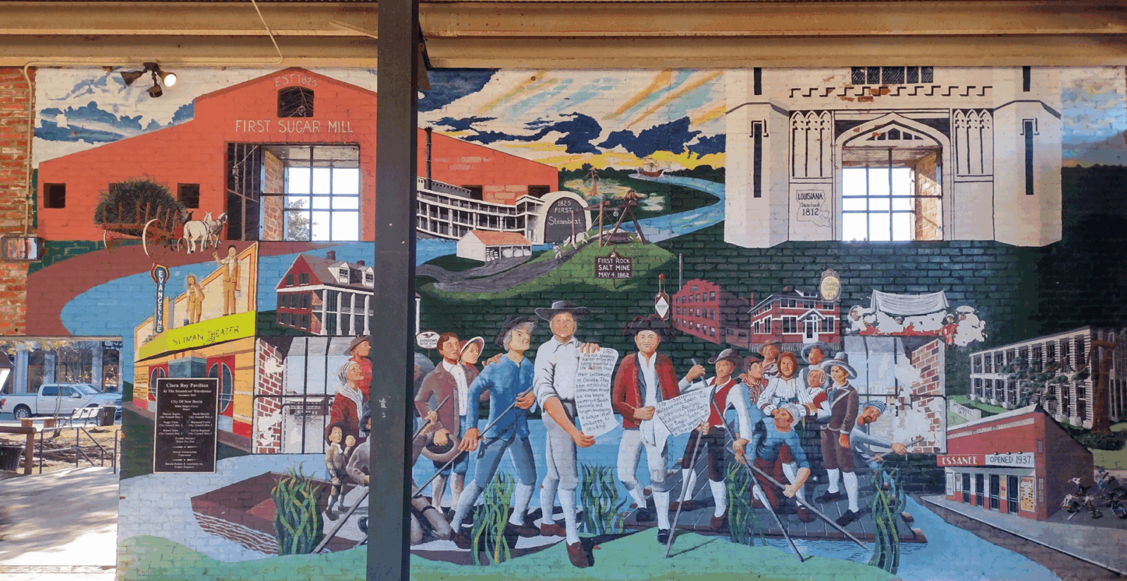
“Queen City of Bayou Teche,” New Iberia is Louisiana’s purest example of a Spanish town—in its siting, founding, naming, layout, and in the ethnicity of its first European settlers. Its populace today, however, is as much of Acadian, Anglo, African, and indigenous descent as depicted in this mural on an old warehouse wall overlooking Bayou Teche.
Photo by Richard Campanella
Richard Campanella’s Crossroads, Cutoffs, and Confluences tells the epic story of human settlement in Louisiana, unearthing the original geographical rationales for the formation of hundreds of cities, towns, and villages where most Louisianians live now. Campanella illuminates why these communities formed where they did, be they at river confluences, forks, crossroads, heads of navigation, ferry landings, shortcuts, portages, resource-extraction sites, or railroad stations, and explores other spatial factors that initially attracted settlers. Readers curious about the origins of Louisiana’s cities, towns, and villages can turn to Crossroads, Cutoffs, and Confluences for answers to that most fundamental question of human geography: Why are we here?
LSU Press
Home to the Opelousas, Attakapas, and Chitimachan peoples, Bayou Teche saw European settlement commence courtesy of the late 1770s Spanish policy of populating the Louisiana colony for military defense and economic development. The gateway to that western region had become known as the Poste de Attakapas, or simply the Attakapas (“man eater”), named for the most feared of its three resident tribes. It was the Chitimachans, however, who numerically predominated in the Bayou Teche region—until displacement relegated them to isolation or assimilation with incoming Europeans, among them Spaniards recruited from Málaga, Granada, and the Canary Islands.
Coordinating this settlement effort was Lieutenant Governor Francisco Bouligny, a determined officer who had helped establish Spanish rule in Louisiana and now oversaw Indian affairs as well as immigration policies. Bouligny’s superior, Governor Bernardo de Gálvez, thought it best to settle the newcomers close to New Orleans, a strategy that eventually spawned Galveztown, San Bernardo, and Gonzales. Bouligny favored a more dispersed strategy, eyeing the Ouachita region to the north and the Attakapas region to the west. Ouachita was deemed too risky, so Bouligny instead planned on leading twenty settlers from Málaga plus employees and slaves into the Attakapas region, namely Bayou Teche.
“Probably no group of immigrants received as much assistance in settlement as the Malagueños,” wrote historian Gilbert C. Din in describing Bouligny’s January 1779 expedition. But they were strangers in a strange land, new to all they saw. Heavy rain made matters worse—“fifteen days of Purgatory,” one soldier put it—as they slogged across the Atchafalaya. Upon reaching Bayou Teche in late February, Bouligny and his advisers scouted optimal sites for what he would call Nueva Iberia, the name indicating these new colonists were peninsulares, from the Spanish mainland, like Bouligny himself, as opposed to the isleños (islanders) Gálvez had been settling closer to New Orleans.
In mid-March, Bouligny selected a bend on Bayou Teche twelve leagues (thirty-six miles) up from its mouth, because it struck him as particularly beautiful and accessible, something he may have deduced from the presence of a nearby Chitimachan village. Despite persistent rains, workers made progress clearing banks and building huts—until the bayou overflowed and inundated the town site. All the while, Bouligny had come to understand that most land along Bayou Teche had already been titled, such that he would have to purchase it from colonists. The expedition had to pull up stakes and head upriver to find an alternative site, putting Bouligny in the position of explorer as well as a buyer on the real estate market.
In April he found a site that satisfied all requirements. It was located twenty- three miles above the first location, on the west bank of a promontory known as Petite Fausse Pointe. This hairpin meander, along an oxbow-like sequence of bayou bends, would force vessels to slow down while effectively doubling the length of the settlement’s waterfront. Importantly, it had a portage cutting across the subsequent meander loop that replaced fifteen miles of navigation with a mere two-mile walk. Nearby were freshwater lakes “filled with fish and game,” Bouligny noted, as well as prairie to the west for crops and cattle, and ample timber in the Atchafalaya swamp to the east. Better yet, the site had access to the marshes of the Vermilion Bay via Bayou Petite Anse (Little Cove), which could be developed into a sea harbor, and where a potentially useful salt dome (now Avery Island) was located. This spot was also just above Bayou Teche’s head of saline tides, a paramount attribute in regard to potable water and irrigation. What sealed the deal was that the real estate had a willing seller, in the person of Joseph Prevost dit Colette, who sold thirty arpents of frontage to Bouligny for 400 pesos. Because the move had been carried out during springtime high water, it showed that the new site for Nueva Iberia would be relatively safe from inundation—unlike the former site by the Indian village, now Charenton, which remains the home of the federally recognized Chiti- machan tribe today.
More Malagueños arrived and settled, as did some Germans, Irish, and others, but they did not ensure the success of Nueva Iberia. One of the guiles of settlement siting is that geographical advantages are all theoretical unless and until broader economic dynamics enliven them. A portage is worthless if nobody treks it; a harbor is just a riverbank if no vessels come to dock. For a while, that’s what happened at Nueva Iberia—or rather, what didn’t happen. There was not enough of a regional economy to impart value to this site, and local efforts to develop industries proved disappointing. Some Spaniards had been recruited to cultivate and process flax and hemp, but neither grew well along Bayou Teche, nor did corn and tobacco. Many Malagueños moved away from bayou life to tend to cattle on the prairie, and by the 1790s Nueva Iberia nearly failed again.
What saved the project was a subsequent influx of French Creole, Acadian, and Anglo settlers, who, with enslaved Africans, rendered the region productive. People and cargo in transit activated those site advantages Bouligny had discerned back in 1779, and the town he founded spurted to life. To the Francophones it was Nouvelle Ibérie, to Anglophones it was New Town, and to Hispanophones it remained Nueva Iberia. As the various ethnicities syncretized into Louisianians, they called their town New Iberia, which became the official name in 1847.
Excerpt from:
Crossroads, Cutoffs, and Confluences: Origins of Louisiana Cities, Towns, and Villages
by Richard Campanella
Hardcover, $49.95; Paperback, $34.95; 216 pp.
Louisiana State University Press (April 2025)