Magazine
Louisiana Lacunas
Why so few people along the Sabine and Pearl Rivers?
Published: February 28, 2025
Last Updated: May 30, 2025
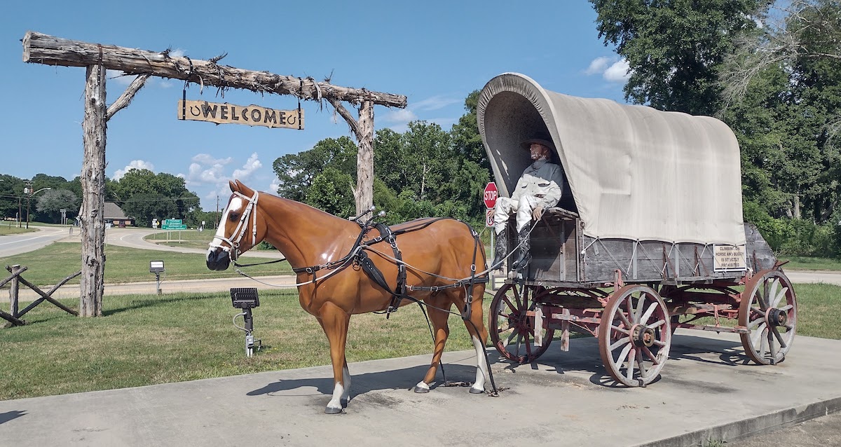
Photo by Richard Campanella
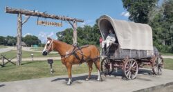
Gateway to Logansport commemorates the wagon trails that helped form this riverside town.
For a state transected by waterways and dominated by riverine settlement, it may seem confounding that two major rivers have, along their hundreds of combined bankside miles, precisely one incorporated Louisiana town. The Sabine and Pearl Rivers are lengthy lacunas in the human geography of the Bayou State, with few people, little industry or commerce, and hardly any agriculture fronting their murky waters. The question is, why? Or rather, why not?
This was not always the case. To Native people, both valleys were suitable enough, if not enticing. They built mounds near the mouth of the Pearl over 3500 years ago, and by the late 1600s, some seven hundred Acolapissas lived in six villages on the western channel of the river they called Talcatcha, meaning rock or stone. An English mapmaker later translated talcatcha as “pearl,” for the calcium accretions collected from oyster shells. “Pearl” got applied to the larger main channel to the east, which is where some Choctaw people lived into the early twentieth century, likely near present-day Indian Village Road in Slidell.
Likewise, far to the west, the Caddo and Attakapas tribes lived and traded up and down the river later named Sabine, the Spanish word for the cypress trees that covered this swampy basin. Known as the Sunrise People, Natives on the Louisiana side travelled the Atakapa–Coushatta Trace to trade with those on the Texas side, who were known as the Sunset People. This ancient pathway roughly followed today’s Highway 190, from DeRidder through Merryville.
Europeans arrived to Louisiana with different imperatives, ones based on permanent occupancy, private land ownership, resource extraction, and wealth production. When viewed through those lenses, the Pearl and Sabine rivers looked rather uninviting, if not entirely useless. Both basins were relatively small and narrow; that of the Pearl extended only into central Mississippi, and that of the Sabine barely up to present-day Dallas. Their interiors were covered with the sort of piney woods that would not attain economic value until the railroad and lumber era of the late 1800s. Their soils comprised the compacted clays of the Pleistocene Terrace, generally unsuitable for farming, much less commodity plantations. Why settle in basins with little economic promise?
Moreover, where could you settle? “The swamps skirting this river for eight or ten miles from its mouths,” writes Samuel R. Brown of the Pearl in his Emigrant’s Directory (1817), “are too subject to inundation to admit of extensive settlements,” while its bottomlands are “covered with a heavy growth of cypress trees [and] almost impassable.” Note that Brown wrote “mouths”: the lower Pearl furcated into braided channels, each of which meandered widely and dispersed sediment broadly, like the Atchafalaya, rather than shoring up natural levees, like the Mississippi. Vegetation trapped more sediment particles, resulting in a wide swampy bottomland strewn with watercourses and devoid of fertile ridges. Worse yet, the Pearl was tough to navigate, for its twists and turns in the lower portion, and for the “rafts of driftwood” blocking interior reaches. As a result, the few miniscule early settlements on the Pearl’s Louisiana bank—Lima, Gordon Town, Violin, and Lee’s Creek—were little more than ferry connections to the more solid east bank, which developed two better-suited landings, Gainesville and Pearlington in Mississippi. Indeed, no village, town, or city would ever materialize on the Louisiana bank. Bogalusa comes close, but that Washington Parish city had been established as a railroad town for the timber industry, and to this day, has zero frontage on the Pearl. Even the St. Tammany Parish town of Pearl River is not truly on the Pearl River.
The Sabine and Pearl Rivers are lengthy lacunas in the human geography of the Bayou State, with few people, little industry or commerce, and hardly any agriculture fronting their murky waters. The question is, why? Or rather, why not?
Circumstances on the Sabine River mirrored that of the Pearl. Its bankside morphology was either too swampy, too steep, or too inaccessible. Its channel was sinuous, occasionally narrow, prone to shoals, and at one point, liable to develop “rapids at low stage of water,” according to an 1840s state lands map. In his 2012 article “Water and Power: The Sabine River Authority of Louisiana,” published in Tulane Environmental Law Journal, archeologist Ryan M. Seidemann characterizes the Sabine as “both a blessing and a bane” to those living in its vicinity, “prone to massive, devastating floods [and] too treacherous to support substantial steam travel.” The Louisiana side of its mouth, described as “soft sea marsh” and “deep sea marsh” on the 1840s map, was all but uninhabitable.
The Texas side of the Sabine, on the other hand, was sufficiently elevated to host two riverside settlements, Orange and Port Arthur, which together usurped the energy out of any settlement gaining traction on the Louisiana side. For example, some people settled on the high bank known as Niblett’s Bluff, which was once the crossing point of the Old Spanish Trail. But once the Louisiana Western Railroad bypassed this community in favor of connecting Vinton, Louisiana, directly with Orange in Texas, Niblett’s Bluff faded fast. The railroad company did install a nearby station on the Sabine River, at “a very pretty and pleasant location, with timber and prairie interspersed,” according to an observer cited in William Henry Perrin’s Southwest Louisiana: Biographical and Historical in 1891, but it too petered out. Expressing surprise at the lack of residents even then, the observer mused, “Why it has not a good school and church facilities, with all other necessary business houses, seems to be an unanswerable question.”
Another Sabine River settlement attempt occurred at the Old Coushatta Crossing, where freebooter Philip Nolan had once smuggled Spanish-bred horses along “Nolan’s Trace” to points east. In 1807 an Ohio doctor named Timothy Burr built a cable-strung barge ferry at this crossing, and later a gristmill, sawmill, and cotton gin. The settlement became a defensive position during the Civil War and endured until 1937, when the Burr Ferry Bridge was built. An interpretative sign at the site today describes historic Burr’s Ferry as “the Back Door of the United States,” but few of those passing through decided to remain, especially after the bridge allowed traffic to bypass the bankside settlement. There’s still a tiny community named Burr Ferry today, but it’s no longer on the Sabine River.
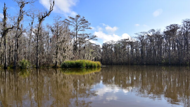
The Pearl River in Louisiana, near the border of Mississippi. Photo by Pedrik via Flickr
The Sabine settlement lacuna has an interesting antecedent. Spanish authorities in the early 1700s viewed the land between the Sabine River and the Arroyo Hondo/Calcasieu River as the easternmost flank of New Spain. French officials, on the contrary, understood the Sabine to form the westernmost edge of their Louisiana colony. To everyone else—Natives, African maroons (escaped slaves), mestizos, trappers, stragglers, rogues—the Sabine region was an ungoverned sanctuary, where freedom could be found amid the risk of wilderness living. The boundary dispute persisted into the early 1800s, by which time the United States contested Spanish Mexico over the zone. In 1806, both parties agreed to treat it as a demilitarized neutral ground, “lying between two sovereign nations,” as historian J. Villasana Haggard puts it in a 1945 article for Louisiana Historical Quarterly, “but under the authority of neither.” The so-called Sabine Free State became Louisiana’s wild west, where ruffians outnumbered settlers, where settlers were considered squatters, and where neither law nor order prevailed. That era ended when Spain and the United States signed the Florida Purchase in 1819 and ratified it in 1821, firming up the last of Louisiana’s state border disputes. But the century-long liminal era had the effect of deterring and delaying settlement, and coupled with inconducive hydrology, helps explain the Sabine population lacuna.
The only exception is Logansport in Desoto Parish, which had been founded as a ferry landing in 1830 by one Dr. Logan, and gained the name Logansport when its post office opened in 1848. Now the only incorporated municipality on the Louisiana side of the Sabine, the Town of Logansport bucked the trend for a number of reasons. It was located just beyond the old Sabine Free State, and was thus minimally affected by its associations. Its terrain abetted development as a river port, being up on a flat bluff with sloping banks. Its stretch of the Sabine flowed in an unusually straight channel, better for navigators, and its channel was deep enough most of the year to enable vessels to arrive and dock. The site also benefitted from overland trekkers heading west on stagecoach roads, so much so that a commemorative covered wagon now stands at the town gateway. Logansport today, home to 1,340 residents, has bridges, railroads, a timber industry, and an industrial services center for the extensive oil and gas drilling on the nearby Haynesville–Bossier Shale Play.
Ten miles downriver, another energy-related project drastically altered the Sabine River valley, and in the process, obliterated bankside settlements, further explaining the Sabine lacuna. The idea arose in the 1930s, when regional interests viewed the Sabine as a source of hydroelectric power, water storage for industrial use, and recreation. In the 1960s state authorities in Texas and Louisiana expropriated a number of rural communities, one of which was named Toledo, located on a bend of the Sabine which engineers had selected for the dam. They dubbed the project Toledo Bend, and the name stuck—even as Toledo and its neighboring communities were destroyed.
The Toledo Bend Reservoir, opened in 1969, ranks as one of the most draconian transformations of the Louisiana landscape. Not coincidentally, the Pearl River has also seen its share of massive alterations, in the form of locks, dams, and reservoirs in central Mississippi, including the controversial “One Lake” proposal in Jackson, which aims to reduce flooding in Jackson through more damming. Had the Sabine or the Pearl been able to attract more settlers and form more bankside towns, their valleys would surely have had very different fates.
Richard Campanella, a geographer with the Tulane School of Architecture, is the author of Draining New Orleans, Bienville’s Dilemma, and other books. This content is drawn from his upcoming book, Crossroads, Cutoffs, and Confluences: Origins of Louisiana Cities, Towns, and Villages (Louisiana State University Press, 2025). He may be reached through richcampanella.com, [email protected], or @nolacampanella on X.