Gone But Not Forgotten
Louisiana’s small cemeteries at risk in changing landscapes
Published: November 29, 2022
Last Updated: March 22, 2023
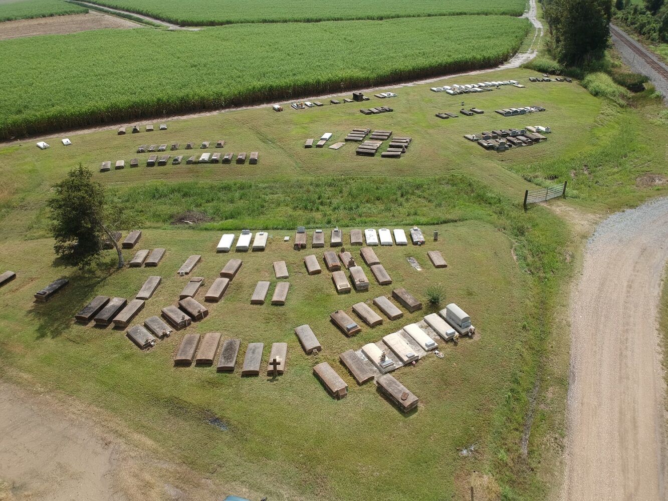
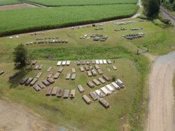
Photo by Brian M. Davis
False River Station Cemetery, Pointe Coupee Parish.
“There’s a million times more dead than living and the dead are dead a million times longer than the living are alive.”
Flannery O’Connor, The Violent Bear It Away
What does a cemetery look like? The answers are as numerous and varied as our vernacular culture. Some cemeteries feature granite and marble markers or concrete vaults to denote and protect the grave. More modern cemeteries may require bronze plaques mounted at ground level, to be a convenience for mowing. Some look like an earthen mound, an indentation in the grass, or a stand of trees in an otherwise empty field. Some might look like nothing at all, giving no clues as to what lies just below the ground. But cemeteries continue to define our religious, social, and socio-economic identities long after we are gone, or at least as long as the marker survives—if there is one.As executive director for the Louisiana Trust for Historic Preservation, I travel highways and backroads in all sixty-four parishes, providing technical assistance to save historic places representing our diverse culture. Louisiana has thousands of unmarked, lost, or abandoned graves across the state. Although they may occur anywhere, abandoned cemeteries are especially prevalent in areas where the population has significantly decreased, such as former agricultural or sawmill communities. When there are no descendants or even communities left to care for a cemetery, nature quickly begins to reclaim the land and a graveyard can become forgotten, along with its information. This can lead to the unintentional disturbance of burials and desecration of a sacred space.
In 2008, the Louisiana Legislature passed Revised Statute 25:914, establishing the Louisiana Register of Historic Cemeteries, in an effort to identify cemeteries at risk of being lost. This database would consist of cemeteries at least fifty years old or containing the burial of a person of significance or containing structures of architectural significance. Due to the dire economic landscape of the Great Recession, no funding was provided at that time to establish the program. Fourteen years later, the Louisiana Register of Historic Cemeteries remains only a concept on the legislative books.
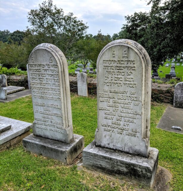
The deceased in some Delta parishes were taken across the river for burial in higher ground. Regina Deutsch was born in Bavaria, died at twenty-five in 1855 in Waterproof, Tensas Parish, and was buried in Natchez. Photo by Brian M. Davis.
In contrast, the Texas Historical Commission launched a similar designation in 1996 for Historic Texas Cemeteries, with a nominal application fee and input from the general public. Over 2,300 historic cemeteries have been designated as such by the publicly funded state agency. These are accessible to the public through the Texas Historical Commission Historic Sites Atlas, along with locations of historic markers, National Register properties, and courthouses.
Common use of contemporary tools such as DNA testing and online research and networking point to a powerful and ever-present human desire to discover more about our past and connect to our kin. The Louisiana Register of Historic Cemeteries public database of cemetery locations could bring descendants back to visit the land of their ancestors; it could foment the stewardship of long-neglected cemeteries, markers, and vaults. The database could also offer benefits to industries such as real estate, tourism, timber, agriculture, utilities, pipelines, and even public works and the Louisiana Department of Transportation and Development. Access to a reliable record of the locations of human burials when planning a project means fewer surprises and expenses once work gets underway, while preventing the desecration of human remains.
The residents of our region have historically sought out high ground for burials, including the natural levees along rivers and bayous. The precedent was set by prehistoric Indigenous communities, but all the inhabitants who followed understood the wisdom of the practice—some even burying their dead on top of prehistoric Native American mounds. Locating burials out of the floodplain lends greater reverence for the deceased, but also protects against damage to the marker and disturbance of the burial.
At Fleming Cemetery in Jean Lafitte, historic burials huddle around and on top of a Native American mound. Photo by Brian M. Davis.
Burying loved ones out of the floodplain was even more important before construction of the modern levee system. In flood-prone areas of Tensas and Concordia Parishes, wealthier families in the nineteenth and early twentieth centuries had the means to be buried in the higher ground across the Mississippi River, in Natchez. Less affluent families were buried on ground next to their rural church. The Delta region has numerous sites where the church is abandoned or no longer standing, leaving little but memory to denote the cemetery at the edge of a field.
Groves of trees on the edge or in the middle of a field can sometimes signify a cemetery, Native American mound, or remnants of a former structure. One culture’s traditions of marking a burial with a tree, shells, glazed brick, ironstone, petrified wood, and other readily available materials may not be recognizable by other cultures as a grave marker. This could lead to the unintentional removal or loss of the marker and disturbance of the burial. In some cases, the presence of recognizable historic cemeteries on top of a Native American mound was all that prevented the prehistoric earthworks from being used as roadfill by the highway department in the early twentieth century.
Indeed, we often hear of the discovery of unmarked graves in conjunction with construction projects. For example, in 2006, fifteen historic unmarked graves were discovered in southeast Ouachita Parish, in the right of way for a highway expansion. An adjacent Native American mound still supports several marble markers dating back to the 1850s, before the modern levee system was constructed. While this cemetery can be found on a 1940 topographic map of the area, by the time a subsequent map was published in 1957, nothing was visible to denote the burial ground.
An example of a rediscovered Black cemetery can be found on the Anchor Plantation in Catahoula Parish. The property has been in the current owner’s family since 1898 and is leased for corn and soybean farming. On the natural levee overlooking the Tensas River sits a narrow strip of trees, which awkwardly interrupts the long till rows. If visitors to the site traipse into the underbrush and poison ivy, they will find five headstones that identify the grove of trees as a cemetery. A closer look reveals rows of indentations in the ground, where scores of burials lie unmarked—at least, without the markers of our modern tradition. Perhaps wooden markers, fences, or plants used to remember the deceased have long faded away.
The Anchor Plantation cemetery also contains three marble tablets that denote the resting place of soldiers, including Richard Wilson and Isaac Evans, who served in the Sixth Regiment, US Colored Heavy Artillery. A little further downriver and outside of the rectangular grove of trees, the marble tablet of Theodore Joshua Randal sits at the base of a large hackberry tree. At the time of the Civil War, these three men were enslaved at Anchor Plantation. After learning of the Emancipation Proclamation, they escaped to Natchez and gained their freedom by joining the Union Army. Their military headstones represent an important chapter in American history and the determination to fight for freedom and equality at all costs. The owner of Anchor Plantation is working to carefully remove vegetation to the ground level, so ground-penetrating radar may be used to determine the location and number of burials. The family plans to dedicate a marker in the future, to bring recognition and respect to those in this once-forgotten cemetery and their descendants. A statewide database would make these stories from the Anchor Plantation cemetery, and thousands more like it, available to the public, enriching our understanding of Louisiana history.
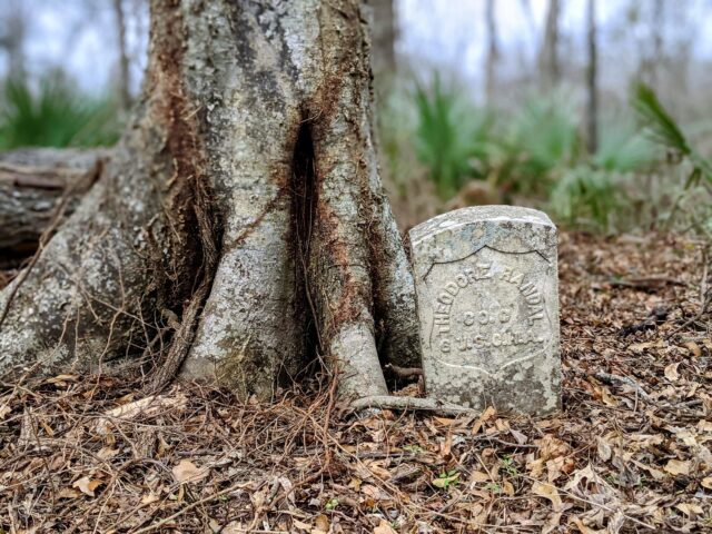
This stone at the Black cemetery at Anchor Plantation, Catahoula Parish, commemorates Theodore Joshua Randal. Randal was born in Bladen County, North Carolina, and later enslaved at Anchor Plantation. He escaped to Union-controlled Natchez and gained his freedom by enlisting with the Sixth Regiment of US Colored Heavy Artillery. Photo by Brian M. Davis.
The variance in burial markers around Anchor Plantation raises the question: What is the lifespan of physical reminders of a cemetery? In healthy towns and cities, and with regular care, cemeteries could last for several centuries. Without regular maintenance, shifting soil, storms, vegetation, and other factors will eventually begin to break down the materials used to remember loved ones. Lack of maintenance is one of the leading causes of cemeteries being lost and forgotten. After several generations have passed, will descendants retain a strong enough connection to those ancestors to tend to their graves? Will those descendants even live in the area?
In what was once the community of False River Station in Pointe Coupee Parish, close to two hundred graves lie at the edge of sugar cane fields, where a gravel road crosses the railroad tracks. A topographic map from 1939 shows numerous buildings in the area, where only cane fields stand today. The last houses from this sawmill town adjacent to the cemetery were inhabited into the 1970s. Artist Henry Watson and several other members of the Wiley United Methodist Church look after the graves of their ancestors and keep the grounds manicured. The church is located a mile and a half from the cemetery, and with the congregation getting older and smaller, Watson worries about who will tend to the grave of his grandfather and his contemporaries in the future.
Lack of maintenance is one of the leading causes of cemeteries being lost and forgotten. After several generations have passed, will descendants retain a strong enough connection to those ancestors to tend to their graves?
It’s not uncommon for cemeteries to outlast their communities, particularly in rural areas. And, as with prehistoric sites, these burial grounds can offer striking insights to the customs and values of the former inhabitants. One example is the town of Sparta, which was established in 1849 as the original seat of Bienville Parish. Pine forest was cleared to construct a courthouse, public buildings, churches, houses, a school, and even a racetrack. The downfall of Sparta began in the 1880s, when two railroads were constructed in the area and bypassed the community. In 1892, an election was held to reconsider the location of the parish seat, and Arcadia received the most votes. Parish records were moved; postal service was eventually discontinued; and by the late 1920s, a Black church, one house, and a cemetery were all that remained at Sparta. Today the pine forest has reclaimed the former town, leaving the Old Sparta Cemetery. Visitors to the cemetery will find a metal-roofed shed for reunions and maintained grounds, surrounded by a chain-link fence. A fence also separates the Black and white burial grounds—typical of cemetery layouts from the antebellum, Reconstruction, and Jim Crow eras.
Lost or unmarked burials are not just a rural occurrence. Dr. Gary Joiner, Chair of the Department of History and Social Sciences at Louisiana State University–Shreveport, along with his students, recently discovered what could be Shreveport’s oldest historic burial ground, in a block adjacent to Oakland Cemetery. Through the help of ground-penetrating radar and a historic map in the Caddo Parish records, they documented twenty-seven graves from the 1830s and early 1840s (they were even able to identify fourteen of the individuals). The site had once been the William and Mary Grave Yard. By the 1870s, it had been covered over with new home construction; a 1935 Sanborn Fire Insurance Map of Shreveport shows thirty-four residences and two stores on that block. The site is within the St. Paul’s Bottoms Historic District, which received designation on the National Register of Historic Places in 1984. Over time, however, many structures in the neighborhood were lost to neglect and demolition from code enforcement. No structures remain on that block. Funds have been raised to construct a metal fence and gate around the former cemetery. Dr. Joiner says the discovery underscores what he teaches his students: “The absence of a positive is not a negative.” In this case, just because you don’t see a grave marker doesn’t mean there’s no grave.
The situation of unmarked graves is not as uncommon as you may think—and it can impact not only historic burials but also recent ones. A few years ago, I was contacted by a woman whose uncle had been buried on her family’s property in Ouachita Parish. At the time of burial, the family did not have funds to purchase a headstone. A number of years later, members of the family sold the property with the unmarked grave, and the woman was concerned that the land could become a residential development that would disturb the burial. I connected her with the Louisiana Attorney General’s Office, where she learned of their 2008 legal opinion supporting access by relatives and friends to isolated cemeteries, for the purpose of visitation and maintenance of graves.
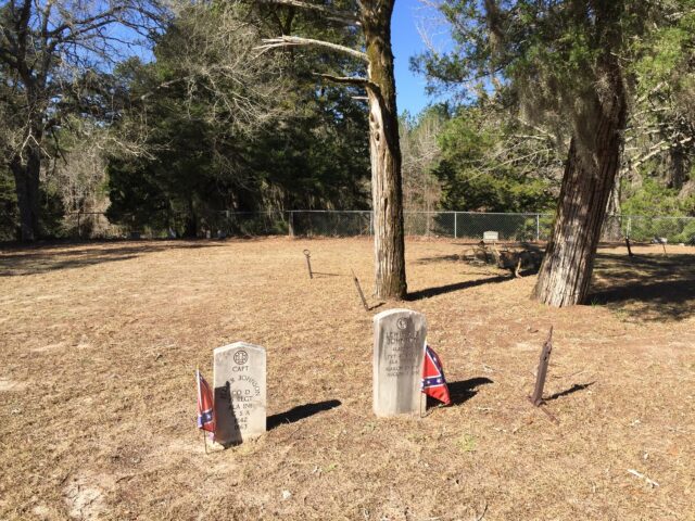
Even in death, there was separation of the races. A fence divides the Black section from the white section in Old Sparta Cemetery. Photo by Brian M. Davis.
Given what our state has witnessed in terms of coastal erosion and intensifying storm damage in recent years, it is reasonable to wonder about the impacts of climate change on grave sites. In their award-winning 2017 book, Fragile Grounds: Louisiana’s Endangered Cemeteries, Mary H. Manhein and Jessica H. Schexnayder examine the history of and threats faced by cemeteries in the coastal plain of our state. They featured two cemeteries in Leeville, in southern Lafourche Parish, both established during a yellow fever epidemic in 1905. Today, Leeville/Lafont Cemetery sits among hurricane debris, on the edge of Old Highway 1. A concrete slab holds the remaining graves from sinking into the bayou, as many burials have done in the past. With subsidence and sea-level rise, the back side of the slab now rests below the water line, where small blue crabs scurry. Stone and metal crosses that once topped burial vaults now lie twisted and broken, as does the historical marker that tells of three Leeville residents who purchased land for the cemetery in June 1905.
Across Bayou Lafourche, at the intersection of the Southwest Louisiana Canal, parts of the Lefort Cemetery remained above the water line until August 2021, when Hurricane Ida made landfall thirteen miles to the south. What remains of brick vaults are now underwater. Though these two cemeteries are now casualties of climate change and other manmade factors, we could at least establish a functioning database that identifies the locations of the Lafont and Lefort Cemeteries, helping to prevent their disruption in the future by—for example—dredging barges.
How do we help ensure that burials are identified, protected, and held sacred into the future? The Louisiana Legislature has the opportunity in the next fiscal session to fund the Louisiana Register of Historic Cemeteries program. Once established, nominations meeting the guidelines would be submitted by the general public to the Louisiana Division of Historic Preservation. In conjunction with the Louisiana Division of Archaeology, submissions would be considered for approval by a review board and then added to the public database, with links to historic photos, maps, obituaries, oral histories, and other information supporting the case for each listing. It will then be up to the general public to make site nominations to the program and let others know about the location and protection of historic cemeteries around our state.
For more information on legal rights and laws for Louisiana cemeteries, visit Louisiana Cemetery Board – Attorney General Opinions at lcb.state.la.us/ago.html.
Division Of Archaeology – Cultural Resource Management: Cemeteries & Burials at crt.state.la.us/cultural-development/archaeology/CRM/cemeteries-burials/index.
For an example of a statewide database of historic cemeteries, see Texas Historic Sites at atlas.thc.texas.gov.
Brian M. Davis is executive director of the Louisiana Trust for Historic Preservation. Based on his family farm in Ouachita Parish, he connects the dots with preservation projects in all sixty-four parishes.