Geographer's Space
Is Tiger Stadium the Center of Louisiana?
Here's where you can find the center of balance around which the population of Louisiana is evenly distributed
Published: August 17, 2015
Last Updated: September 13, 2022

Like any measure of central tendency, centroids have a peculiar way of characterizing all of us and none of us at the same time. Population centroids thus often end in unpopulated areas, such as the Missouri Ozarks. Florida’s population centroid is actually not in Florida; it’s in the Gulf of Mexico, due to the Sunshine State’s boomerang shape.
Centroids are fine tools to capture complex shifts of millions of data with a single datum point. But of course they don’t tell the full story. Centroids cannot distinguish between decline and growth, only aggregate shifts. For example, a centroid for a high-risk coastal parish may nudge inland not because people have actively moved away from the coast, but because people decided not to return to coastal areas that flooded. It also takes a lot to move a centroid, as micro-scale shifts in one area are usually offset by similar shifts elsewhere.
Like any average, defining the “denominator” before calculating centroids is essential. New Orleans proper versus metro New Orleans, for example, will have two different centroids. The geographer must also use the finest-grain—that is, highest spatial resolution—demographic data to determine centroids, since coarsely aggregated data produce a wide margin of error.
With these qualifiers in mind, where is Louisiana’s population centroid, and how has it moved through time? We cannot identify it for 1790 and 1800, because the U.S. had no business counting people in a foreign country at the time. The 1810 U.S. Census, the first after the Louisiana Purchase, puts Louisiana’s population centroid somewhere in St. Charles or St. John the Baptist parishes, indicating the preponderance of settlement in the New Orleans and lower river region at a time when present-day northern Louisiana was largely empty. By the Civil War the Louisiana population centroid moved into the Baton Rouge area, where, remarkably, it has remained ever since, as population growth to the north and west has been generally counterbalanced by comparable growth in the southeastern corner of the state. It should be noted that these estimates are based on parish-level demographics, which are admittedly coarse-grain and preclude precise centroid measurement.
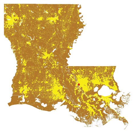
Residents of Louisiana (shown in yellow dots) are evenly distributed to the north, south, east, and west of a theoretical point in southern Baton Rouge (red dot), near Tiger Stadium, known as the population centroid. Map and analysis by Richard Campanella.
Today, we have census data mappable at the block and block-group level, which allow for much more precise centroid positioning. In 2000, the 4.4 million people of the Bayou State were evenly distributed around a spot on Ben Hur Drive just off Nicholson Drive in southern Baton Rouge, a little more than two miles southeast of LSU’s Tiger Stadium.
Centroids are also useful to capture if and how different sub-segments of the population settle. When we compare white Louisianians and African Americans, we see the same pattern: the white state centroid was located on the River Road straight south of Tiger Stadium by 3.5 miles, whereas the black centroid was only 2.5 miles to the southeast of the white centroid. For a state that spans over 52,271 square miles and for two populations who tend to live apart, these are remarkably consistent centroids. They speak to the fact that Louisiana for over 200 years has remained essentially riverine and coastal in its human geography, and the principal region of colonial-era development remains the demographic core zone to this day.
Even hurricanes Katrina and Rita, which led to the displacement of more than a hundred thousand residents mostly to the east and south of the 2000 centroid, only slightly nudged the 2010 population—by one mile, to the north and west, still within sight of Tiger Stadium.
When we zoom in to the New Orleans metro area, however, we start to see more significant shifts. Take, for example, the ten miles on either side of the 80-mile-long Interstate 10 corridor from downtown New Orleans to downtown Baton Rouge. In 2000, a total of 1,537,366 people lived within this strip. Their centroid (or fulcrum, given the elongated shaped of our study area) was around Clearview Parkway in Metairie: 50 percent of those 1.5 million folks lived downriver of Clearview, and the other half live upriver of it, all the way to Baton Rouge.
By 2010, that same swath was home to 1,423,015 people, and they were balanced on either side of Williams Boulevard in Kenner, four miles to the west of the 2000 balance point. Keep in mind it takes a lot to budge a centroid, and four miles over a span of 80 miles of largely uninhabited swamp is substantial.
We also see revealing centroid shifts when we zoom in on the contiguous urbanized New Orleans metropolitan area south of Lake Pontchartrain. In 2000, five years before the flood, there were 1,006,783 people living within this space, of whom 512,696 identified their race as white; 435,353 as black; 25,941 as Asian; and 50,451 as having Hispanic ethnicity. Five years after the flood, these figures had changed to 817,748 total population, of whom 416,232 were white; 327,972 were black; 27,562 were Asian, and 75,397 were Hispanic. (Figures do not sum to totals because some people chose two or more racial categories, other declined the question, and Hispanicism is viewed by the Census as an ethnicity and not a race.) These metro residents, as whole and by racial/ethnic group, universally shifted their centroids westward and southward during the five years before and after Hurricane Katrina. What accounts for these shifts is the fact that the eastern half of the metropolis bore the brunt of the Katrina flooding, as the storm’s surge arrived via its canal-scored eastern flank. The ensuing flooding meant populations there were less likely to completely reconstitute, which thus nudged centroids westward. Robust return rates in unflooded uptown also aided the trend.
We can learn a lot—though by no means everything—about population geography through centroid mapping. There is also an intriguing appeal to the notion of thousands or millions or even billions of people distributed unwittingly around a certain theoretical spot, one that is oftentimes curious or counterintuitive. The world population centroid, for example, is located north of the rugged Himalayas, reflecting the enormity of the populations of China and India. And if you really want to get away from it all, go to Easter Island in the south Pacific, which is near the world’s “anti-centroid,” as far as you can get from the bulk of humanity.
And while Tiger Stadium, contrary to the hunch of many LSU Tigers fans, may not be the center of the universe, it is pretty close to being the centroid of Louisianians.
—–
Richard Campanella, a geographer with the Tulane School of Architecture, is the author of Bienville’s Dilemma, Lincoln in New Orleans, Geographies of New Orleans, and Bourbon Street: A History. He may be reached through richcampanella.com or [email protected]; and followed on Twitter at @nolacampanella.