Looking Deeper at Poverty Point
Preservation-conscious technologies marry exploration and stewardship
Published: August 30, 2022
Last Updated: March 22, 2023
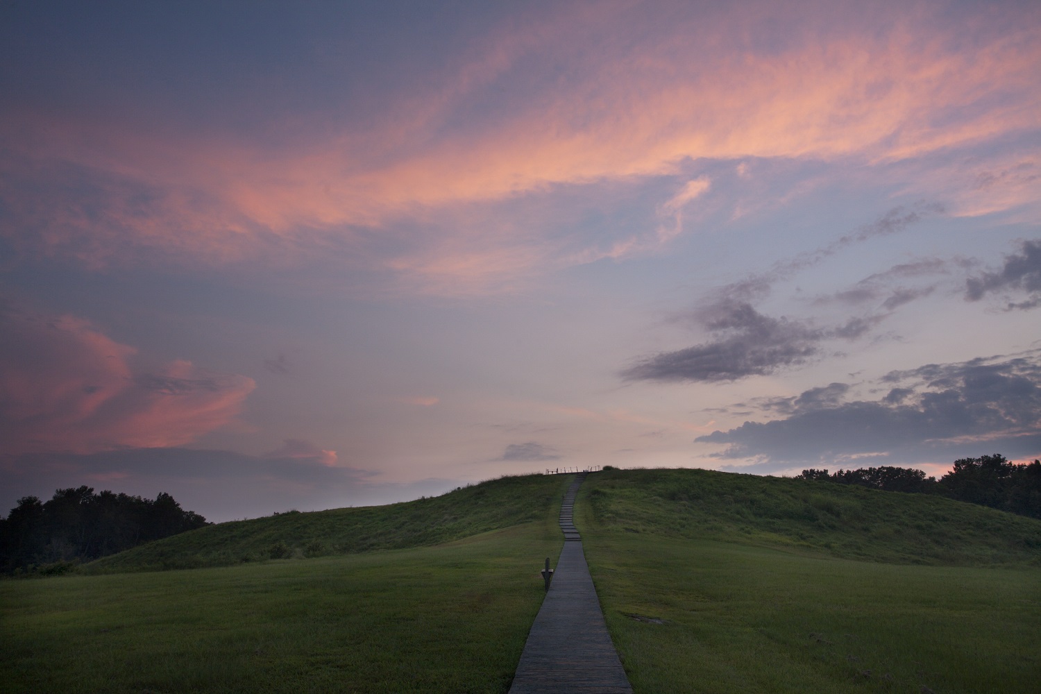
Photo by Jenny Ellerbe
Poverty Point’s Mound A at twilight.
Although the main themes of Poverty Point’s story were recorded in the 1950s, archaeological research since then has added considerable detail to that framework. Initially, archaeologists focused on excavating in the earthworks to better understand their structure and age of construction. But over the past two decades, the approach to research at the site has changed. New methods and technologies provide different kinds of information in ways that also promote preservation. Applications of remote sensing methods, advances in dating, and various analytic techniques are giving rise to new ways of thinking about the site and presenting those ideas to the visiting public. Indeed, knowledge gained through these new approaches substantially strengthened Poverty Point’s 2013 nomination to the World Heritage List.
Whereas early maps of the site’s layout were traced from aerial photographs, using artistic license to draw in those areas hidden by trees, we now have aerial LiDAR (Light Detection and Ranging) and total station surveying instruments. These instruments use lasers to measure the landscape and allow us to produce precise, detailed topographic models of the site. The newer maps show subtle rises and ridges that reflect both greater complexity and less symmetry in the design of the earthworks than previously illustrated. These observations appear to counter the idea that the people who built the mounds had a grand plan from the outset to guide the construction.
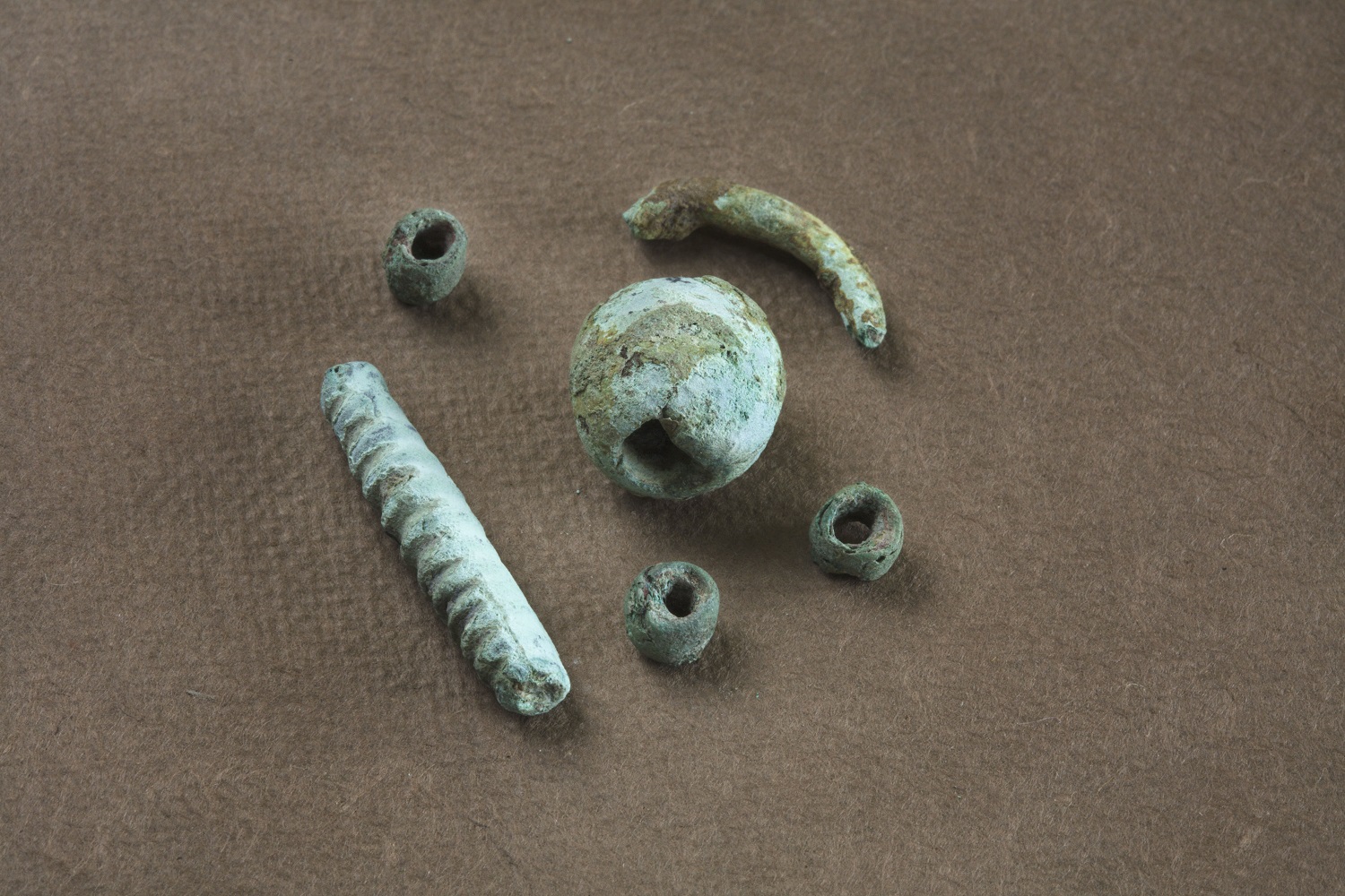
Copper artifacts from Poverty Point. Photo by Jenny Ellerbe.
Through geophysical survey, archaeologists can begin to answer questions about the landscape in ways that earlier researchers would not have dreamed possible. Geophysical instruments allow the nondestructive measurement of properties of the earth invisible to the eye. Instruments like magnetometers, resistivity meters, and ground penetrating radars have been around for years, but data collection and processing were time-consuming and early efforts did not provide the level of discrimination that researchers were expecting or hoping for. Improvements to their sensitivity, resolution, and capacity make them more useful for archaeological research than ever before. These instruments can now cover large areas very quickly, providing information about buried deposits without disturbing them. Whereas in many field seasons of excavation researchers had investigated less than 1 percent of the site area, much larger areas can be studied with minimal destruction by new technologies. Use of these instruments will not replace traditional archaeological methods like excavation or soil coring, but now archaeologists can target their efforts to obtain the data of interest with the least damage to the site.
Take, for example, the plaza. Encircled by the innermost of the C-shaped ridges, it measures about forty-three acres and is quite flat. In the past, archaeologists considered plazas to be “empty ground,” meaning they were thought to have been public spaces kept clean for social activities and so contained few artifacts and little evidence of construction. Earlier cores and limited excavations had revealed that the natural topsoil had been removed in some areas, either scraped away purposely or eroded naturally, and sometime after that people covered these areas with dirt (archaeologists call it “fill”). More focused coring, coupled with physical, geophysical, and chemical analyses of the soils, has shown this practice to be widespread within the plaza, with as much as three feet or more of fill added to raise and level the surface. Thus, even though it does not stand out like the surrounding mounds and ridges, the plaza is really a huge and quite complicated earthwork.
Recently, archaeologists used magnetic gradiometers to map the subsurface over much of the plaza at Poverty Point. Gradiometers measure very slight changes in the strength of the Earth’s magnetic field. At Poverty Point, this magnetic variation can result from heated features like hearths and earth ovens, from different soils used to build earthworks or fill pits, or from artifacts made of different materials. To learn more about the plaza, a magnetic susceptibility soil probe supplied complementary data. This method measures the ability of soil particles to be magnetized, which can tell archaeologists which soils were placed there by people and which are naturally occurring. Archaeologists and other specialists combined information from these two devices with geologic soil descriptions and chemical soil analyses to learn new information about the plaza.
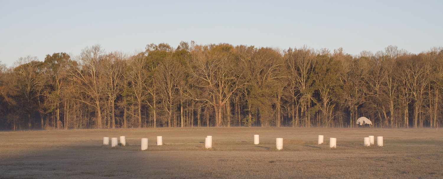
PVC cylinders have been placed to show the size and location of one of the timber circles in Poverty Point’s plaza. (The cylinders do not represent individual timber posts but simply provide an outline of the circle.) Photo by Jenny Ellerbe.
One of the most astounding discoveries during the geophysical survey, confirmed by cores and targeted excavations, was traces of more than thirty timber circles beneath the fill in the plaza. Imagine this large, flat, public space, with circles of large cypress posts. Applying a common rule of thumb for setting posts, with one third below ground and two thirds above ground, the posts would have stood somewhere between six-and-one-half to thirteen feet tall, arranged in circles of sixteen to two hundred feet in diameter. The posts were not left to rot in place, but rather they were pulled up, the holes refilled with dirt, and new holes dug to place more posts, often in the same area. We do not yet know what the purpose of the timber circles was, but our radiocarbon dates show their construction spanned much of the site’s occupation. Their construction and deconstruction represent a significant amount of effort. Even though they are buried by fill and completely invisible at the ground surface today, the timber circles were clearly a central and visible part of life at Poverty Point.
Although radiocarbon dating has been used to estimate the age of Poverty Point for many years, changes in technology allow more precise dates on much smaller samples. Instead of scraping together a handful of charred wood, which could come from multiple trees and represent growth over many years, archaeologists now can submit individual seeds, fragments of nutshells, or twiggy bits, which are formed in a single year, for dating. Optically stimulated luminescence is another dating technique used at Poverty Point. It can determine the last time sediments were exposed to sunlight or when an object was last heated. Contexts where there was previously not enough charred botanical material to obtain a secure date can now be dated.
Archaeologists now have a better estimate for the overall timeframe of the site’s occupation than before, as well as a construction sequence for the different earthworks. Given the information we have thus far, of the six mounds, Mound B seems to be the oldest, followed by Mound E, with Mound A and some of the concentric ridge segments next; Mound F is the last construction attributed to the Poverty Point culture. Although clearly Poverty Point constructions, it is not yet certain where Mound C, other ridge segments, and the plaza belong in the sequence. Mound D was added to the complex by another culture about 1,800 years after Poverty Point’s main occupation ended.
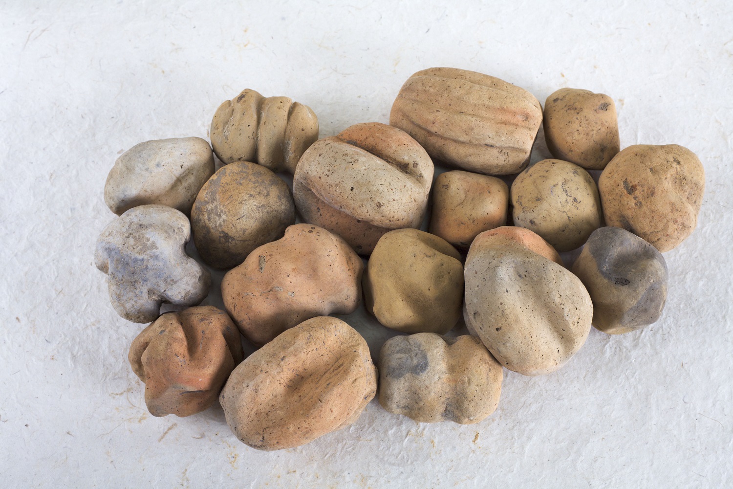
Fired earth “cooking balls,” also known as Poverty Point Objects. Photo by Jenny Ellerbe.
In addition to more refined dating, by studying the microscopic characteristics of the accumulated soil, archaeologists can assess how quickly the earthworks were built or whether buried layers within them were specially prepared surfaces or floors. Whereas it was originally thought that building the earthworks was a long-term process, taking several generations, it appears that when some components were built, they were built much more rapidly, perhaps taking only a few months or even weeks.
The application of new technologies is not confined to the study of Poverty Point’s cultural landscape. Archaeologists are learning more about the artifacts, as well. There is no naturally occurring stone at Poverty Point. Every rock found there was brought in by people. Indeed, it has been estimated that more than seventy tons of rocks and minerals were brought to Poverty Point from locations in eastern North America. Non- and minimally-destructive techniques for analyzing different materials, so-called “chemical fingerprinting” methods, are used to compare the composition of artifacts to the composition of geological samples collected for that purpose.
For example, archaeologists once thought that the copper for beads, needles, and other items found at Poverty Point most likely came from the large native copper deposits of the Great Lakes area. Recently, some copper artifacts were studied using a laser ablation inductively coupled plasma mass spectrometer (LA-ICP-MS). This instrument uses a focused laser beam to knock off a tiny bit of material from a spot much smaller than the size of a pinhead, vaporizes it, and measures the amounts of different elements contained within it. This research showed that at least some of the copper came from sources farther east, most likely from the southern Appalachians. That is where other Poverty Point materials, including soapstone bowls, came from as well. Given the success of this approach to geological source identification, more copper artifacts are being analyzed to see if any of the copper came from the Great Lakes area.
Analyses like these are helping archaeologists to know where these materials came from, and where they did not. Knowing that these materials were imported, and from what location, and in what condition they arrived is critical for understanding how they got to the site. Did the people of Poverty Point go to the sources to get the rocks and minerals themselves, did they trade for them, or did visitors from afar bring them? That is still an open question.
These are just a few of the ways that archaeological research is changing at Poverty Point. By emphasizing the application of non- and minimally-destructive technologies, archaeologists can answer many important questions about this exceptional, vanished cultural tradition while preserving the site for future generations to study and enjoy.
Diana M. Greenlee is the station archaeologist at the Poverty Point World Heritage Site and an adjunct professor of archaeology in the School of Sciences at the University of Louisiana at Monroe. She, with photographer Jenny Ellerbe, coauthored Poverty Point: Revealing the Forgotten City, which was recognized as a 2016 Humanities Book of the Year by the Louisiana Endowment for the Humanities. In her spare time, Diana is a firefighter with the Goodwill Volunteer Fire Department. She can be reached at [email protected].
