Of Basins and Watersheds
An alternative view of Louisiana’s geographical context
Published: November 30, 2023
Last Updated: February 29, 2024
Map by Richard Campanella
Beholding the Mississippi Basin is one way to understand Louisiana’s place in continental geography, and it’s pretty impressive. Few other places, particularly one so flat and subtropical, can claim alluvial contributions from places like Montana’s frigid Bitterroots, the dry plains of Texas, Minnesota’s tallgrass prairie, Kentucky’s bluegrass country, and Tennessee’s lush Appalachians.
Yet not all of Louisiana is hydrologically within the Mississippi Basin, nor drains directly into the Mississippi. The parishes of the southwestern prairie are in the Calcasieu/Mermentau Basin; those in southcentral Louisiana flow out the Atchafalaya and Vermilion Rivers; and those on the deltaic plain in southeastern Louisiana actually flow away from the Mississippi River, even as they abut or straddle it. If you stand on the French Quarter levee in the rain, the waters in the river in front of you derive from throughout the North American interior, but the water falling on you will flow backwards, into brackish Lake Pontchartrain.
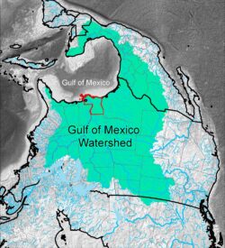
Another way to perceive Louisiana’s place in North America—one that includes all of our state—is to view it as part of not only the Mississippi Basin but also the Gulf of Mexico Watershed. (Note: I am using the word “watershed” here to avoid confusion with the salty waterbody of the Gulf of Mexico itself, which is the more common use of the term “Gulf of Mexico Basin.”) That is, imagine all the lands that shed water that eventually flows into the Gulf of Mexico, be they from Canada, the United States, Mexico, and arguably even Cuba.
It’s a perception that is surprisingly rare in the spatial psychology of Louisianans. Indeed, the map of the Gulf of Mexico Watershed may be new to many readers; I myself had to make the one shown here, using US Geological Survey hydrological data intended for other purposes. I oriented it with South pointing up, befitting the notion of the Gulf as our central organizing feature. The map may look strange to our eyes, but it makes perfect sense from a hydrological perspective.
Perhaps for reasons of history or nationhood, we tend to look upriver to contextualize our state—into the hinterland, the American interior. But our foreland—that is, the maritime world beyond, with which Louisiana has long interacted like few other states—also gives us context and meaning. The same Gulf tides that wash coastal Cameron and Plaquemines Parishes also intermix with those flowing off the flanks of the third-highest mountain in North America, Pico de Orizaba, located just seven hundred miles from Louisiana on the Mexican Gulf Coast.
What does the Gulf of Mexico Watershed look like? Whereas the Mississippi Basin resembles a funnel, this larger watershed is shaped a bit like a grabbing hand, with the wrist extending all the way to the Canadian Rockies, the knuckles going up the Ohio River, the fingers forming the Florida Peninsula, the thumb looping around Mexico and the Yucatán Peninsula, and Louisiana right smack in the palm.
It spans from the 15o latitude in the tropical zone to 51o latitude in the northern temperate zone, and rises from –12 feet (below sea level) in the Eastover neighborhood of New Orleans, to 14,270 feet at Grays Peak in Colorado, to 18,491 feet at Orizaba in Mexico.
The watershed’s perimeters are separated by roughly 2,000 miles, be they mountain ridges or coastal bights, and its total land area measures 2,101,916 square miles, close to double that of the Mississippi Basin. It drains some or all of thirty-four US states, two Canadian provinces, and fully twenty-six of the thirty-two Mexican states.
Just like for the Mississippi Basin, the Mississippi River is by far the largest waterway in the Gulf of Mexico Watershed, having the greatest water volume and sediment load, longest channel, and broadest network of tributaries. This puts Louisiana front and center in both spatial constructs—the Mississippi Basin and the Gulf of Mexico Watershed—highlighting its keystone position in economic, cultural, and physical geography.
If you stand on the French Quarter levee in the rain, the waters in the river in front of you derive from throughout the North American interior, but the water falling on you will flow backwards, into brackish Lake Pontchartrain.
That’s what I find informative about this perspective: it inclusively captures Louisiana’s interactions with Gulf and Caribbean communities, as well as those in our hinterland, in centuries past and today. To wit, coastal Louisiana once abounded in vessels large and small, coming and going daily to Biloxi, Mobile, Pensacola, Tampa, and Galveston, and all these places are hydrologically unified on our map. The port at New Orleans once interacted weekly with the Mexican ports of Tampico and Veracruz, and the Cabildo in Mérida looks much like the one on Jackson Square. All this resonates spatially when we see how these places plot out on the Gulf littoral.
Louisiana today relies economically on the international maritime trade, on estuarine fisheries, and on petroleum extracted from deep-Gulf wells and processed within our borders; all this too is readily apparent on our map. Likewise, in the past and perhaps again in the future, Louisiana has had intimate economic and cultural relations with Cuba, which of course also sits astride the Gulf. While the cartographic data I analyzed happened to put Cuba entirely within the Caribbean watershed (it’s somewhat arbitrary where one draws the Gulf of Mexico–Caribbean Sea boundary), with a little thalassic license, one can reasonably view Havana as Gulf-facing and therefore Gulf-draining. So you’re free to imagine half of Cuba as colored green on our map.
The resonance of viewing Louisiana as integral to both the Mississippi Basin and the larger Gulf of Mexico Watershed may explain the rising popularity of the term “Gulf South” to describe our region. Unlike other monikers, such as the “Lower South” or “Southwest” (used in the 1800s), the “Deep South” (mid-1900s), or simply “the South,” all of which only look inland for regional context, “Gulf South” pays homage to the roles of both foreland and hinterland in inscribing character into place. And that’s exactly what I see in the Louisiana-embracing map of the Gulf of Mexico Watershed.
Richard Campanella, a geographer with the Tulane School of Architecture, is the author of Draining New Orleans, The West Bank of Greater New Orleans, Bienville’s Dilemma, and other books. He may be reached at richcampanella.com, [email protected], or @nolacampanella on Twitter.