Geographer's Space
“Neutral Ground”
Neutral ground, the New Orleans toponym used for street medians, is a phrase that originated in a territorial dispute in western Louisiana.
Published: September 3, 2015
Last Updated: March 11, 2023
Courtesy of the Library of Congress
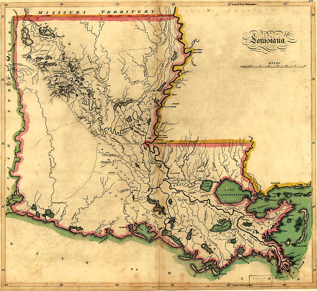
The conspicuously empty space in the southwestern corner of Mathew Carey's 1814 map of Louisiana marks the "Neutral Ground" agreed upon between Spain and the U.S. during 1806-1821. The term later found its way into the urban idiom of New Orleans.
I do not question this explanation; it is reasonably accurate. But there are opportunities to flesh out the provenance and chronology of this unique local idiom.
“Neutral ground” as a proper noun and a toponym (place name) entered the Louisiana lexicon in 1806, a year before Canal Street was created, courtesy of a military resolution to a lingering imperial disagreement over present-day southwestern Louisiana. Spanish colonials in Mexico had viewed the land roughly between the Sabine and Calcasieu rivers as the easternmost frontier of New Spain, while French authorities in the Mississippi Valley saw it as the westernmost reaches of their Louisiana.
Neither colonial power made too much of this irresolution; there was no gold or silver at stake and both governments put their priorities elsewhere. But they did keep an eye on each other. When the French established Natchitoches near the Red River in 1714, for example, the Spanish responded a few years later by pointedly erecting a fort just to the west. For decades to come, this region, known as Los Adaes, formed an unusual cultural interstice where isolated Spanish, French, African and indigenous peoples interacted in a power vacuum, a space without a hegemon.
The inter-imperial tension became moot when, in 1762, France, foreseeing defeat in the French and Indian War, ceded Louisiana to the Spanish to keep it out of the hands of the English. Now Natchitoches and Los Adaes answered to the same king.
Fast forward four decades and the boundary problem returned.
The Spanish by this time had retroceded Louisiana (1800) to the French, who sold it three years later to the United States. But because the disputed region had never really been officially resolved, ownership of the “Sabine strip” remained unclear. Now it was the Spanish and the Americans who stared each other down over piney woods and prairie.
Enter at this point Spanish Lieutenant Colonel Simon de Herrera and American General James Wilkinson, who, in 1806, hammered out an agreement in which neither would send forces into the area between the Sabine River and Arroyo Hondo, the Spanish name for the Calcasieu River. They called this area “Neutral Ground,” and despite its inexactitude, the accord succeeded in keeping the peace. Wrote historian J. Villasana Haggard in 1945, “the Neutral Ground was recognized as a well-known area lying between two sovereign nations but under the authority of neither….”
“Neutral Ground” thus entered the Louisiana discourse as a proper noun, capitalized and officially defined. It affected the state’s boundaries when Louisiana joined the Union in 1812 and when, in 1819, Spain agreed to relinquish the Neutral Ground to the U.S., thus creating our current Texas/Louisiana border. The term appeared in territorial and state papers during the 1810s-1820s, and presumably it circulated in conversations in and around the state capital of New Orleans. Even after its administrative resolution, the former Neutral Ground made news as a lawless region with more than its share of rogues and ruffians. Some called it the Sabine Free State.
While “Neutral Ground” as an official political geography disappeared from the Louisiana map, “neutral ground” nonetheless continued to resonate as a term and a concept. It seems to have particularly reverberated with anglophones in postcolonial Louisiana: these were, after all, English words in a francophone society, and newly arrived Anglo-Americans constantly found themselves living between and amongst rival factions they did not understand, but with whom they had to coexist. The expression formed a useful trope for negotiating the contested spaces in Creole New Orleans through the oftentimes-painful process of syncretizing with American culture. The moniker’s mildly sardonic hyperbole—it’s not like Creoles and Americans were actually preparing for violent conflict, although sometimes it felt that way—imparted a jaunty, in-the-know tone which made the term all the more appealing.
In 1836, when Creole-American ethnic rivalry came to a head, authorities reached into the tool bag of political geography for a solution: by re-drawing jurisdictional lines to subdivide New Orleans into three semi-autonomous municipalities, each with its own council, police, services, schools and port, united under one mayor and a general council.
The drawing of municipality lines entailed an overlaying of ethnic geography upon urban geography. The Creole-dominated French Quarter and Faubourg Tremé would become the First Municipality, and would be divided from the poorer Creole and immigrant lower faubourgs (Third Municipality) by prominent Esplanade Avenue. Heading upriver, the First Municipality would be separated from the Anglo-dominated Second Municipality by 171-foot-wide Canal Street.
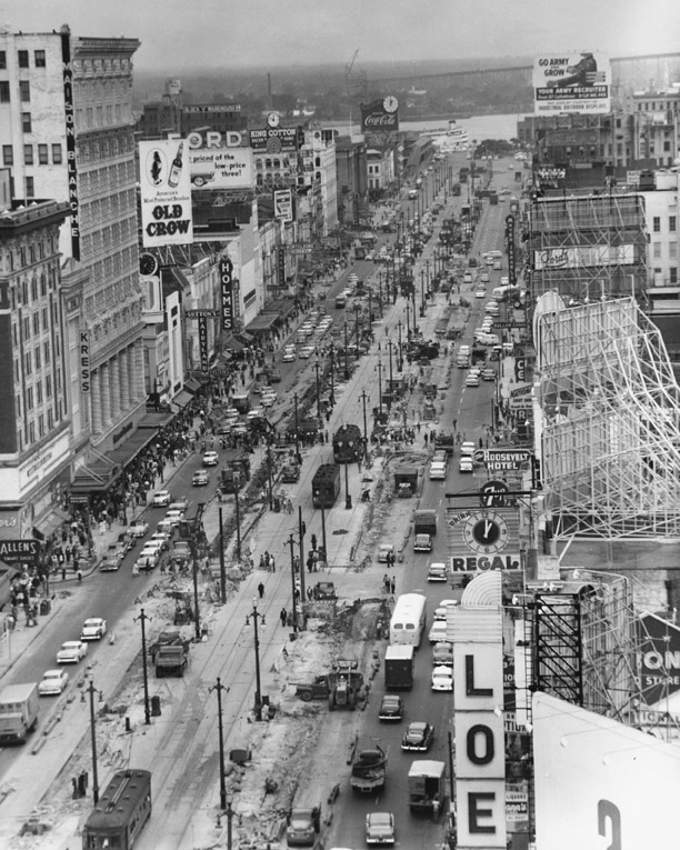
The “neutral ground” on Canal Street, photographed here in the 1950s, was once a division between the downtown Creole neighborhoods and the uptown American sector. Courtesy of the Louisiana Division/City Archives, New Orleans Public Library
A system designed to ameliorate intra-urban antagonism, however, ended up only reifying it. Municipalities competed for scarce resources, and costly municipal services all had to be in triplicate. Most of the rivalry played out between the densely populated First (mostly Creole) and Second (mostly Anglo) municipalities, on either side of Canal Street and its spacious median.
One rainy morning in January 1837, a new newspaper hit the streets of New Orleans. It was named The Picayune, and it was published in English by Anglo-Americans from an office on the Anglo side of Canal Street. Apparently those rains continued all winter, rendering Canal Street one muddy mess—enough for The Picayune to gripe about the problem repeatedly. On March 11, 1837, it wrote, “ ‘The Neutral Ground’ — This fair portion of our beautiful city is becoming daily … an object of deep interest. A large number of emigrants from the neighborhood marshes have settled on this territory. We suppose they intend laying it off into lots, and giving it the name of Frog Town…. Canal street — it is to be called by the above name in the future.”
This is among the first clear published uses of “neutral ground” to refer to Canal Street’s median, and while a direct link to the circa-1806 usage might be difficult to make, it stands to reason that locals would reach into their local vocabulary and, with tongue in cheek and a fair dose of irony, pull out a familiar term which accommodated a comparable local situation. Note that the anonymous writer put the term in quotation marks, implying it was familiar enough to go unexplained, yet new enough to warrant conscientious punctuation.
Similar uses appeared throughout 1837 and 1838, usually under the same dateline of “The Neutral Ground.” A May 21, 1839 editorial mentioned the municipalities it separated: “The ‘Neutral Ground.’ — We intend giving the First and Second Municipalities…a regular dose [regarding] the abuses in Canal street….” Stated an April 21, 1840 article in the same vein, “the boundary war and the improvement of the neutral ground in Canal street occupy a large space in the public mind…” This time, the term appeared without quotation marks, which by the 1850s became standard.
(Why was Canal’s neutral ground such a mess? Possibly because two adversarial municipalities shared jurisdiction of it, which would have shifted responsibility to the general council — the very governing body rendered ineffective by the inane municipality system. It was finally abandoned in 1852.)
“Neutral ground” by the late antebellum age was widely used to describe Canal Street’s median, and soon began to spread to other arteries. “The alley which runs between the St. Louis Cathedral and the old Court House buildings may be regarded as neutral ground,” joked the Picayune in 1852, “where saints and sinners may assemble without injury to the character of either.” A nostalgic 1864 Picayune article written during the federal occupation described “the centre grass plat [of] Esplanade street” as the “neutral ground” between the old First and Third municipalities. An 1865 article in the same paper cited a lawsuit on the “right to locate a fruit stand on the neutral ground of Poydras street.” The New Orleans Times, 1867: “through the neutral ground of Claiborne…” The Picayune, 1870: “the neutral ground of St. Charles…;” 1875: “neutral ground of Rampart…;” 1892: “the neutral ground of Carrollton,” and so on.
Long after the original Neutral Ground in the Franco-Spanish-American frontier disappeared from the Louisiana map, and long after New Orleans’ municipality system ended and its Creole/Anglo rivalry gave way to hybridization, “neutral ground” persisted in the New Orleans vernacular. It’s as strong as ever today, and unlike some other local shibboleths, such as banquette, red gravy, and making groceries, this one is spoken daily, without self-awareness, by just about every New Orleanian — and by no one else in the nation.
Except, that is, for residents of rural southwestern Louisiana, who commemorate the unusual heritage of what some call the “neutral strip” with the Sabine Free State Festival held each November in Florien.
—–
Richard Campanella, a geographer with the Tulane School of Architecture, is the author of Bienville’s Dilemma, Lincoln in New Orleans, Geographies of New Orleans, and most recently, Bourbon Street: A History (LSU Press, 2014). He may be reached through richcampanella.com or [email protected]; and followed on Twitter at @nolacampanella.
