Geographer's Space
Top of the Hill
Louisiana is the third lowest, third flattest state–and, topographically, among the most fascinating
Published: June 1, 2016
Last Updated: September 2, 2022
Courtesy of Wikipedia, photo by Billy Hathorn
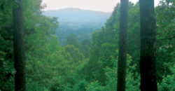
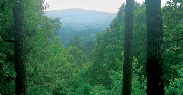
Mount Driskill
Yet despite its subtlety, topographic elevation has been extraordinarily consequential in Louisiana’s human geography because of its effects on soil fertility and habitability. More simply put, anything weak in supply but strong in demand has great value. Our state is, after all, largely alluvial and deltaic in its physical geography, a product of sediment-laden water transported by gravity and guided by topography. Thus it is of interest to put some numbers on our gentle terrain and see how it compares nationwide.
In terms of elevation — that is, the vertical distance above or below mean sea level — Louisiana’s lowest spots fall entirely within metro New Orleans. Drainage of the backswamp and encirclement by manmade levees have caused roughly half of the metropolis, namely those areas farthest from the Mississippi River, to drop below the level of the sea, a circumstance unique in the region. The contiguous urbanized portions of Orleans, Jefferson, St. Bernard, and Plaquemines parishes thus rank as Louisiana’s and the South’s lowest terrain, with an average elevation of 0.5 feet below sea level. The lowest human-inhabited area within that bowl is the Eastover neighborhood in eastern New Orleans, of which roughly half is 10 to 14 feet below sea level. Parts of Lakeview and Gentilly are not much higher, at -6 to -8 feet, while certain canal beds throughout the metropolis are (when dry) 18 to 20 feet below sea level.
Two hundred miles to the northwest, in rural Bienville Parish, lay the quartz sands of the Cockfield Formation, a series of pine-covered hills peaking at Louisiana’s summit, 535-foot-high Mount Driskill. That high point measures one-tenth of a vertical mile above the state’s lowest point in eastern New Orleans. In contrast, elevational range of California, whose apex (14,505-foot-high Mt. Whitney) and nadir (Death Valley, -282 feet) extends 2.8 vertical miles. Alaska, meanwhile, rises 3.85 vertical miles from the sea to the summit of Denali, which also happens to have the world’s highest base-to-peak elevation. In Mount Driskill, Louisiana has the third-lowest state high point in the nation, after Delaware (450 feet) and Florida (345 feet). It’s also one of the few states whose tallest building (New Orleans’ One Shell Square, at 697 feet) towers over its natural zenith.
In Mount Driskill, Louisiana has the third-lowest state high point in the nation, after Delaware and Florida. It’s also one of the few states whose tallest building (New Orleans’ One Shell Square) towers over its natural zenith.
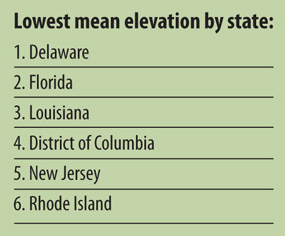
As it happens, Louisiana also has the third-lowest mean elevation of American states: 98 feet above sea level on average, a third more than Florida’s 63-foot average and over double Delaware’s 44-foot mean. (Interestingly, Alaska is nowhere near the nation’s highest state, despite Denali; every one of our Western states is substantially higher on average, with Colorado the highest, 6855 feet. That’s 70 Louisianas stacked on top of each other. Picture that.)
Elevation is but one metric of terrain. To capture more robustly the lay and shape of the land, the notion of topography is better suited. The word “topography” once had a broader and more literal meaning, implying the description (-graphy) of place (topo-). Usages in the 19th century, such as in John Howard Hinton’s The History and Topography of the United States of North America (1846), roughly matched how we currently use the word “geography,” touching upon everything from geology and flora to demographics and local history. What altered topography’s meaning was the inclusion of elevation contours on previously planimetric maps produced by the U.S. Army Corps of Topographical Engineers and (later) the U.S. Geological Survey (USGS). Because elevation contours were the most salient features on these popular new “topographic maps,” Americans began to associate “topography” with the shape and height of land surfaces — what technically is called hypsography (“description of height”). This was not necessarily the case in other Anglophone countries, where “topography” tends to retain its original meaning.
Today, in American English, topography now implies the lay, shape and form of land features as measured by elevation but also by slope, aspect, curvature, and their effect on water flow (hydrology). Of these metrics, slope—that is, the degree that a landform rises vertically for every distance it runs horizontally—best captures a landscape’s overall ruggedness (or flatness). A 90-degree slope is a sheer cliff; a 45-degree slope rises as high as it runs laterally; and a zero-degree slope is a flat plane.
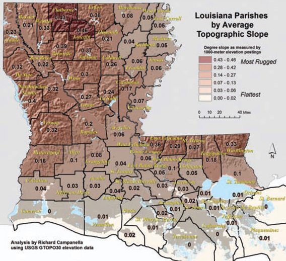
How does Louisiana stack up in terms of slope? To calculate this and other measurements for this column, I acquired USGS GTOPO30 digital elevation models, which plot global elevations for every 1000×1000-meter cell (pixel). I then computed the slope for each pixel and averaged the results by state and by each of Louisiana’s 64 parishes.
Just as Louisiana has the third-lowest state summit as well as average elevation, it also turns out to be the third flattest state, with an average slope of only 0.152 degrees: that is, climbing one vertical foot for every 373 horizontal feet traversed. In rural terms, that’s roughly the equivalent of walking up a single river levee during a one-mile walk; in urban terms, it’s like stepping up on a curb once per city block. Pretty darn flat, but not the flattest. Once again, Florida (0.115 degrees) and Delaware have us beat, with the First State gauging a nearly pancake-flat 0.103-degree average slope.
There’s a wide numerical gap between these three average slopes and the next cohort of mostly Midwestern states, demonstrating that Delaware on the Atlantic Coast, Louisiana on the Gulf Coast, and Florida on both coasts together form the nation’s tide-washed littoral doormats.
 For the record, the most rugged state in the union is not in the Mountain West nor Alaska, but Hawaii—and for good reason. It has earned its title: small as that volcanic archipelago is, the Hawaiian Islands are rugged throughout. The same cannot be said of states like Colorado, Wyoming or Montana, where vast eastern prairies tamp down the average slopes of their rugged western halves.
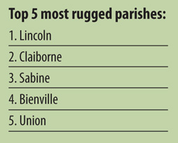
Within Louisiana, our most rugged parishes are Lincoln (0.46 degree average slope) and Claiborne (0.43 degrees — also our highest parish, averaging 267 feet above sea level), both of which are within 150 miles of Arkansas’ Ouachita Mountains. If all of Louisiana were as undulating as Lincoln Parish, we’d have the surface roughness of Nebraska. Still pretty darn flat.
 Yet despite Louisiana’s lack of topographic elevation — indeed, perhaps because of it — our slight undulations have proven highly consequential in the historical and cultural geography of our state. Just a few feet of elevation in deltaic New Orleans, for example, can spell the difference between a faubourg founded in the Napoleonic Age and a subdivision laid out in the Jazz Age — or Space Age. Just a few dozen feet separating the alluvial bottomlands of the Mississippi River and its tributaries from the abutting terraces and bluffs also distinguish 18th– and 19th-century plantation landscapes from adjacent 20th-century lumber-and-railroads areas. To a remarkable degree, maps of such diverse phenomenon as shotgun house distributions, French long lots, rice-and-crawfish intercropping, sugar cane cultivation, tree farming, and the state’s livestock industry all reflect underlying patterns of topographic elevation.
“The cultural landscape is fashioned from a natural landscape by a cultural group,” wrote geographer Carl O. Sauer. “Culture is the agent, the natural area is the medium, [and] the cultural landscape is the result.” Topographical elevation adds a third dimension to that medium, and paradoxically, Louisiana may the best place to evidence its importance.
—–
Richard Campanella, a geographer with the Tulane School of Architecture, is the author of “Bourbon Street: A History,” “Bienville’s Dilemma,” “Geographies of New Orleans,” and other books. He may be reached through richcampanella.com, [email protected], or @nolacampanella.