Geographer's Space
Beneath New Orleans, A Coastal Barrier Island
Unbeknownst to most of the 165,000 people who live above it, a sandy atoll exists beneath greater New Orleans
Published: December 1, 2016
Last Updated: October 30, 2018
Ever been to Ship Island off the coast of Mississippi, or nearby Cat, Deer and Horn islands? Dauphin Island near Mobile, Alabama, or our own Grand Isle in Jefferson Parish?
Unbeknownst to most of the 165,000 people who live above it, a similar sandy atoll exists beneath greater New Orleans. Were it not for this feature, southeastern Louisiana would look very different today, and its largest city likely would have been established elsewhere.
The subterranean peculiarity came to the attention of scientists as the result of a 1937 soil study conducted by a team of engineers and architects working with the Work Projects Administration. “It is a fine white sand,” wrote the researchers in an excerpt appearing in the New Orleans Item-Tribune, “mixed with sea shells of various kinds and sizes, at varying depths of one to fifteen feet below the surface.” Coastal geographer Roger T. Saucier called it the Pine Island Beach Trend, and it originally looked much like our present-day barrier islands except that its easternmost tip probably joined the mainland, south of Slidell, making it more like a peninsula, 30 to 40 miles long and one to two miles wide.
Pine Island formed around 4,500 years ago as the Pearl River, which separates southern Louisiana and Mississippi, deposited quartz sand into the Gulf of Mexico in an era of slowed sea-level rise. Longshore currents subsequently swept the shoal westward, sculpting it into an island—until a few centuries later, when a much larger river, the Mississippi, began depositing far greater quantities of sand, silt and clay particles from the opposite direction.
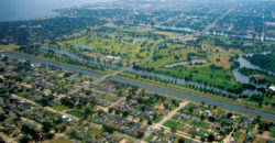
The Mississippi, for the prior 3,000 years, had been lunging about in what is now south central Louisiana, spreading alluvium over hundreds of square miles—“like a pianist playing with one hand,” as geographer John McPhee put it, “frequently and radically changing course, surging over the left or the right bank to go off in utterly new directions.” When that “hand” leapt eastward, however, it found itself blocked on the north by Pine Island, whose bulk effectively routed the river’s meandering channel on a continued eastward path. Wherever the river went, it deposited sediment and raised the delta’s elevation. For this reason, Metairie Road, City Park Avenue, Gentilly Boulevard and Old Gentilly Road/Chef Menteur Highway all follow a topographic ridge, even though the river has long since abandoned this channel for the present one. (The lagoons in lower City Park and Bayou Sauvage in eastern New Orleans are the last relics of this earlier course.)
The blockage created by Pine Island also had the effect of hemming in a bay and separating it from the rest of the Gulf of Mexico. Today we call this brackish tidal lagoon Lake Pontchartrain, and were it not for Pine Island, river-borne sediments likely would have converted much of its water body into marsh and swamp, just as they were doing to the south and east.
Such depositions gradually landlocked Pine Island, and its sandy beaches began to consolidate under constant overlays of river alluvium. No longer an atoll in the Gulf of Mexico, the old shoal was now a relic “trend”—the geological term for an elongated feature—lying anywhere from one to 30 feet below present-day Metairie, Lakeview, City Park and Gentilly, across New Orleans East and out to the Rigolets land bridge. That the former island is situated between the Metairie–Gentilly Ridge and the Lake Pontchartrain shore speaks to its role in guiding the formation of both features.
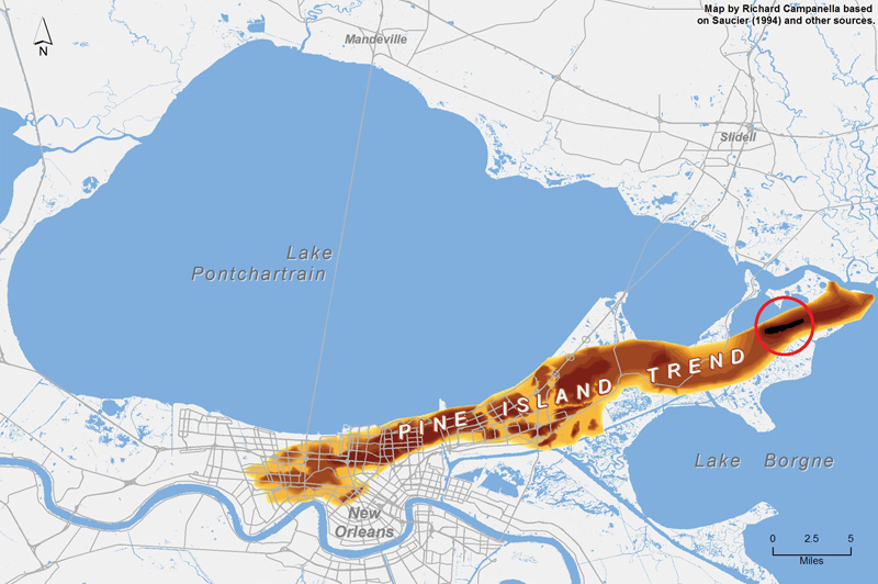
The subterranean Pine Island Trend in eastern Orleans Parish. The red circle shows location of surface expression. Map by Richard Campanella
Without Pine Island, southeastern Louisiana would have a radically different geography today, and we would have a very different history. Lacking the convenient back-door access that Lake Pontchartrain and Bayou St. John afforded to the banks of the Mississippi River, French colonizers probably would have gone elsewhere in seeking an ideal site for New Orleans. Eastern Lake Pontchartrain would look more like the Maurepas Basin; Slidell would have swamp rather than open water to its south and west; and the Mississippi may never have jumped into its current channel.
Humans have utilized Pine Island for centuries. From roughly 500 B.C. to A.D. 200, members of the Tchefuncte tribe built mounds of shells and bones atop the sandy atoll, either as ceremonial sites, encampments, hunting and fishing perches, or as middens (debris heaps). Now known as Little Oak and Big Oak Islands, these mounds rise up to 15 feet above the marshes of eastern New Orleans, and were used by natives, hunters, trappers and possibly maroons (escaped slaves) well into the 1800s.
The Pine Island Trend also figured into recent history. Residents of Gentilly got a rude awakening to its presence after Hurricane Katrina, when floodwaters gushing from the London Avenue Outfall Canal floodwall breach at Mirabeau Avenue excavated the ancient sands and piled them up like dunes among destroyed houses and cars, nearly covering some. Mollusk and clam shells, some as large as four inches across, lay strewn about, mystifying residents as they inspected their wrecked homes. Some speculated that the sand came in from the lake or gulf, but in fact it came from below. Tulane geologists Stephen Nelson and Suzanne Leclair characterized the resulting fluvial formations, which were cleared away in spring 2006, as “a rare but spectacular example of crevasse splay deposits in an urban environment.”
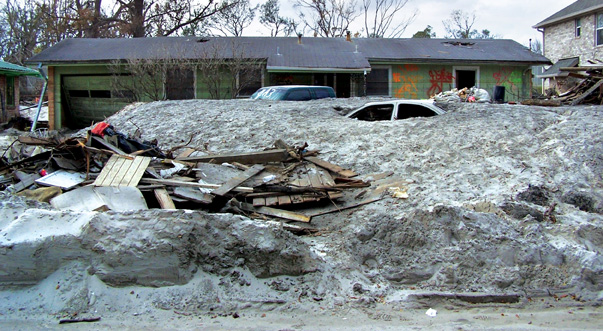
Pine Island Trend sand excavated by Katrina-induced floodwall breach in the London Avenue Outfall Canal, December 30, 2005. Photo by Stephen Nelson
In subsequent discussions of post-Katrina rebuilding, planners cited the Pine Island Trend as an opportunity for a compacted, sturdy geological foundation upon which major infrastructure could be footed. It also figured into arguments to save New Orleans East from “green spacing.”In the ongoing planning for improved urban water management, the architectural firm Waggonner & Ball envisioned a Gentilly Mirabeau Water Garden where “wetland terraces, rain gardens, bioswales, and a woodland wash [would] divert runoff[,] infiltrating it into the sandy substrate of the Pine Island Trend and filtering it for use in recreational and ecological features.”

Want to see the Pine Island Trend? There is only one spot where the feature emerges from its depths and breaks the surface, like the back of a swimming alligator. Next time you drive Highway 90 eastward toward Mississippi, look to the south into Lake Catherine as you climb over the Rigolets channel bridge by Fort Pike. You will see on the horizon the smattering of mature pine trees for which the feature was named. Pines are extremely unusual in a saline marsh of mucky organic matter and thin clay, and the only reason they grow here is because of another rarity here: sand. I visited this area by boat a few years ago and found artifacts all around—what appeared to be pottery shards, pipe stems and a human skull fragment—suggesting itinerant human occupancy much like Big Oak and Little Oak Islands, only without the shell mounds.
This remote spot is the only part of New Orleans’s natural land surface not created by the Mississippi River; it was created by the Pearl River. And when it first formed, it looked much as Dauphin Island, Ship Island and Grand Isle do today: white sandy beaches nudged ever westward by the longshore currents of the Gulf of Mexico, strewn with tall grass and scrub trees, windswept beneath a subtropical sun.
Richard Campanella, a geographer with the Tulane School of Architecture, is the author of “Bienville’s Dilemma,” “Geographies of New Orleans,” “Bourbon Street: A History,” “Lincoln in New Orleans” and other books. He may be reached through richcampanella.com, [email protected]; or @nolacampanella on Twitter.