Magazine
A New Beach for Louisiana
Caminada Headlands is the Coastal Master Plan’s largest completed restoration project
Published: May 31, 2018
Last Updated: February 27, 2019
Rush Jagoe
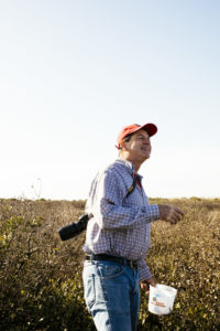
Dr. Gary LeFleur on Elmer's Island in Jefferson Parish.
“The waves were breaking right over there,” the biologist said, directing attention to a cluster of tall grasses located on the edge of the marsh, just beyond the beach. “There was nowhere to walk. When beach erosion is occurring, you get to a place where the waves are breaking there. It’s a sign that you really don’t have a beach anymore.”
LaFleur, an associate professor at Nicholls State University, had for the last decade been tracking coastal restoration efforts in Louisiana. As he stood on Elmer’s Island, he marveled at its new, man-made beach, a small part of the largest single ecosystem restoration the state Coastal Protection and Restoration Authority (CPRA) has ever undertaken.
The landscape before him, the result of a $216 million effort finished last year, was vastly different from the one he recalled during a visit to the island about twelve years ago.
More than a decade ago he had brought his daughters for a field trip to Elmer’s Island. He planned to let them admire the wilderness of a spot where the coast gradually transitions into the ocean without large swaths of development impeding the view.
But there were no rays of sun reflecting off miles of yellow-white sand. Instead, he discovered an ecosystem in peril, starved by coastal erosion happening so quickly that salt water had been allowed to surge in to a back marsh, killing off wetlands as it tore the beach barrier away from coastal communities it once protected.
Elmer’s Island had become victim to a widespread problem in coastal Louisiana. Land has been subsiding as sea levels rise. Erosion is happening faster in the Pelican State than anywhere else in the rest of the United States, in part because of a massive effort to reign in the Mississippi River.
Kneeling, LaFleur demonstrated by drawing lines in the sand. The river silt was the main building block that created Louisiana over thousands of years of flooding. As engineers channeled the waterway with levees to protect New Orleans, he showed, they began to starve surrounding marshland of sediment. LaFleur mimicked the formation of the state’s famous boot shape with his fingers, creating squiggles to the left, right, and center of its bottom half, then pointed to where the land began to sink over time.
The new beach covers an area equivalent to approximately 1,047 football fields.
That was in the 1930s. Since then, the oil and gas industry accelerated land loss after companies created channels in the wetlands to explore previously untapped reserves. Roughly ten thousand miles of canals were dug. The US Department of the Interior has attributed up to 59 percent of the state’s coastal land loss to this oil and gas industry development.
Hurricanes and other storms also took their toll, and the battered barrier islands began to disappear at a rate so alarming that scientists projected without restoration, they would be completely gone by the end of the century.
As the climate continues to warm, the local sea level is projected to rise more than 6.5 feet by 2100. Meteorologists say more frequent, intense storms will pound the coast, leaving locals exposed to even higher storm surges and devastating floods.
But now, there’s reason for hope. Experts point to the thirteen-mile stretch of new beach and dune running from the Belle Pass outlet of Bayou Lafourche eastward to Caminada Pass at the end of Elmer’s Island.
The project marked the first time engineers dredged sand from an ancient Mississippi River delta, Ship Shoal, out in the Gulf of Mexico below Cocodrie. Altogether, 8.4 million cubic yards of sand were barged thirty miles to the headland, where it was used to build up the beach 4.5 feet above sea level. Dunes were built to an elevation of seven feet, with a crest 290 feet wide.
The project reestablished nearly eight hundred acres of critical habitat for shorebirds and other wildlife and strengthened the first line of defense against the persistent effects of coastal erosion in Louisiana. The new beach covers an area equivalent to approximately 1,047 football fields.
“The results are outstanding,” Governor John Bel Edwards said after the state announced the project’s completion in March 2017. “CPRA’s restoration of this and other coastal beaches and headlands—along with the impressive rebuilding of our chain of barrier islands—sets the stage for even larger projects further inland as we restore our land and marshes that are vital to the protection of our homes, families, business, infrastructure and our very way of life.”
As of 2017, more than sixty total miles of barrier islands and berms had been constructed or were under construction as part of the Coastal Master Plan, a blueprint of sorts that prioritized land-building and preservation efforts as an increasingly uncertain future loomed ahead.
The latest iteration of the plan, approved by state legislature in June 2017, is a monumental undertaking, involving science never before performed on such a massive scale, being paid for with money that’s not yet fully secured. It’s the biggest restoration experiment of its kind in American history, involving an almost complete reengineering of the state’s bottom half.
Key aspects include slicing open Mississippi River levees to once again nourish starved wetlands with sediment-rich water, rebuilding entire barrier island systems, and constructing other protective infrastructure such as flood walls and levees. Together, the projects will cost at least $50 billion or more over the next fifty years, with some estimates pegging the projects’ cost at more than $100 billion in that time.
Like others, LaFleur had been skeptical of some of the Master Plan’s bigger projects. Some had been in the books for a decade. It seemed that Louisiana was moving at a snail’s pace on restoration and protection that should have been done years ago.
But now LaFleur and scientists with CPRA say that, because planners accomplished a project as massive as Caminada Headland, they have demonstrated that the momentum is there for the Master Plan’s other projects, slated together to build or restore eight hundred square miles of land.
“It makes me feel like we’re getting somewhere,” LaFleur said, pointing to the project description in his own hard copy of the 2017 Master Plan. “When it goes from wish list to done, that’s a beautiful thing.”
Darin Lee, a coastal resource scientist on the Caminada beach restoration project, agreed.
“We can sort of eat the elephant one bite at a time,” Lee said. “Now, we’re ultimately getting to the large-scale restoration we’ve envisioned all along.”
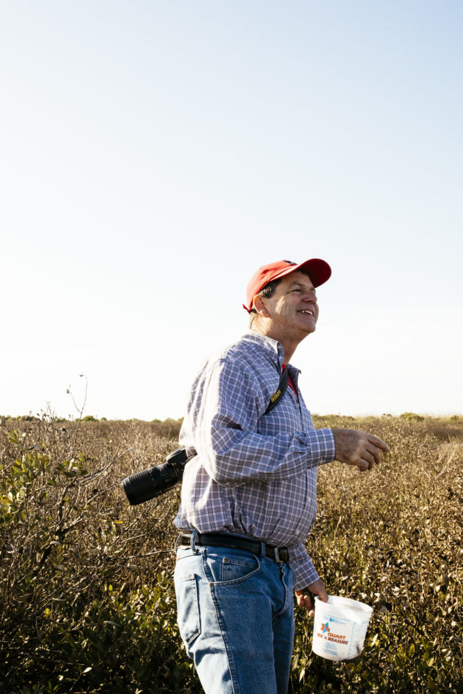
Now disappearing due to coastal erosion, the cemetery in Leevile was the final resting place of around fifty victims of the devastating 1893 hurricane. Photo by Rush Jagoe
Preserving culture
Large swaths of red bleed into southeast Louisiana’s coastal communities on a frequently cited United States Geological Survey animation showing land loss over time. Between 1932 and 2016, the state lost 2,006 square miles, roughly the size of Delaware.But no map is needed to understand how rapidly land is sinking in Lafourche Parish, where the Caminada Headland restoration project is located. That can be seen with the naked eye along the banks of Bayou Lafourche, which winds north to south alongside little Cajun towns like Larose, Golden Meadow, and Leeville.
Settled by French, Spanish, and German-speaking families in the early 1700s, the towns were a place where residents for hundreds of years enjoyed the bounty of the marsh’s lush wildlife, making lucrative livings off of fur trappings and shrimp. A century ago, rural communities stretched all the way from Golden Meadow to Leeville, where cotton fields and orange groves extended alongside large farmhouses.
Now, that way of life is threatened as Louisiana’s coastline recedes about a football field every hundred minutes. Large portions of Lafourche Parish have already washed away. Those farmlands have since become tiny wisps of marsh, clinging for life in open water. The once-distant Gulf of Mexico creeps in daily, widening the canals formed decades ago during drilling and dredging exploration.
“The inland marsh has taken a beating that’s pretty severe,” said Luke Adams, a marine patrol officer with Harbor Police who grew up in Larose, a census-designated place intersected by the Intracoastal Waterway.
Adams recalled a recent fishing trip with his father to a bay they used to frequent.
“My dad hadn’t come fishing with me for five or six years,” Adams continued. “I took him out and he said, ‘where’s the bay?’ The bay had become a lake.”
Land loss becomes more evident the further south one drives. Near Leeville, telephone poles sit in open water that’s encroached right up to the side of Highway 1. Crumbling crypts are all that’s seen of entire cemeteries literally falling into marsh off the side of the road.
In the distance, only leafless skeletons remain of trees that once flourished on cheniers, or raised ridges named after their stands of oaks. The prehistoric shorelines fanned out parallel to the modern Gulf shoreline as land naturally accumulated.
One such chenier, Cheniere Caminada, sits behind the new restoration project. Although only a few fishing camps remain now, it was long ago a booming village populated by settlers from France, Germany, and Asia. They lived off the land, drying shrimp on platforms and building sailing vessels to catch seafood that they ate and sold to New Orleans.
Their history has been documented by John Doucet, dean of the College of Arts and Sciences and professor of biology at Nicholls State University. He became an expert on the settlement after writing a play documenting the community’s demise.
The play, Tant Que Durera la Terre (As Long As the Earth Lasts), recalls an unnamed Category 4 hurricane that hit southeast Louisiana on October 1, 1893. It killed an estimated two thousand people, Doucet said, making it one of the deadliest storms in US history.
Interviews documented by journalist Rose C. Falls capture the voices of survivors from that hurricane in a book now on file at the Library of Congress. To a degree, they can be verified through old tax records. That’s how Doucet discovered the house belonging to his great-great-grandfather, a French-speaking oysterman raised as an orphan in Cheniere Caminada.
That ancestor, John Frederique Rebstock, was credited for saving sixty-two people under his large, triangular roof, which somehow remained intact after the base of his house imploded from the storm.
“They might have seen that roof while he was calling them in, or they might have been in the house already,” Doucet said of the survivors. Many weren’t so lucky.
Records show that 779 people died at Cheniere Caminada the night the hurricane landed, wiping out more than half of its estimated 1,500 in population. Some drowned in the sixteen-foot storm surge that pummeled the island from multiple fronts. Others, newspapers show, were crushed by collapsing homes as they sought shelter.
Ultimately, the community never came back. All that remains now are stories, told in part by a sunken, eroding cemetery marking about fifty of the dead. Doucet said there’s suspicion another mass grave exists at the lowest point of the burial ground, but it’s never been discovered.
Large portions of Lafourche Parish have already washed away. Those farmlands have since become tiny wisps of marsh, clinging for life in open water.
But looking forward, Doucet also said the lesson of what’s eroded so far—and landmarks, like cemeteries, that were unable to be saved—shouldn’t be lost upon the community.
“History is being lost, and that is terrifying,” Doucet said. “We’ve sacrificed our land to oil and gas exploration. To uproot a family and make them live somewhere else because we can’t stop natural disasters . . . it’s just unforgivable. And when I see a cemetery eroding into the Gulf, and we can’t save that—it’s also just unforgivable.”
The project provides protection for Port Fourchon, land base of Louisiana Offshore Oil Port (LOOP), which is connected to more than half of the oil refining capacity in the United States.
Looking forward
The restored Caminada Headland won’t just protect areas of cultural significance. It’s also designed to shelter a vital industry hub nestled among fishing communities south of Leeville, on a parcel of land below where Bayou Lafourche diverts to meet the Gulf of Mexico.Next to Grand Isle, a tiny resort island with beaches and coveted fishing spots, sits Port Fourchon. The industry hub services 90 percent of the nation’s deepwater oil and gas production.
It’s also the land base for the Louisiana Offshore Oil Port, which is the nation’s only deep-water oil port. It links refineries across the country and is connected to more than half of the oil-refining capacity in the United States. The port also services commercial fishing, seafood, shipping, tourism, and recreation industries.
The Caminada beach strip historically served as buffer between the Gulf’s waters and the port’s buildings and machinery but had become one of the most rapidly eroding pieces of shoreline along the Louisiana coast. In 2005, Hurricane Katrina destroyed much of the land, leaving the major economic engine exposed.
Now, Chett Chiasson, Executive Director of the Greater Lafourche Port Commission, says the renewed protection is already paying dividends for the port. In the works is an $800 million liquefied natural gas production and export facility. The project manager, Energy World USA, says the plant could produce up to five million tons of natural gas for export each year.
“Being able to tell current and prospective future tenants that the state and its partners have committed over a quarter of a billion dollars to environmental restoration that enhances our sustainability and security over the long term has been critical to us maintaining our market share through a downturn in the energy industry,” Chiasson said.
The Caminada Headland restoration project builds on beach barrier protection Port Fourchon has been undertaking on a much smaller scale for years. But for a long time, the state simply didn’t have the money to complement the port’s work.
Ironically, that changed after the 2010 Deepwater Horizon oil spill. Now, the bulk of funding for the Caminada project comes from the National Fish and Wildlife Foundation’s Gulf Environmental Benefit Fund, established in the wake of the disaster.
The fund manages monies resulting from the settlement of federal criminal charges against BP and Transocean. Of the pot, $145.9 million was set aside for the Caminada Headland project. The rest of the restoration project was funded by $30 million in state surplus funds and $40 million from the federal Coastal Impact Assistance Program.
On a recent field trip to the site, Joni Tuck, External Relations Manager of the Greater Lafourche Port Commission, pointed to a large tube of black fabric covering a mound of sand. The port had diverted sand and water slurry to the tube, where water leeched out of the fabric, creating a rock-hard barrier between the Gulf and the marsh. The port’s project was designed to prevent land loss in the same way beach restoration does—by blocking storm surge and preventing saltwater intrusion from damaging wildlife nearby. But it only protected a small part of the beach near the port’s operations, essentially leaving the rest of the headlands vulnerable to erosion.
That project now connects seamlessly to the more scenic Caminada Headland restoration. The new beach covers an area equivalent to about 1,047 football fields. In the distance, the Gulf’s landscape is peppered with oil platforms, wellheads, and other in-water structures. Roughly six hundred of them exist within a forty-mile radius of Port Fourchon.
“This is significant. This is huge,” Tuck said, pointing to the dunes stretching toward Grand Isle. “It’s a position we needed to be in, and that nobody thought was possible not that long ago. So you have to be positive about this.”
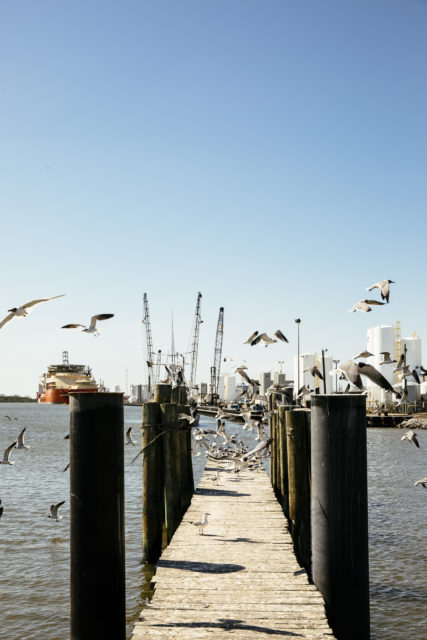
Erik Johnson, Director of Bird Conservation for Audubon Louisiana, is also excited. From a preservationist’s point of view, the restored Caminada Headland is critical. It’s considered one of the most important nesting areas in the state for a bird called least tern, and it provides habitat for other birds on the Endangered Species Act, such as piping plovers and red knots.
Johnson has been tracking the least terns that nest on Elmer’s Island since 2013. That year, there were a couple dozen pairs, he said. Last spring, after the project was finished, he estimated about five hundred pairs.
“Nowhere in Louisiana are barrier islands being formed naturally. They’ve all essentially been in a state of loss over time,” Johnson said, adding that restoration efforts are now mimicking the birds’ natural cycles, as they hop from rebuilt island to rebuilt island.
Experts, however, warn that the Caminada project isn’t done, at least not how it was first envisioned. The other part of the puzzle needed for healthy barrier islands and headlands is restoration of what’s called “back barrier marsh,” or the area located right behind the dunes.
That’s in the works now. If all goes as planned, the state will restore between 800 and 850 acres of marsh behind the Caminada beach by the end of 2020.
Back barrier marsh is critical because it not only helps slow storm surge but also recaptures the beach sand washed away by waves, according to Renee Bennett, CPRA’s project manager for the two projects. “These projects are great standalone projects, but they are even better when paired with the newly restored headland, which together prevent breaching of the headland,” Bennett said. “If we don’t build the marsh, all of that sediment will go into the bay, and be lost.”
As happy as LaFleur was to see the beach finished, he agreed. On a late March afternoon, he paused before offering his full assessment of the restoration efforts in front of him.
“You asked me to grade this,” LaFleur said, as he soaked in the tranquility of blue skies, soft sand, and a light breeze coming off the Gulf. He pointed in front of him. “This has a grade of A—getting the beach done,” he added. “But if this was a college class, I’d say you’d have to take an I, for ‘Incomplete,’ until you finish your marsh.”
Della Hasselle is a New Orleans–based reporter who covers environmental issues and Louisiana’s coast for The New Orleans Advocate and The Lens. She is also a frequent contributor to WWNO and The Hechinger Report and has been published in The Washington Post, Bloomberg, Al Jazeera America, and Huffington Post.