How Vallecillo Became Zwolle
Origins of Western Louisiana communities
Published: August 29, 2025
Last Updated: December 1, 2025
Richard Campanella
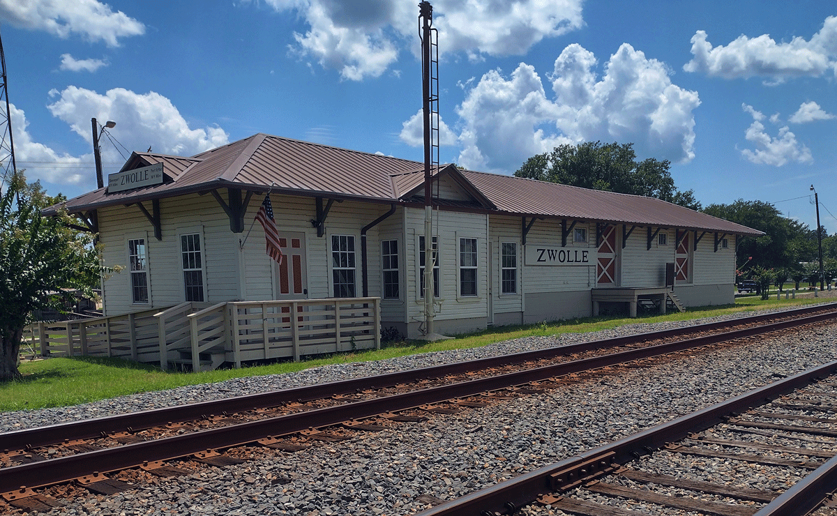
The train station in Zwolle, Louisiana.
 Editor’s note: Below is an edited excerpt from Richard Campanella’s latest book, Crossroads, Cutoffs, and Confluences: Origins of Louisiana Cities, Towns, and Villages (LSU Press, 2025), which investigates the original siting rationales of communities statewide.
In a state where most residents can trace their community locations to waterside sites settled in the 1700s and early 1800s, scores of settlements originated from railroads in the late 1800s and early 1900s. Chief among them was the Kansas City Southern Railway, whose trunk and spur lines spawned or repurposed thirty-one named communities throughout western Louisiana, from Caddo Parish down to Calcasieu Parish. About two-thirds were formed circa 1897 directly as a result of KCS stations or flag stops and survive today as small track-straddling population clusters[;] the other ten or so stations were created within pre-existing emergent settlements. Each benefited from the new economic lifeline, sometimes to the point of wholesale economic repurposing.
Mansfield, for example, had been founded in 1843 at the crossing of a backcountry road circumventing the Red River logjams to link Natchitoches with Caddo and Coushetta Indian villages, and another road heading west to Logan’s Ferry (now Logansport) across the Sabine River into Texas. Traveler J.W. Door described that artery in 1860 as a “ridge road” for stagecoaches, “rough and dusty in the extreme[,] running thus along the high lands.” It passed through the geographical center of the newly created DeSoto Parish, which is what got that crossroads designated a seat of justice and made into an administrative center. Named for a Scottish lord admired by a local official, Mansfield soon became a trade center, home to a women’s college, and the site of a key battle in the Red River Campaign of the Civil War. Mansfield’s economy changed radically once it attained a KCS station and became a junction for the Texas & Pacific Railroad. Lumber, cattle, and agricultural commerce bustled, as the population doubled to 1,800 people between 1900 and 1910, and again by 1930. Mansfield has since leveled off at around 5,000 residents, and the town still relies squarely on its dual siting rationales, as a centralized administrative crossroads which became a rail hub.
Leesville also began at a juncture of ridges, along a wilderness road heading west from Alexandria as it approached the Bayou Anacoco swamps. According to Vernon Parish historian John T. Cupid, the spot marked an area of unusually dark rich soil known as “the Blacklands,” good for farming and grazing. “This black soil surrounding Leesville, is largely responsible for the people settling around here.” By the 1860s, a doctor named Edmund Ellison Smart had operated a plantation on those fertile soils, including on a bluff above Bayou Castor where he had an office and general store. Its urban transformation became something of a family project, as Edmund’s father, John R. Smart, introduced a bill to the State Senate in 1871 to create Vernon Parish. He used his son’s donation of bluff-top land to host a courthouse, positioned near the center of the new parish to justify designating that spot as the parish seat. Edmund Smart named it Leesville, in honor of the recently deceased Confederate Gen. Robert E. Lee, while another family member, John F. Smart, won the contract to build the courthouse.
Like Mansfield, Leesville became an administrative and trade center, but without a navigable waterway, it struggled to develop—until the arrival of the KCS in 1897. The railroad made Leesville into a timber town, and helped get it selected for the Louisiana Maneuvers war exercises in 1941, and later for a permanent military base which later became Folk Polk. Were it not for the creation of Vernon Parish and Smart’s centrally located donation, there would be no Leesville, and if it weren’t for the KCS, there’d be no Fort Polk, Louisiana’s largest military base. Leesville today has a population of 5,400, while the “garrison town” of Fort Polk, renamed Fort Johnson in 2023, has upwards of twice that number of stationed troops.
Were it not for the creation of Vernon Parish and Smart’s centrally located donation, there would be no Leesville, and if it weren’t for the KCS, there’d be no Fort Polk, Louisiana’s largest military base.
Another hill-country settlement reactivated by the KCS is a marvel of Louisiana siting stories. It emerged along the dusty treads of El Camino Real de los Tejas, that network of wilderness roads extending from Mexico City to Los Adaes, the fortified Spanish mission (El Presidio de Nuestra Señora del Pilar) sited in 1717 to counter the French presence established at Natchitoches in 1714. In the same way the Camino crossing at Bayou Nana had given rise to the town of Many in Sabine Parish, so too did its crossing of a bayou confluence spawn another settlement ten miles to the north. According to one account, Spanish friars on their way to and from Los Adaes knew that confluence as Las Cabezas as early as 1767, and established a church in this vicinity, followed by a second one in 1795 named Nuestra Señora de Guadalupe, predecessor of today’s St. Joseph Catholic Church. Another account puts the founding at 1773, when, following the Spanish takeover of Louisiana, soldiers at Los Adaes who were ordered back to San Antonio instead settled at Las Cabezas, which they named Vallecillo (Little Valley) on account of the sloped terrain around the bayou confluence. Other Spanish soldiers settled four miles to the west at Ybarbo, named for Alcario Ybarbo, a relative of the founder of the mission at Los Adaes. In the century to come, Vallecillo and Ybarbo remained rural hamlets as this part of Spanish Mexico became the American state of Louisiana. All the while, Castilian Spanish gave way to American English, and Vallecillo got truncated to “Cie,” “Cye,” “Scie,” and “Bayou Scie,” while Ybarbo got anglicized to “Ebarb.”
Then came the KCS investors, among them a native of Zwolle, Holland named Jan DeGoeijen. As part of an inspection tour of Dutch financiers, DeGoeijen found charm in Bayou Scie’s hilltop St. Joseph Church, in the bonhomie in its people, and in their generosity for gifting ten acres for a train depot. Thus was born Zwolle—or rather reborn, from old Bayou Scie—and by 1913 it was “one of the important lumbering towns that has grown up along the line of the Kansas City Southern R. R.,” according to historian Alcée Fortier, writing in 1914: “It has a bank, a money-order post office and telegraph office, and is the trading and shipping point [extending to] the Sabine River.” DeGoeijen’s support of the old Spanish mission town continued until his death during the German occupation of World War II. Zwolle, Louisiana today is an incorporated town of 1,700 residents, while Ebarb is an unincorporated rural population cluster one-fifth the size. Why the difference? Because only Zwolle updated its raison d’être from mission to station and mill.
Among the other stops repurposed by the KCS are Rodessa, formerly Frog Level, originally founded in 1879 as a trading center; Mooringsport, established in 1836 as Timothy Mooring’s landing for ferries and steamboats on Ferry (now Caddo) Lake; and Westlake, which began in the 1840s as a timber town named Lisbon until economic activity shifted eastward and spawned Lake Charles. Taken together, these thirty-one western Louisiana communities created by KCS station sites are now home to nearly 150,000 Louisianians, half of whom live in neighborhoods outside downtown Shreveport and Bossier City. The average interval between those thirty-one station sites is 7.3 miles, with most falling in the 4-to-11-mile range—known in geography as “5-and-10-mile towns”….
As the KCS triggered settlements in the northern hill country, the Kansas City Watkins & Gulf Railway did the same to the northeast. Behind the project was Kansas-born Jabez B. Watkins, who in 1883 had purchased 1.5 million acres near Lake Charles and peopled them by recruiting Midwesterners to become Louisianians. In 1887, as president of the North American Land and Timber Company, Watkins obtained a charter for a railroad from Lake Charles through Arkansas and into Missouri, aiming to bring Gulf Coast lumber and cattle up to Kansas City. Advocates in Louisiana hoped the line would also do the reverse, such that “the products of Kansas and the great Northwest will find their way to the markets of the world,” wrote boosters in 1891, “[making] Lake Charles…one of the safest and most important seaports on the Gulf of Mexico.” Grading of the bed and laying of the so-called “Watkins Road” tracks began in 1890 and reached Alexandria in 1892, after which stations opened and settlements formed. The distances between them were mostly around five miles, some ten to fifteen, all in a straight line, and all with Midwestern-sounding names: Iowa (named for the state but pronounced EYE-uh-way), Woodlawn, Fenton, Edna, Kinder, Oberlin (named for the city in Ohio), Oakdale, Glenmora, Forest Hill, Woodworth, and the Willow Glen suburb of Alexandria. Most were founded wholly on account of KCW&G stations; about half became mill towns, and nearly all have since become highway crossroads.
In time, the KCW&G became known as the St. Louis, Iron Mountain & Southern line, and is now part of Union Pacific.
Richard Campanella, a geographer with the Tulane School of Architecture and Built Environment, is the author of sixteen books and hundreds of articles on Louisiana history, geography, architecture, and culture. He may be reached through richcampanella.com, [email protected]; or @nolacampanella on X.
