Hydrology at War
Bailey’s Dam at the Red River Rapids
Published: August 30, 2019
Last Updated: December 1, 2019
Institute of Museum and Library Services
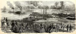
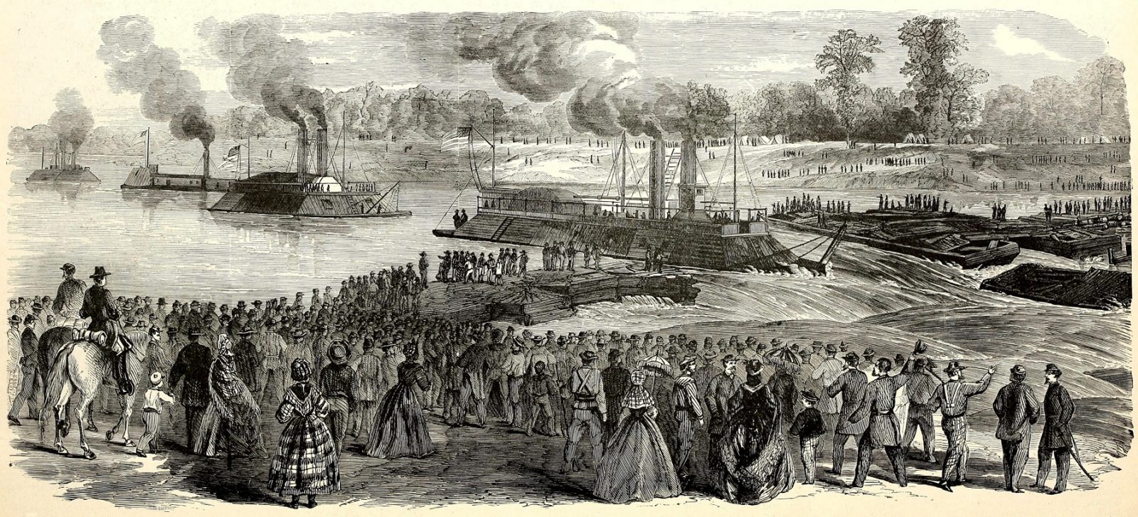
An engraving of Bailey’s Dam from Frank Leslie’s Scenes and Portraits of the Civil War, an 1894 collection of images of the conflict.
In some cases, hydrological manipulation has even been a tactic of war, and there’s no better example than Bailey’s Dam on the Red River at Alexandria.
Alexandria is in aptly named Rapides Parish, where navigators encountered a rarity in our region: rapids, traceable to the interface between the older, undulating siltstone and sandstone formations of the Kisatchie Wold, with the younger, flatter terraces to the south. This facies was incised by the Red River and filled with its alluvium, forming the Red River Valley. For centuries, an ever-shifting logjam known as the Red River Raft impeded flow and formed a series of natural reservoirs (“raft lakes”), from which some water managed to discharge in ever-changing volumes and channels. One channel uncovered a series of sandstone ledges in what is now central Louisiana, creating rocky outcroppings that increased water velocity and formed waterfalls up to six feet high.
When the river ran high, the rapids disappeared, but during low water, they presented a dangerous hazard to navigation. To get past them, French colonials had to either lighten their load or portage around the falls. All this took time, which led to the formation of a tiny settlement called Rapides starting in 1723. This would eventually become today’s Alexandria and Pineville.
In the 1830s, Captain Henry Shreve and the State of Louisiana cleared the Red River logjams, stabilized banks, and improved navigation among the Red, Atchafalaya, and Mississippi Rivers, allowing steamboats to reach Shreveport and beyond. But the rapids still frustrated traffic at Alexandria, forcing shippers during low stage to break bulk and portage around it.
When Southern states seceded from the Union in 1861, federal military planners aimed to suppress the rebellion by encircling the Confederacy as an anaconda grips its prey. Ports along the Atlantic and Gulf Coasts would be blockaded, and western rivers would be brought under control. This strategy made the Red River secondary in the beginning of the Civil War, as Union gunboats would first have to secure the Ohio River and win back the Mississippi.
Once this had been achieved in 1863, the Red River Valley came squarely into the theater of war. Reasons were threefold: the Red accessed the ample resources of Texas, which in turn abutted Mexico—a potential Southern ally—while the valley itself was said to hold ample stores of cotton, desperately needed for the Union cause.
Scuttling the fleet was an odious option, and surrendering it to the enemy unthinkable. There had to be another way.
With the goal of seizing Shreveport, the Union’s Red River Campaign began in early 1864, as the thirty-thousand-troop-strong Army and Navy struggled up from the Red’s confluence with the Mississippi. Confederate guerrillas bedeviled them, but the real problem was unusually low waters on the Red and their attendant sandbars and shoals. Worse yet were the rapids at Alexandria, where Rear Admiral David Porter struggled mightily to get only a portion of his thirteen gunboats and sixty supply vessels past the impedances. The rest of his Navy fleet was stuck at Alexandria.
The delay gave time for Confederate Major General Richard Taylor and his five thousand Texas cavalrymen to engage the Union Army, under the command of Major General Nathaniel Banks, in battles at Mansfield and Pleasant Hill. Confederate forces prevailed, and though Banks and his men managed to hold off a second assault, it became clear that the Army expedition was doomed without the support of the Navy, which was either stuck at the rapids or enduring relentless sniper fire.
Recognizing the whole campaign was at risk, the leadership abandoned the goal of taking Shreveport and instead aimed to withdraw to the federally controlled Mississippi River and live to fight another day. But by this time the Red had dropped even further, down to only 3.3 feet of depth, and the flotilla found itself trapped among the rapids and waterfalls at Alexandria.
Scuttling the fleet was an odious option, and surrendering it to the enemy unthinkable. There had to be another way.
Enter Joseph Bailey, a lumberman and self-trained engineer who had honed his skills on the Wisconsin frontier building mills, bridges, and dams. As a colonel, Bailey participated in General Grant’s unsuccessful 1863 attempt to circumvent Confederate artillery by digging a canal and routing the Mississippi around Vicksburg. Later that summer, he built dams to refloat grounded vessels at Port Hudson, the last Confederate stronghold on the Mississippi.
Now, on the Red River, Bailey assessed the situation and proposed a solution: construct a dam (or weir) to raise the water level and allow the boats to float over the obstacles.
Skepticism abounded, and some ridiculed Bailey’s idea. But Banks and Porter, desperate for reprieve, approved their subordinate’s plan and put three thousand troops, including emancipated slaves, under Bailey’s command.
Bailey’s strategy was to build the dam just above the lower rapids. This seemingly illogical positioning served two purposes: it would raise the water level behind the dam, which would allow the vessels stuck above the upper rapids to rise above the rocks and float downstream. Then, with all the trapped vessels now positioned behind the main dam, the blockage would be suddenly ruptured, and the high water pressure would propel the vessels over the lower rapids and safely downriver.
Starting on April 30, troops built the dam out from each bank across the 758-foot-wide channel. Because resources differed on each side, so too would the construction materials and technique. The Pineville (east side) had plenty of forest, which was cut into timbers, stacked up across the span, intertwined with branches and rope, and weighted down with rocks. The Alexandria side had more lumber, bricks, and scrap iron as well as rock, so rectangular cribs were built and filled with weighted materials. This left a gap in the middle, where four coal barges were moored to form a sort of gate.
It worked. The barricade allowed water levels to swell by three inches per day in early May. Some of the lighter vessels gingerly made their way over the upper rapids and joined the others at the main dam, to prepare for an orderly release over the lower falls.
But sheer physics threw order to the wind. On May 9, mounting water pressure dislodged the coal barges, and water started gushing out. Repair was out of the question, so Porter had little choice but to take advantage of the lift and race through the chute.
With thousands of spectators holding their breath, the vessels, one by one over the course of days, made their way across—some jostled, some spinning, and some with the help of three additional pressure-relieving “wing dams” built upriver. All passed safely.
By May 13, the ordeal was over. While Union forces had been defeated in the Red River Campaign—General William T. Sherman called it “one damn blunder from beginning to end”—at least they had not lost their fleet. Bailey won praise and promotion to brigadier general.
As for the Red River and the Louisiana cities thereupon, it was not until a century after Bailey’s wartime intervention that Congress, in 1968, passed the River and Harbors Act toward the construction of locks and dams for year-round navigability on the Red.
Yet all these years later, components of Bailey’s Dam are still in place, and during low water, they occasionally break the surface—a visible reminder of the one time when hydrological manipulation in Louisiana went to war.
Richard Campanella, a geographer with the Tulane School of Architecture, is the author of Cityscapes of New Orleans, Bienville’s Dilemma, Bourbon Street: A History, and other books. He may be reached at richcampanella.com, [email protected], or @nolacampanella on Twitter.