On That Word “Delta”
Fluid feature, fluid meaning
Published: February 28, 2021
Last Updated: June 8, 2021
US Army Corps of Topographical Engineers, Library of Congress
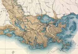
Detail, Map of the Alluvial Region of the Mississippi.
What do we mean when we say “delta?”
The noun is an ancient one, and its inferences span the realms of language, math, and geology, the last of which (as we shall see) encompasses nearly half of Louisiana. The implications of “delta” spread even wider when the word is put to work as an adjective, as in “delta blues,” “delta folks,” and “delta Z” (more on that later too).
As Louisianans learned when Hurricane Delta made landfall here in early October 2020, “delta” is the fourth letter of the Greek alphabet. Originally a Semitic word, “delta” became a useful descriptor thanks to the distinctive triangular shape, Δ, of the letter’s upper case. The Greek historian Herodotus used it fourteen times in his opus Histories, but as classical scholar Francis Celoria noted in a History of Science Society journal article, Herodotus deployed the term more as a place name for the mouth of the Nile, rather than to describe its shape. Herodotus also implied that the Ionians had already been using “delta” for this feature, though it was probably Herodotus’s own widely read writings that popularized the term. Celoria also notes that Onesicritus of Astypalaia used “delta” specifically to characterize the “triangular shape” of the mouth of the Indus River, something earlier observers did not spell out so clearly.
These ancient uses concur with the standard geological meaning of “delta,” which the Oxford Dictionary of Geology and Earth Sciences defines as “a discrete protuberance of sediment formed where a sediment-laden current enters an open body of water.”
Just like deltas themselves, that definition allows for quite a bit of fluidity, and imposes no spatial or temporal constraints on its application. Whereas a strict reading of the Oxford definition might limit Louisiana’s delta(s) to the active mouths of the Mississippi and Atchafalaya Rivers, a more expansive interpretation would bring into play the entire deltaic plain of the lower Mississippi, from Old River down to lower Plaquemines Parish. It could also mean the entire Louisiana coastal region, including the Chenier Plain to the west.
We can go further—further up the river, and back in time. I tend to think of the floodplain of northeastern Louisiana, eastern Arkansas, and northwestern Mississippi not as a true delta, but as an alluvial valley, as it is bordered by bluffs and terraces and does not disembogue into an open water body. Most folks who live there, however, very much call it “the delta,” sometimes with a modifier, always with pride. To wit: the Upper Louisiana Delta, the Arkansas Delta, and, most famously, the Mississippi Delta, renowned as the birthplace of the blues—delta blues.
Why stop there? Folks who live where Missouri, Tennessee, and Kentucky come together often call their riverine bottomlands the “upper delta country,” a term also heard around nearby Cairo, Illinois, where the Ohio flows into the Mississippi.
I would never dispute such uses of “delta,” partly because I don’t believe words have “official” meanings, and also because there’s some scientific merit to this usage. After all, millions of years ago, when global sea level was much higher, seawater intruded far up the present-day Mississippi Valley, which means that subsequent sedimentation of that great embayment did indeed conform to the geological definition of delta.
A 2015 anthology titled Defining the Delta, edited by Janelle Collins, tackled these muddy meanings through multidisciplinary lenses, including those of humanists, performers, and physical and social scientists. Contributor Randel Tom Cox, a geologist, came the closest to embracing the original usage. “In a strict definition,” writes Cox, “a ‘delta’ is a pile of gravel, sand, and mud that is being dumped at a continent’s edge at the mouth of a major river.” Thus “it may seem a misnomer to call the Mississippi River lowlands in their entirety a ‘delta,’ rather than just a ‘flood plain’ or ‘bottom lands.’” But Cox nonetheless acknowledges that a vast saltwater bay once reaching up to Cairo had, starting ninety million years ago, filled with sediment “dumped at a continent’s edge at the mouth of a major river”—a delta even by Oxford’s definition.
Turns out that Cairo, Egypt, and Cairo, Illinois, have more in common than just their names.
What’s also going on with these varied uses of “delta” is a transfer of the word’s control from the academy (namely the discipline of geology), which tends to view word meanings as ordained from the top down, to the general public, which tends to expect that word meanings emerge from the bottom up. When folks in East Carroll, Madison, Tensas, and Concordia Parishes say they live in the “upper Louisiana delta” or “the delta,” they mean it as a cultural region, not as a geomorphological statement. It’s flat. It’s riverine. It’s sedimented. It’s fertile. And all that has affected their history, economy, and culture. It’s a cultural delta.
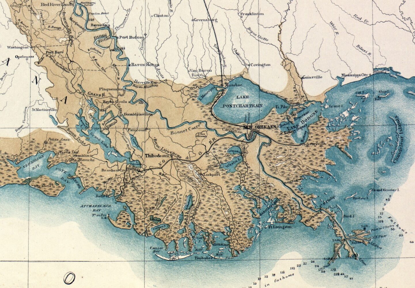
I try to be magnanimous in explaining the term to my students, sensing that its rich meaningfulness comes from its splay more so than its confinement. I do make clear delta’s original geological definition, starting with its ancient origins, and apply it to the alluvium-spewing mouths of the Mississippi and Atchafalaya Rivers. These are our active geological deltas. But I make more use of the phrase “deltaic plain of the Mississippi River,” which includes where the river previously deposited sediment over the past seven thousand years: that series of lobes emanating from the Old River area and swooping down to Iberia Parish to the south, St. Bernard Parish to the east, and Plaquemines Parish to the southeast, including New Orleans.
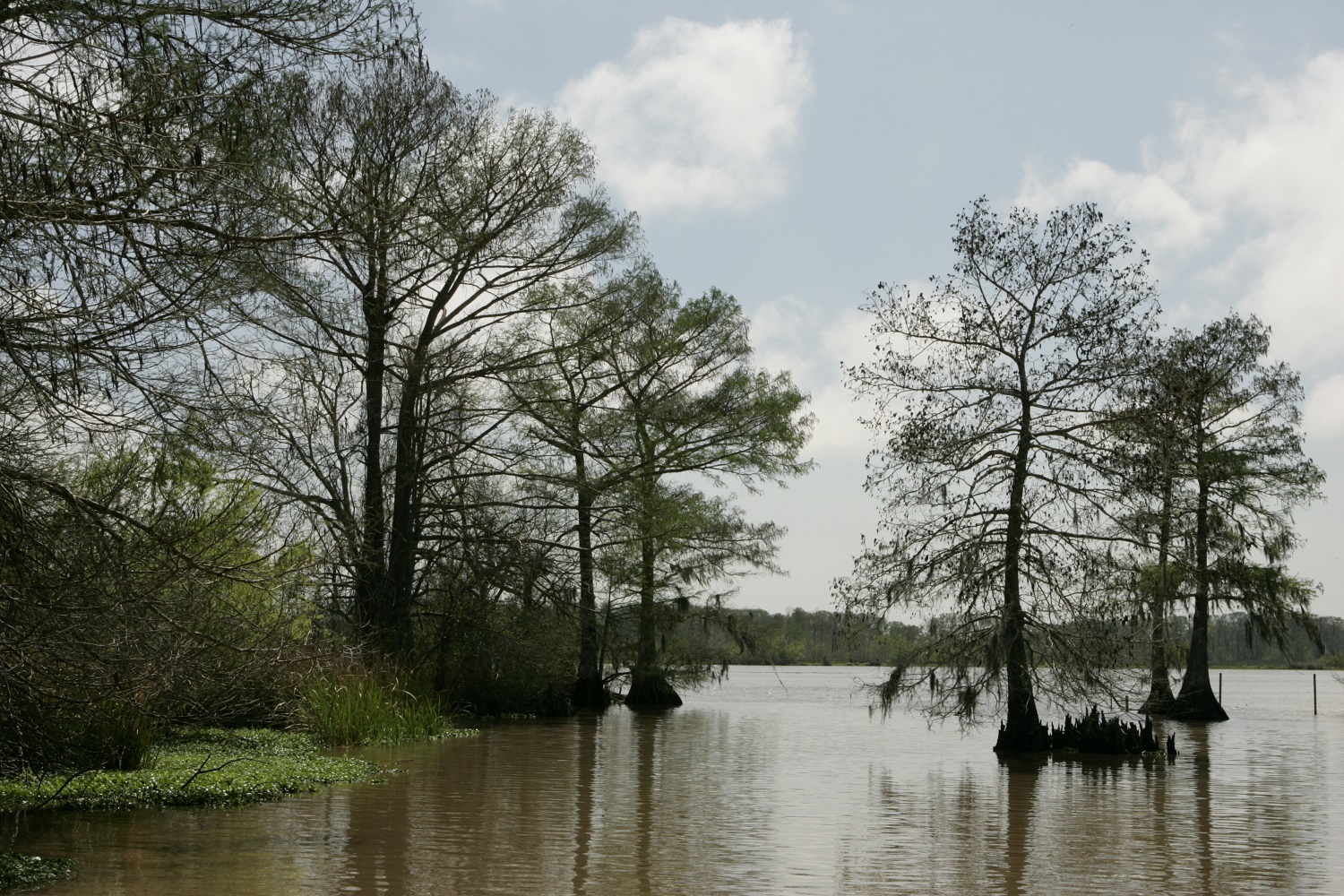
Bald cypresses in the Chenier Plain. US Fish and Wildlife Service.
I explain the Chenier Plain as a sort of derivative delta, formed as longshore currents swept river-deposited sediments westward to form Vermilion and Cameron Parishes. I discuss the alluvial valley of the lower Mississippi River, pointing out that the terraces to its west and the bluffs to its east indeed make it valley, constraining the river channel from meandering just anywhere. This cannot be said for areas south of Lafayette and Baton Rouge, where such topography disappears, and where the river can and did swing out widely in a series of avulsions. Another important distinction: rivers in valleys have tributaries; runoff flows into them. Rivers in deltas have distributaries; runoff flows away from them. Look where the lower Mississippi’s tributaries turn into distributaries, and that’s a pretty good indication of where the valley becomes a delta.
Finally, I give voice to the people who use the term “delta” to mean a cultural region, aiming to give these uses legitimacy, while also making sure students understand that these up-country bottomlands are geomorphologically distinct from their coastal counterparts.
Which brings us to a final use of “delta,” the mathematical one. There are actually a few, depending on case and context, but the most common one means the difference of two quantities. The delta between Louisiana’s population in 2000 and in 1900, for example, is 3,087,351 people (4,468,976 minus 1,381,625). Mathematics makes abundant use of the Greek alphabet, not to mention Roman letters, so it’s no surprise that Δ and δ (lower-case delta) got put to its service.
More to our topic, geographers who work with elevation data often use the phrase “delta Z” to mean a change in elevation over time. (In mapping, the X dimension is longitude, Y is latitude, and Z is elevation.) In that regard, our Louisiana delta definitions dovetail. All that river-borne alluvium had once changed the land elevation in the upper delta—delta Z upward—just as it raised the deltaic plain above the level of the sea. And as every reader of 64 Parishes knows, we’re currently starving the deltaic plain of new sediments, while rising seas are intruding and eroding.
The result: delta Z downward, which if we don’t reverse in time, will cost us both geology and culture.
Richard Campanella, a geographer with the Tulane School of Architecture, is the author of The West Bank of Greater New Orleans, Cityscapes of New Orleans, Bienville’s Dilemma, and other books. He may be reached through richcampanella.com, [email protected], or @nolacampanella on Twitter.