Geographer's Space
The Speed of Culture
Two centuries ago, commerce and culture moved at the Mississippi’s pace
Published: March 1, 2019
Last Updated: May 31, 2019

National Gallery of Art
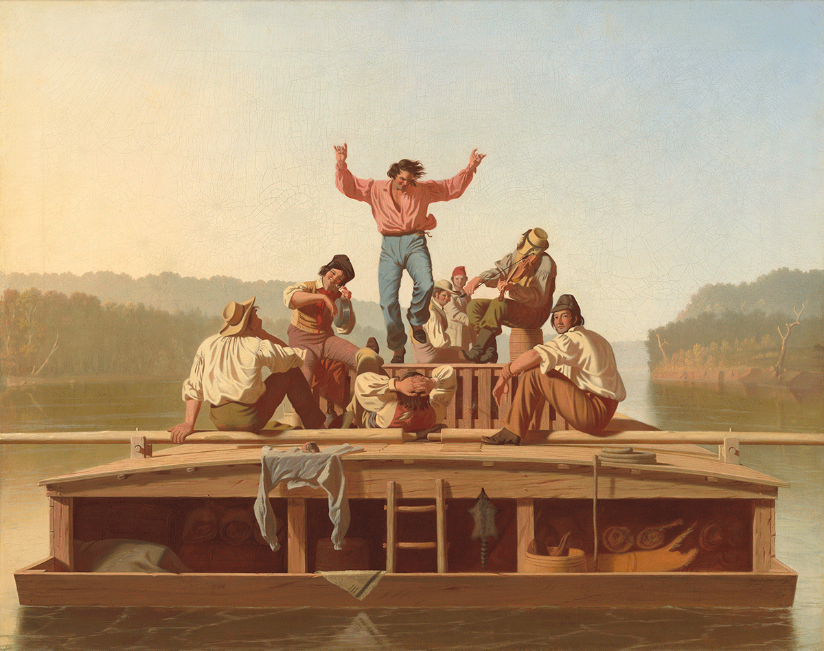
The Jolly Flatboatmen by George Caleb Bingham, 1846.
How long did it take to travel the Mississippi two centuries ago? The question, while a technical one, has humanities implications because, until the rise of railroads in the 1830s, telegraphy in the 1850s, and telephony in the 1870s, most human culture moved no faster than the swiftest vessel. People and power, ideas and innovations, information and perspectives, supplies and equipment, commodities and foodways, language and music: all traveled long distances primarily by waterborne means, as they had for millennia.
On the Mississippi, vessel typology had changed by the early 1800s, but speed had not. Native Americans used birch-bark and bison-skin canoes or dugouts and pirogues fashioned from logs. Frontiersmen adapted these designs by splitting hollowed logs and inserting planks to form “skiffs,” capable of carrying light cargo, and tapering blunt ends to produce a more maneuverable bateau. Heavier loads and longer journeys called for bulkier rafts known as “flatboats.” Wrote one observer in 1847, “A flat-boat is nothing more than a quadrangular floating box . . . of rough sawn planks, and . . . a crude kind of cabin, made sufficiently water-tight to [reach] its destination, and no more.” Crude as they were, flatboats were the premier means of getting Western produce to market in the early 1800s.
Flatboats had no means of propulsion other than the current. High springtime waters meant a steeper gradient and higher water velocities. When the river ran low, in late summer through early winter, velocity dropped by at least half. Flatboatmen loved high water for its speed and evasion of sandbars and other navigation obstacles.
One flatboatman reported covering “ninety miles in twenty-four hours” near Natchez, or 3.75 miles per hour. An English traveler in 1828 reported that “the current [brings flatboats] down at a rate of four miles an hour.” The Navigator, a guide book published from 1801 to 1824, reported that a typical flatboat launched around Rockport, Indiana, took four or five days to float down the Ohio and three to four weeks down the Mississippi to New Orleans, a thirteen-hundred-mile total trek covered at forty to fifty-two miles per day, or three to five miles per hour.
Nocturnal navigation could double daily mileage, but raised the risk of entanglements and crashes. The Navigator advised variously on this matter. For the Ohio, it held that rest stops not only squandered time but increased exposure to bankside hazards, recommending “you should contrive to land as seldom as possible; you need not even lie by at night, provided you trust to the current[;] if you have moon light so much the better.” For the main channel of the Mississippi, fraught with driftwood and sandbars, “it [is] imprudent . . . to go after night, even when assisted by a clear moon,” but “once arrived at Natchez you may safely proceed day and night, the river from that place to its mouth being clear.” Most boatmen navigated opportunistically, floating into darkness if they thought favorable conditions mitigated the danger, and tying up if they fouled.
Once docked at New Orleans, flatboatmen vended their cargo and dismantled their bulky craft, which were now useless against the current. The scrap wood went to anything from levee planking to banquettes, fences, firewood, or “bargeboard houses.”
Getting back upriver was the tough part. Prior to the mid-1810s, travelers had two options: go by foot or horse the entire distance, using wilderness roads such as the Natchez Trace. The second option was to take a “keelboat” as far upstream as possible, then continue by land.
A keelboat was something like a fusion of a canoe and a flatboat, specially designed for contra-current navigation. Like a canoe, a keelboat had a ribbed hull with rounded edges, a pointed bow and stern, and an elongated overall shape. Like a flatboat, it was large, flat-bottomed, had minimal draft, and accommodated storage space for cargo and shelter for crew. Unlike canoes and flatboats, however, keelboats usually required specialized labor to construct and pilot. With their upturned ends, multiple oarsmen, and single sail, keelboats had an anachronistic Mesopotamian look. They were excruciatingly slow, progressing at half the speed of a slow flatboat coming in the opposite direction.
All this changed after steam engines were adapted to river navigation starting in 1812. Steamboats relegated keelboats to narrow tributaries, and eventually rendered them obsolete. Flatboats, however, were so cost-effective that they managed to coexist with steamboats into the 1860s. Flatboatmen would bring cargo downriver for free, then sell the cargo, dismantle the boat, and return upriver by steamboat, often getting free passage in exchange for providing on-board labor for tasks like refueling and maintenance.
How fast did steamboats go? In 1821, Adam Hodgson steamed 320 miles upriver in high water from New Orleans in four days, or eighty miles per day. An 1832 account recalled it took “about 7 Days to [reach] Evans ville Indiana” [sic] from New Orleans, a 1,193-mile journey traversed at an impressive 170 miles per day. An 1834 traveler wrote that “a journey from New Orleans to [Cincinnati, measuring 1,560 river miles] can now be performed in twelve” days, or 130 miles per day. Ninety or one hundred miles per day was typical, and gaslight illumination enabled nighttime travel.
We may surmise that, prior to steamboats, cargo and culture took a long month to get from Cincinnati to New Orleans, and two to three months to return. Steamboats shortened the journey to ten to fifteen days in either direction. Letters, documents, newspapers, books, supplies, merchandise, art, furniture, cash, commodities, people—in a word, culture—traveled no faster than these velocities. Only a rider on a galloping horse could go faster, carrying little more than a stuffed mailbag.
Bustling river commerce put the distant and exotic metropolis of New Orleans practically in the backyard of rural Westerners. “When [Indiana] pioneers spoke of ‘going to town,’” recalled one old boatman, “they meant to New Orleans. . . . Not a few of our early statesmen came here from Louisiana, and much early business was transacted at New Orleans. It was our early market.”
The river afforded two-way economic exchange and cultural diffusion. Kentucky vessels, wrote Timothy Flint in 1826, carried “pork, flour, whiskey, hemp, tobacco, bagging, and bale-rope.” Foodstuffs and whiskey joined raw materials derived “from regions, thousands of miles apart . . . and floated to a common point of union.” In other cases, according to historian Archer B. Hulbert (1921), “[s]alt, iron, cider and peach brandy” flowed south, while “molasses, sugar, coffee, lead, and hides” headed north. Recollected one aging Hoosier about a fellow flatboatman, “he brought with him the first oranges and cocoanuts that ever came to Indianapolis. . . . [O]n his return from ‘Orleans’ he took delight in [showing] little children . . . his stock of tropical fruits and to gladden their child-hearts with presents.”
A young Kentuckian flatboated to New Orleans in 1828 and 1831, returning with a head full of new perspectives. It was the young man’s first experience with the abysmal state of Western “internal improvements” (transportation infrastructure), his first time in a big cosmopolitan polyglot, and his first up-close look at lower-South plantation bondage and large-scale slave-trading. The youth went home changed on account of his river trip to New Orleans, and it would influence the rest of his life.
His name was Abraham Lincoln.
Richard Campanella, a geographer with the Tulane School of Architecture, is the author of Cityscapes of New Orleans, Bienville’s Dilemma, Bourbon Street: A History, and Lincoln in New Orleans, from which this material was drawn. He may be reached at richcampanella.com, [email protected], or @nolacampanella on Twitter.
