Historical Archaeology in Louisiana
Archaeologists at sites across Louisiana help fill in the written record through physical excavations of the past.

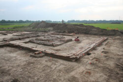
Photo by Joanne Ryan, courtesy of Coastal Environments, Inc.
Excavations of the Plaisance Plantation’s boiler room foundations help archaeologists understand the layout, functions, and changes to the Iberville Parish sugarhouse over time.
Archaeology is the study of past human activity through its surviving material remains. Historical archaeology is a sub-discipline of this field that focuses on the period of recorded—or written—history, which in the Americas began when Europeans first encountered resident indigenous populations. While prehistoric archaeologists have only archaeological artifacts, objects made and used by people, to examine, historical archaeologists use both historical records (documents, photographs, letters, newspapers, etc.) and artifacts to understand and interpret the past. Both data sets are inherently incomplete, as numerous documents, and the most fragile of artifacts (including basketry, textiles, plant remains, and sometimes bone), are lost to fires, floods, humidity, and acidic soils. Surviving documentary sources were produced by, and represent only, the small fraction of the population that could read and write (and chose to do so) prior to the twentieth century. These sources also have a limited scope, as few people recorded the humdrum of everyday life or what was then considered to be common knowledge. In contrast, artifacts (such as dishes, clothing, tools, furniture, housing, and even land) were used by everyone, and so reflect a broader spectrum of the population. Historical archaeology ties history to the ground, relating specific places and people to the broader patterns of local, national, and even international events.
Overview
Historical archaeology in Louisiana reflects the international nature of the state’s history. Unlike in many other states, documentary sources in Louisiana are not only in English, but also in French, Spanish, and sometimes an amalgamation of those two languages. Its legal documents differ too, because Louisiana adopted a version of the Napoleonic Code of civil law prior to becoming a state (the English common law tradition is practiced in the rest of the United States). Per the Code, all property transfers and many wills, marriage and building contracts were drafted, guaranteed, and archived by notaries. The Code also instituted forced heirship, which legally guaranteed a child a share of his or her parents’ estate—a factor that greatly affected land-use practices in Louisiana over time. While the British system of metes and bounds, or the public land survey system of 640-acre squares, were used in most other states, Louisiana was partly surveyed using the French arpent system, resulting in long, narrow (and sometimes pie-shaped) parcels of land oriented perpendicular to navigable waterways. These provided each landowner with river frontage (vital for transportation, communication, and the protections of natural levees), cultivatable land, and backswamps rich in timber (needed for construction and fuel). Long lots dictated where people would live—typically along the waterfront, and this is where most early archaeological sites are located.
Louisiana’s artifacts are just as cosmopolitan as its historical records, in part due to New Orleans’s importance as an international port. Ceramics were imported from France (faience), Spain (majolica), Great Britain (delft, creamware, and pearlware), Germany (salt-glazed stoneware), and China (porcelain) before local production could meet demand and tariff restrictions were imposed. French wine bottles and cosmetic, or ointment, jars, called rouge pots, are commonly found, as are Spanish olive jars and silver coins.
Practicing archaeology, historic or prehistoric, in Louisiana is challenging given the state’s geology. The Mississippi River and its alluvial valley dominate much of the landscape, and the state’s major waterways, regularly changed course until confined by the modern levee system. This shifting could quickly bury sites with alluvium (deposits of sand, soil, gravel, or clay left behind when waters recede) or expose and destroy them via cutbank erosion. Subsidence and sea-level rise have also submerged many coastal sites, a process exacerbated by coastal erosion.
As waterways cover almost a fifth of the state, shipwrecks are an important component of Louisiana’s historical archaeological record. Most are studied by underwater archaeologists, but given the shifting of the state’s waterways, some shipwrecks formerly in water end up on land and vice versa. Stone is rare in this alluvial environment; most structures were built of wood, mud, and brick, which are more ephemeral materials that don’t always survive in the archaeological record. The high water table in South Louisiana prevented buildings from having basements, while frequent flooding required many to be raised up to a full story off the ground. As the river migrated, homes and other structures were regularly set back to prevent them from being eroded into the river. As a result, standing structures belonging to an archaeological site are sometimes removed from their associated subsurface remains.
Historical archaeologists in Louisiana divide the past five hundred years into four major time periods, based on political and social changes as well as changes in material culture: Historic Exploration (1541–1803), Antebellum (1803–1860), Civil War and Aftermath (1860–1890), and Industrial and Modern (1890–Present). Locations best suited to habitation were often repeatedly occupied, so that most of Louisiana’s historic sites have components dating to several of these time periods.
Historic Exploration (1541–1803) and the Colonial Period
Although the Hernando de Soto expedition passed through northwest Louisiana in the 1500s, it left little behind but disease. Therefore, the arrival and settlement of the French in 1699 is generally accepted as the beginning of the historic period in Louisiana. During the colonial period, Canadian, European, African, and Anglo-American immigrants established frontier settlements among the indigenous Native Americans. The earliest evidence of Europeans in Louisiana comes from aboriginal sites containing European trade goods. Sites associated with the Alabama, Bayogoula, Biloxi, Caddo, Chitimacha, Choctaw, Houma, Tunica, and other Native American groups have yielded such items. For instance, the archaeological remains of the Grand Houmas Village (1713–1785), depicted on French period maps, were identified in Ascension Parish in 1983. A dense concentration of artifacts found in a plowed agricultural field included several hundred sherds of aboriginal pottery, fourteen European trade beads, and ceramics dating from the eighteenth and nineteenth centuries. In 1883, grading for construction of a segment of the New Orleans, Mobile, and Texas Railroad in the site area had exposed three burials and one possible mound. Found with the burials were necklaces of European beads, brass bracelets, an iron pot, several glass bottles, aboriginal and European ceramic vessels, and a musket. A silver medal, engraved, decorated, and dated 1727, was discovered in the same area. The French and Spanish gave such medals, sometimes known as “peace medals,” to the chiefs with whom they conducted official negotiations. These finds help researchers understand how Native Americans managed the complexities of European interaction.
Fort, mission, concession, and small farm sites are characteristic of the latter portion of this time period. Los Adaes, in Natchitoches Parish, is the remains of a Spanish presidio and mission that served as the capital of the province of Texas from 1729 to 1770. The mission was intended to convert the indigenous Adai to Catholicism, and the fort to counter the French military presence in nearby Natchitoches. Archaeological investigations have identified a house, trash, and cooking pits; wells; two bastions; and portions of the stockade trench, moat, and governor’s house. Aboriginal pottery, some of which imitate European forms, and animal bone constitute most of the artifact assemblage from this site. European items include glass trade beads; French, Spanish, Mexican, British, Dutch, German, and Chinese ceramics; French, British, and American gunflints; French folding knives, cloth seals, kettles, and wine bottles; and Spanish horse gear. Los Adaes is considered one of the most important archaeological sites in the United States for the study of colonial Spanish culture. Its well-preserved archaeological remains illustrate the interaction of the Spanish, French, and Native Americans on the Spanish colonial frontier.
In the Louisiana colony, the French and Spanish Crowns granted tracts of land, known as concessions, to loyal subjects for political and economic reasons. Many were established near Native American villages where land had already been cleared. One French concession that has been identified archaeologically is the 1718 Paris-Duverney Concession in Iberville Parish. In the early 1940s, Louisiana State University personnel, using Work Projects Administration (formerly Works Progress Administration) labor, excavated at the Bayou Goula site, near the town of the same name, in Iberville Parish. Two occupational strata were identified. The first constituted the Paris-Duverney Concession and contained wall trenches from eight rectangular houses. Artifacts found at the site include aboriginal pottery, French ceramics, gunflints, glass beads, and bottle fragments, as well as a coin minted in 1722 in La Rochelle, France. The second occupation at this site was a prehistoric mound site buried under four to five feet of sediment that had been rapidly deposited by the Mississippi River through a crevasse, or break, in the river’s natural levee, several hundred years before the French settlement during the Coles Creek period (700–1200 CE). The concession was established adjacent to the Bayogoula-Mugulasha-Taensa Native American village. The archaeological remains of this village were identified just northwest of the Bayou Goula site in 1982. The roughly thirteen thousand artifacts recovered from the village site are overwhelmingly aboriginal but include 113 glass beads, sherds of French coarse earthenware, a Spanish olive jar, English and French gunflints, lead shot, and smoking pipe fragments. These and other contemporary sites show the types of European goods valued by Native Americans and reflect the economic relationships required to obtain them.
One immigration wave that had a profound effect on Louisiana culture was the arrival of the Acadians beginning in 1765. Driven out of Canada’s eastern coastal provinces by the British after the French and Indian War, the Acadians initially settled on the west bank of the Mississippi in St. James and Ascension Parishes, and on the Attakapas and Opelousas prairies of south-central Louisiana. Yet the archaeological remains of the small farms they established are rare due in part to riverbank erosion, levee construction, and obliteration by later occupation.
A rare survivor, the Amand Broussard site in Iberia Parish, was discovered in 2003. Broussard established one of the largest plantations in the Attakapas District. One refuse deposit at the home’s original site contained undisturbed, late-eighteenth- and early-nineteenth-century artifacts. The assemblage also contained bousillage (a mixture of Spanish moss or straw and mud or clay used to make walls) and few nails, traits characteristic of timber frame buildings, which was a French vernacular construction method brought to Louisiana in the eighteenth century. This and other early Acadian sites, such as the Paul Hébert Plantation in Iberville Parish and the Ambrose Haydel Plantation (now Whitney Plantation) in St. John the Baptist Parish, also contained historic-period aboriginal pottery, suggesting Acadian-Native American interaction through the late eighteenth century. Generally used for food storage, aboriginal pottery found at these and other Euro-American sites illustrates the multicultural economy of the times.
Antebellum (1803–1860)
In the antebellum period, much of the state’s wealth came from the farming and marketing of cash crops. Three-quarters of the population, roughly half of them enslaved men, women, and children, resided in rural areas. While subsistence farmers were common, large plantation owners garnered the most wealth and political power. Cotton and sugar plantation sites typically include several components: a main house with associated outbuildings (kitchen, milk house, chicken coop, etc.); slave quarters, yards, and cemeteries; farming-related outbuildings (mule and hay barns, corn cribs, blacksmith shops); and industrial facilities (sugarhouses, cotton presses, and gins). While some main houses remain standing, very few of the other plantation structures do.
Of the thousands of plantation main houses built in Louisiana prior to the Civil War, only about 140 survive. However, the archaeological remains of others have been identified on Nina Plantation in Pointe Coupée Parish, Westwood Plantation in Catahoula Parish, Helvetia Plantation in St. James Parish, and elsewhere. Foundations from the main house and cisterns, plus a kitchen and cabin for enslaved people laboring in household capacities such as cooks, seamstresses, maids, and valets, both of French vernacular construction, were found at Nina Plantation in 1993 and 1994. Excavations revealed numerous alterations and additions to the main house and kitchen not mentioned in historical documents. At Nina, a thick deposit of alluvium from an 1851 flood separated earlier trash deposits from later ones. Found at the former location of the Angola Plantation main house, built between 1841 and 1846 in West Feliciana Parish, were two brick chimney foundations, several brick piers, a brick stair landing, brick flooring, and brick borders and walkways. At this plantation, archaeology identified outbuildings not depicted on historic maps or mentioned in documents, including the brick foundations of a detached kitchen, a smokehouse, a dairy or icehouse, and five subterranean cisterns were located behind the main house. All these structures survived until the mid-twentieth century, by which time Angola and six adjacent plantations had become part of today’s Louisiana State Penitentiary at Angola.
Slave cabins still standing in the state are rare and quarters complexes (i.e., sets of cabins and sometimes overseer’s houses, plantation hospitals, and other buildings) rarer still. The latter may be found at Evergreen (St. John the Baptist Parish), Laurel Valley (Lafourche Parish), and Magnolia (Natchitoches Parish) Plantations. Archaeologists have identified the remains of several others. Intensive excavation in the Ashland–Belle Helene Plantation quarters, built between 1840 and 1842 in Ascension Parish, uncovered the brick foundations from eighteen cabins, an overseer’s house, and a blacksmith shop. The cabins were located behind the plantation main house, in two rows paralleling the road to the plantation’s sugarhouse. They were whitewashed, had brick rubble landings instead of porches, and glass windows, a rarity prior to the Civil War. At least one cabin had a fenced-in yard for a garden and/or livestock. Animal bones from the quarters show that the occupants supplemented their diet of cheap cuts of cow and pig meat with fish and wild game. Archaeological research at a few sites has shown that some enslaved people had access to guns for hunting. Tobacco pipes, a harmonica, dolls, and marbles were among the artifacts recovered from the Nina quarters. Several items, including a pierced 1793 Spanish real, glass beads, pierced shells, buttons, and smoothed stones, most often found near the cabin hearths, may have been used as charms or amulets. Some plantation quarters remained in use well into the twentieth century, occupied after the Civil War by freedmen and their descendants, imported Chinese and Italian laborers, families of Acadian descent, and even Polish, Latvian, and Lithuanian refugees following World War II.
Louisiana had more than 1,500 sugarhouses in 1850, but only two antebellum sugarhouses survive, while the former locations of just 130 or so have been recorded as archaeological sites. The two standing sugarhouses are at Avery Island in Iberia Parish (built circa 1830), and Rosalie in Rapides Parish (built circa 1845). On a few sugarhouse sites, such as Chatsworth Plantation in East Baton Rouge Parish and Forstall Plantation in Jefferson Parish, the brick ruins of large machine foundations, and more rarely walls, remain standing. Most sites, however, exhibit nothing above ground except a scatter of brick rubble. Below ground, the seven sugarhouse sites that have been extensively excavated contained hundreds of intact features.
While sugar records exist that document sugar yields by plantation, the records contain nothing about the number or type of engines, boilers, pumps, or kettle trains employed, or the various materials used to fuel them. Archaeology is needed to answer these questions, and to document each sugarhouse’s size, layout, construction method, and growth over time, as well as the arrangement of the equipment within it.
For instance, archaeological remains at the 1830–1890 Plaisance Sugarhouse in Iberville Parish showed that this building was initially a two-room boiling and curing house. The grinder was originally horse powered, but later converted to steam. At the 1851–1880 Arcadia Sugarhouse, adjacent to Plaisance, brick foundations indicated that this building initially contained a grinding room, boiling room, and cooling room. Arcadia’s kettle train was originally fire heated but was later replaced with a steam train.
Antebellum (and earlier) sites also exist in urban parts of the state. Although blanketed by urban development, New Orleans is rich in archaeological remains, many of which are preserved under modern pavements. In the city’s French Quarter in 2004 and 2005, the former location of the House of the Rising Sun Hotel was revealed beneath the concrete floor of a tin-roofed parking shed. Built as a residence around 1795 and destroyed by fire in 1822, the Rising Sun was replaced by another hotel, which likewise burned prior to 1908. This was replaced with a brick parking garage around 1915. Sealed beneath the garage floor were well-preserved deposits associated with a proto-historic Native American encampment, a French colonial garden, a Spanish colonial dwelling, and a late Spanish/early antebellum boarding house. Materials dating to the city’s disastrous 1794 fire and the 1822 fire that destroyed the Rising Sun Hotel were particularly well preserved. In the older deposits were aboriginal pottery, faience, majolica, Spanish roofing tiles, and abundant animal bones, while rouge pots and liquor bottles typified the hotel-era finds. The latter artifacts suggest that the hotel may have served as a brothel prior to 1822, a function intentionally excluded from the documentary record.
Civil War and Aftermath (1860–1890)
The American Civil War (1861–1865), Federal occupation, and the emancipation of enslaved people dramatically altered life on plantations and in New Orleans. The last major military action in Louisiana was the Union’s Red River Campaign to capture Shreveport and cut Texas and its resources off from the rest of the Confederacy. After the war, many planters, having lost access to enslaved labor and the capital their ownership represented, lost their land. Cheaper and easier to produce than sugar, rice grew in importance, with cultivation eventually shifting from the Mississippi River to the southwest Louisiana prairies. The state’s plantation economy did not stabilize until the 1870s.
Archaeological sites in the state from this time period include forts, battlefields, cemeteries, and shipwrecks. While not a fortification, Bailey’s Dam in Rapides Parish is a unique period construction examined by archaeologists in the 1980s. In 1864, a Union naval squadron, in retreat after the battle of Mansfield, was trapped in low water above rocky rapids on Red River at Alexandria. Lieutenant Colonel Joseph Bailey, a Union engineer and former lumberman, designed a dam to raise the river level and free the ships. The lower dam consisted of a tree dam on the east bank of the river, a series of cribs on the west bank, and a middle section made of four sunken coal barges. Three small cribs constituted the upper dam. The 29th Maine Volunteer Infantry Regiment, emancipated freedmen in the 97th Regiment, and the 99th Infantry Regiment of United States Colored Troops did most of the construction work.
Archaeologists recorded a one-hundred-foot segment of the tree dam during low water. The trees were shorn of limbs and oriented with their tops downstream. Brick and stone rubble was piled on the upstream ends of the logs, and sand and mud packed between them. Archaeology revealed that the cribs, normally built of logs and filled with stones, were actually constructed of hewn timbers from nearby buildings and filled with clayey sand, capped with stone, brick, and part of at least one sugar kettle. Side-scan sonar was used to determine that part of one of the cribs in the upper dam remained intact.
In the early 1990s, remote-sensing surveys and geological coring located the remains of two Civil War–era steamboats, buried by more than thirty feet of alluvium, on the Red River in Grant Parish. Union ironclad gunboat USS Eastport had been scuttled at this location in April 1864, while the side-wheel steamboat Ed. F. Dix struck and sank on top of the Eastport in June 1865. The sunken remains of the CSS Arrow, a wooden coastal steamboat converted into a Confederate gunboat in 1861, were located during a magnetometer survey of the West Pearl River in St. Tammany Parish in 1991. Through additional survey and scuba diving, the ship’s identity was verified in 1993. It constitutes one of the few Confederate naval vessels in the country to be discovered and studied. Built circa 1856, the Arrow was a low-pressure, side-wheel steamer built for the Lake Pontchartrain and Gulf Coast trade. It was intentionally burned in 1862 to prevent it from falling into Federal hands. Detailed mapping of the wreck revealed that the bow was largely intact, while two-thirds of the hull and part of the stern were also preserved. Most of the artifacts from this site consisted of metal ship fittings and fasteners and cabin accouterments, but tools, engine parts, and armaments, including solid and canister shot for the ship’s single thirty-two-pounder cannon, were also recovered. The location of the shot indicated where and how the gun was mounted, and an embossed copper alloy plate that the engine was likely manufactured in Britain. Excavations likewise yielded a badly burned 1853 or 1858 silver dime minted in New Orleans.
Industrial and Modern (1890–Present)
By the turn of the twentieth century, timbering, facilitated by the railroads, had largely overtaken agriculture in much of Louisiana. This industry declined once major forest tracts had been cut. Along the waterways, cotton and sugarcane cultivation persisted, and cattle ranching became more commonplace. The first oil in the state was discovered in 1901, and pipelines, natural gas plants, and refineries built to process it. The petrochemical industry soon followed. Agriculture and industry improved during the World Wars but suffered during the intervening Depression.
Railroads and sawmill towns are characteristic of the early part of this time period. Large-scale industrial lumbering began in Louisiana in the 1890s. Part of the sawmill complex and African American residential area associated with the Goodland Cypress Company sawmill, in Terrebonne Parish, was identified in 1979. The town was established in 1903 and grew to contain more than one hundred structures before the mill was shut down in 1916 and the company buildings removed for reuse elsewhere. As the Goodland mill was not close to a navigable waterway, railroads were used to haul logs and lumber to and from the mill. Evident in the landscape were the locations of former rail spurs and the skidding tracks that radiated out from them. Brick foundations from the sawmill and planer mill were preserved at the site, as well as the levees for the log-floating pond. Surface artifact clusters, brick piers, and several cisterns were recorded in the residential portion of the site. Also in Terrebonne Parish, the residential area for the Dibert, Stark, and Brown Cypress Company in Donner was identified in 1989. Of the over eighty surface features identified were several trash pits and privies and a former shell road. The numerous artifacts recovered from these features illustrate the commercial and domestic activities of a remote sawmill community. Extant from about 1900 to 1938, the Donner mill had separate residential areas for management and white workers of primarily Cajun descent. The layout of these house lots, and the artifacts they contained, were compared to those of the African American workers at Goodland to look for differences in social and economic class and ethnicity. The artifacts used by workers of all races were surprisingly similar, reflecting workers’ limited access to goods and shared low economic status.
Excavations also took place at the Poland Avenue Streetcar Barn site in New Orleans in 2011. Although constructed in 1861 to serve street railroad cars, the facility was destroyed by the Great Hurricane of 1915. Soon rebuilt, the barn operated until 1934 and was demolished in 1941. A gymnasium covered the site until it was damaged and removed after Hurricane Katrina. Preserved below ground were two brick-lined privies and a brick-lined well. Architectural debris, several complete bottles, and a large stoneware jug were found in all three features. These vessels were manufactured in New Orleans between 1900 and 1916. They indicate that the privies went out of use, and the well was filled, immediately following the 1915 hurricane.
The later part of the Industrial and Modern Period includes sites dating to the World War II era, such as military installations, prisoner-of-war camps, and shipwrecks. The Gulf of Mexico contains one of the greatest concentrations of Allied vessels lost to German U-boats worldwide. An archaeological survey of the seafloor in Federal waters off Terrebonne Parish, prior to construction of a natural gas pipeline, located the only known German U-boat sunk in the Gulf, U-166, as well as her last victim, the Robert E. Lee, a steam passenger ship. Remotely operated vehicles were used to explore and map the submarine in 2014 and determined that the bow of the vessel was destroyed. These investigations revealed that the sinking of U-166, previously attributed to a US Coast Guard aircraft, was the result of a depth charge fired by a US Navy patrol craft.
Despite widespread literacy and the advent of electronic communication in the late twentieth century, so much of every-day life in Louisiana continues to go undocumented. Historical archaeology helps researchers flesh out and personalize the story of the state’s historic past.