Lighthouses
Installed in the 1800s, Louisiana's lighthouses were not only among the state's most visually dynamic buildings, but also provided a vital service for commercial mariners.
Courtesy of Flickr
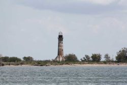
Sabine Pass Light House. Hanchey, C. (Photographer)
Lighthouses were installed in isolated waterway locations throughout coastal Louisiana in the 1800s. Usually built of brick with architectural flourishes and towering above flat coastal plains, they were among the state’s most visually dynamic buildings of their time. On a more practical level, they provided a vital service for commercial mariners and leisure boaters alike as navigational aids amid the state’s low-lying marshes and beaches, silted rivers, and dense fogs. Many lighthouses have fallen victim to the ravages of time and tide; however, a stalwart few, long since retired, have survived into the twenty-first century as quaint landmarks.
Louisiana lighthouses were impressive examples of engineering and construction—and often fine works of architecture as well. Like many functional and industrial buildings in the nineteenth century, lighthouses were conceived as monuments, not mere utilitarian structures. As representatives of their progressive era, they deserved high-style features and were often designed by architects or architect-engineers.
Sabine Pass Lighthouse
The Sabine Pass Lighthouse is located in extreme southwestern Cameron Parish, where the Sabine River, which separates Louisiana from Texas, empties into the Gulf of Mexico. The octagonal brick tower was designed by US Army engineer Danville Leadbetter in 1852. Construction began in 1854, and the lighthouse opened in 1857. Leadbetter’s towers were known for their structural innovations, and the Cameron Parish structure was no exception. In order to stabilize this lighthouse on the soft, marshy soil, Leadbetter incorporated eight finlike buttresses around the base to distribute the structure’s weight. Standing on a foundation of brick and concrete, the lighthouse reaches eighty-five feet in height and boasts eighteen-inch-thick brick walls. Within, a cast-iron spiral staircase rises to the lantern. Originally, the light consisted of an oil lamp with reflectors, but the lighting system was upgraded, as was the case for most American lighthouses later in the nineteenth century, with a multi-surface Fresnel lens that could project a stronger beam a far greater distance. A walkway with a metal railing surrounded the lantern to allow the keeper to clean the glass.
In 1952 the lighthouse was deactivated. After shuffling among governmental agencies and falling into disrepair over the next three decades, it was sold at auction for $55,000 in 1985 to two individuals who had hoped to develop a yacht basin or restaurant at the site. Those plans never materialized, and the structure was donated to a preservation group in 2001. Subsequently, a local industry financed the construction of a four-mile road to provide direct access to the lighthouse for the first time. In 2009 the Sabine Pass Lighthouse was among five Gulf Coast lighthouses featured in a set of commemorative US postage stamps.
Frank’s Island Lighthouse
Embellished in a manner similar to the Sabine Pass Lighthouse was the abandoned Frank’s Island Lighthouse that architectural historian Samuel Wilson Jr. recorded and measured for the Historic American Buildings Survey (HABS) in 1935. A lighthouse in this location—near Boothville in Plaquemines Parish on the northeast pass of the Mississippi River—was proposed following an area survey undertaken in 1806. A lighthouse designed in 1817 by Henry S. Latrobe, son of the great architect Benjamin Henry Latrobe, was built under the direction of retired ship’s captain Winslow Lewis of Boston, who later managed to acquire many contracts for the construction of lighthouses. Latrobe’s lighthouse was composed of a tapered shaft surrounded by a classical colonnade (piazza) and the light at the top.
The lighthouse was nearly completed by 1819, but poor workmanship (the builders did not follow Benjamin Latrobe’s specifications) caused the lighthouse to settle and by 1820 the tower reportedly was falling. In 1822, Lewis dismantled it and built a plain brick shaft. Knowledge of the lighthouse that was built by Lewis comes from Wilson’s drawings and the few photographs he took. Wilson had to boat out to the site to measure, record, and photograph it. His photographs give a glimpse into the isolation of a lighthouse keeper’s life.
Port Pontchartrain Lighthouse
In New Orleans, the Port Pontchartrain Lighthouse was built at the mouth of Bayou St. John. The first light here was a wooden tower, but in 1853 Leadbetter proposed a more substantial, conical brick structure. In form, it narrowed as it rose and then flared out at the top; subsidence has rendered it shorter and hourglass-shaped. Completed in 1855, the masonry structure stood within the lake, about one-quarter of a mile from the shore. A seawall and landfill projects in the 1930s made it an onshore lighthouse, but its light had already been extinguished in 1929. It later was incorporated into the midway at the Pontchartrain Beach amusement park; it now stands amid the University of New Orleans Research and Technology Park. Although the lighthouse was flooded by Hurricane Katrina, it sustained no serious damage. One of the few female lighthouse keepers, Margaret Norvell was keeper here from 1896 to 1924. Her first lighthouse posting was in 1891 to the Head of Passes Lighthouse on the lower Mississippi River, and she concluded her career as head keeper at the New Canal Light, retiring in 1932.
New Canal Light
The New Canal Light on the south shore of Lake Pontchartrain at West End was a particularly handsome example, until Hurricanes Katrina and Rita dealt it devastating blows in 2005. The first structure, an octagonal wooden tower, was built in 1838 and rebuilt in 1856 and 1890. Supported on iron piles, the square two-story wooden building—the second story smaller than the first—has four-sided roofs and is topped by the cupola lantern room. The lighthouse collapsed a few months after Hurricanes Katrina and Rita tilted and damaged it in August and September 2005. It was rebuilt, with many salvaged parts, at a cost of about $1 million and reopened in April 2013 as the New Canal Lighthouse Museum and Education Center. It is the new home of the Lake Pontchartrain Basin Foundation.
Tchefuncte River Range Rear Lighthouse
With its lantern topping the keeper’s house, the New Canal Lighthouse shows that there was no single formula of lighthouse design. But the more typical form of a tapering brick cylinder was the choice for the Tchefuncte River Range Rear Lighthouse, located where the river flows into Lake Pontchartrain near Madisonville. The first lighthouse of 1838 was replaced after the Civil War with the thirty-four-foot-tall structure that now helps pleasure boats and fishermen navigate their way from lake to river.
Southwest Reef Lighthouse
Farther west is the jaunty Southwest Reef Lighthouse. Originally, it was located about fifteen miles off the coast of St. Mary Parish and marked the entrance to the Atchafalaya Bay. Decommissioned in 1916, the lighthouse was moved, intact, in 1987; in 1991 it was re-erected in Berwick, on the west bank of the Atchafalaya River. This three-story iron tower is elevated on a platform that rests on cast-iron screw-pile legs above the water surface; such supports were easier to anchor into the soft ground. The lighthouse’s four sloping sides, sheathed in iron panels, are elaborated with molding around the first story, and a splendid cove cornice concludes the third story, giving the impression that the structure is one half of an Egyptian pylon.